
Washington State Faces Rare Storm Warning as Hurricane-Force Wind Gusts Threaten Puget Sound and Northwest Interior
SEATTLE, WASHINGTON — A powerful Pacific storm is intensifying rapidly as it moves toward western Washington, prompting the National Weather Service in Seattle to issue a rare Storm Warning for Admiralty Inlet and surrounding waters. Forecast models now show wind gusts exceeding 65 mph, with some simulations indicating gusts approaching 70–75 mph in parts of the northwest interior, including Whidbey Island and areas near the Strait of Juan de Fuca.
Meteorologists say this is an unusually aggressive upgrade for the region and signals a high-impact wind event that could rival some of the strongest storms seen in recent years.
Storm Warning Issued for Admiralty Inlet and Coastal Waters
According to National Weather Service alert maps, large portions of western Washington are now under Storm Warnings and High Wind Warnings, while adjacent areas remain under Gale Warnings and Wind Advisories.
The Storm Warning for Admiralty Inlet stands out, as forecasters note this level of warning is rarely issued for this specific zone.
“I’m not sure if I have ever seen them do that before,” one meteorologist noted, underscoring the seriousness of the evolving situation.
Storm Warnings indicate sustained winds or frequent gusts of 48 knots (55 mph) or greater, posing a significant threat to marine travel, coastal infrastructure, and inland communities.
Models Show Increasing Risk of Destructive Wind Gusts
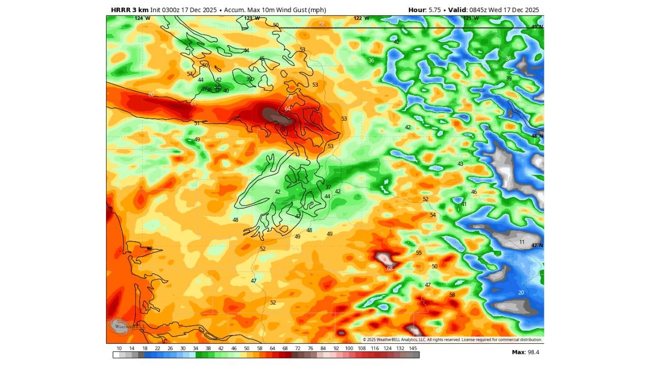
High-resolution HRRR model guidance continues to increase the maximum wind potential across the northwest interior of Washington. The latest runs highlight a core of extreme winds developing overnight and into early Wednesday morning.
Key wind projections include:
- 65+ mph gusts becoming more likely around the Strait of Juan de Fuca
- Whidbey Island at elevated risk for damaging winds
- Localized model signals showing gusts nearing 74 mph, which approach hurricane-force thresholds
The strongest winds are expected to align with a tight pressure gradient as the storm deepens offshore.
Puget Sound Communities Could See Power Outages and Damage
Cities including Everett, Bellingham, Port Angeles, Seattle, Tacoma, and Olympia fall within areas highlighted for strong to severe wind impacts. Inland valleys may experience slightly lower gusts, but still strong enough to cause downed trees, power outages, and travel disruptions.
Forecasters warn that saturated ground conditions from recent rainfall increase the risk of trees uprooting rather than snapping, which can worsen power outage potential.
What Residents Should Prepare For
As the storm moves through, residents across western Washington should be prepared for:
- Widespread power outages
- Falling trees and limbs
- Hazardous travel, especially on bridges and exposed roadways
- Dangerous marine conditions, including very rough seas and strong currents
Emergency officials urge residents to secure loose outdoor items, avoid unnecessary travel during peak wind periods, and have flashlights, batteries, and backup power plans ready.
Timing and Outlook
The strongest winds are expected late Tuesday night into early Wednesday, with gradual improvement later Wednesday as the storm system moves east and weakens. However, lingering gusts may persist in exposed locations even after the main core passes.
While confidence is high in a significant wind event, forecasters continue to monitor model trends closely for any additional strengthening or shifts in the highest-impact zones.
For the latest updates, warnings, and local impact information as this storm unfolds, stay with WaldronNews.com.