
California Braces for Potentially Historic Atmospheric River Event as Models Signal 20–30 Inches of Rain in the Sierra
CALIFORNIA — A potentially high-impact and historic atmospheric river event is taking shape across California, with forecast models signaling extreme precipitation totals over the next 10 days, particularly across the Sierra Nevada and parts of the central and northern coastline. Meteorologists warn the setup could bring dangerous flooding, landslide risk, and prolonged travel disruptions if the pattern verifies.
Atmospheric River “Firehose” Targets the West Coast
Forecast data shows a powerful and persistent jet stream aimed directly at the California coastline, creating a classic atmospheric river scenario often described as a “firehose of moisture.” Multiple model runs indicate repeated waves of moisture pushing inland, with little recovery time between storms.
This setup raises concern not just for one storm, but for a multi-day onslaught capable of producing record-level rainfall accumulations in vulnerable areas.
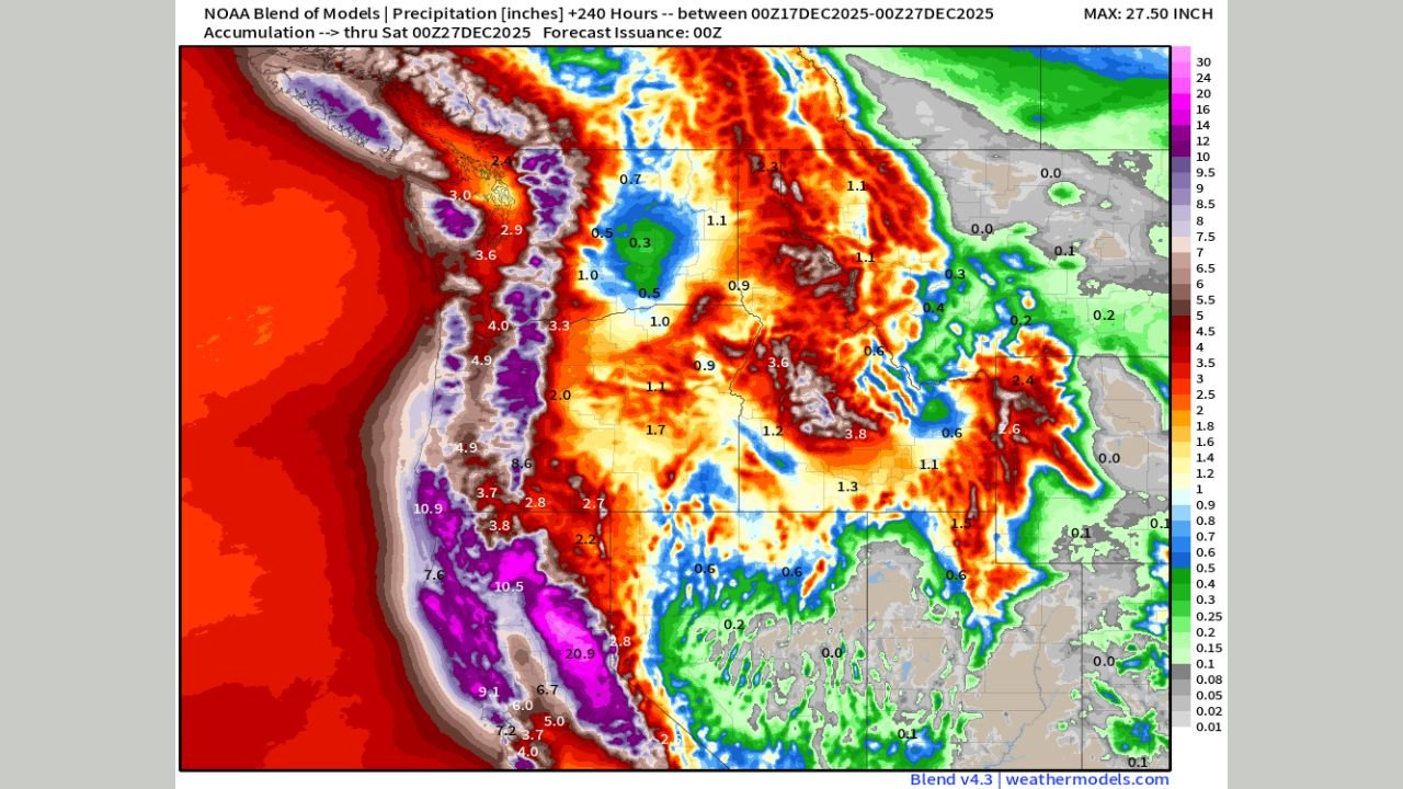
Sierra Nevada Could See 20–30 Inches of Rain Equivalent
The most alarming signals are focused on the Sierra Nevada, where some long-range guidance suggests 20 to 30 inches of liquid precipitation over the event window. While higher elevations may see some snowfall during colder phases, a significant portion of this moisture is expected to fall as rain, increasing runoff and flood potential.
Such rainfall amounts, if realized, would place major stress on rivers, reservoirs, and mountain infrastructure, especially in areas still recovering from previous wet seasons.
Flooding and Landslide Risk Increasing
With soils already vulnerable in parts of California, the forecast raises the risk of flash flooding, river flooding, mudslides, and debris flows, particularly:
- Burn scar areas
- Steep mountain terrain
- Low-lying valleys and flood-prone roadways
Urban flooding is also a concern if heavy rain bands stall over metro regions for extended periods.
Timing: Next 10 Days Critical
Models currently focus on the next 7 to 10 days as the highest-risk window, with multiple atmospheric river pulses possible rather than a single storm. Meteorologists caution that exact totals and placement will continue to evolve, but the overall wet signal remains strong and consistent across guidance.
What Residents Should Watch For
Residents across California are urged to monitor forecasts closely and prepare for:
- Rapid river rises
- Road closures in mountain passes
- Possible evacuation advisories in landslide-prone zones
- Travel disruptions due to flooding or rockslides
Emergency managers may begin issuing flood watches and advisories as confidence increases.
Forecast Still Evolving, But Risk Is Real
While exact rainfall totals can still shift, forecasters stress that the atmospheric pattern itself is well-established, making a high-impact outcome increasingly plausible. Even lower-end scenarios would still bring significant hydrologic concerns across large portions of the state.
California residents are encouraged to stay weather-aware, review emergency plans, and follow updates as the situation develops.
Stay with WaldronNews.com for continuing coverage, updated forecasts, and safety information as this potentially historic weather event unfolds.