
Washington, D.C., Maryland, and Northern Virginia Record Snowiest December Since 2017 as Region Runs Well Above Average
WASHINGTON, D.C. — Much of the Mid-Atlantic, including Washington, D.C., Maryland, northern Virginia, and southern Pennsylvania, is running above average for seasonal snowfall so far this winter, with new data showing the snowiest December in the nation’s capital since 2017.
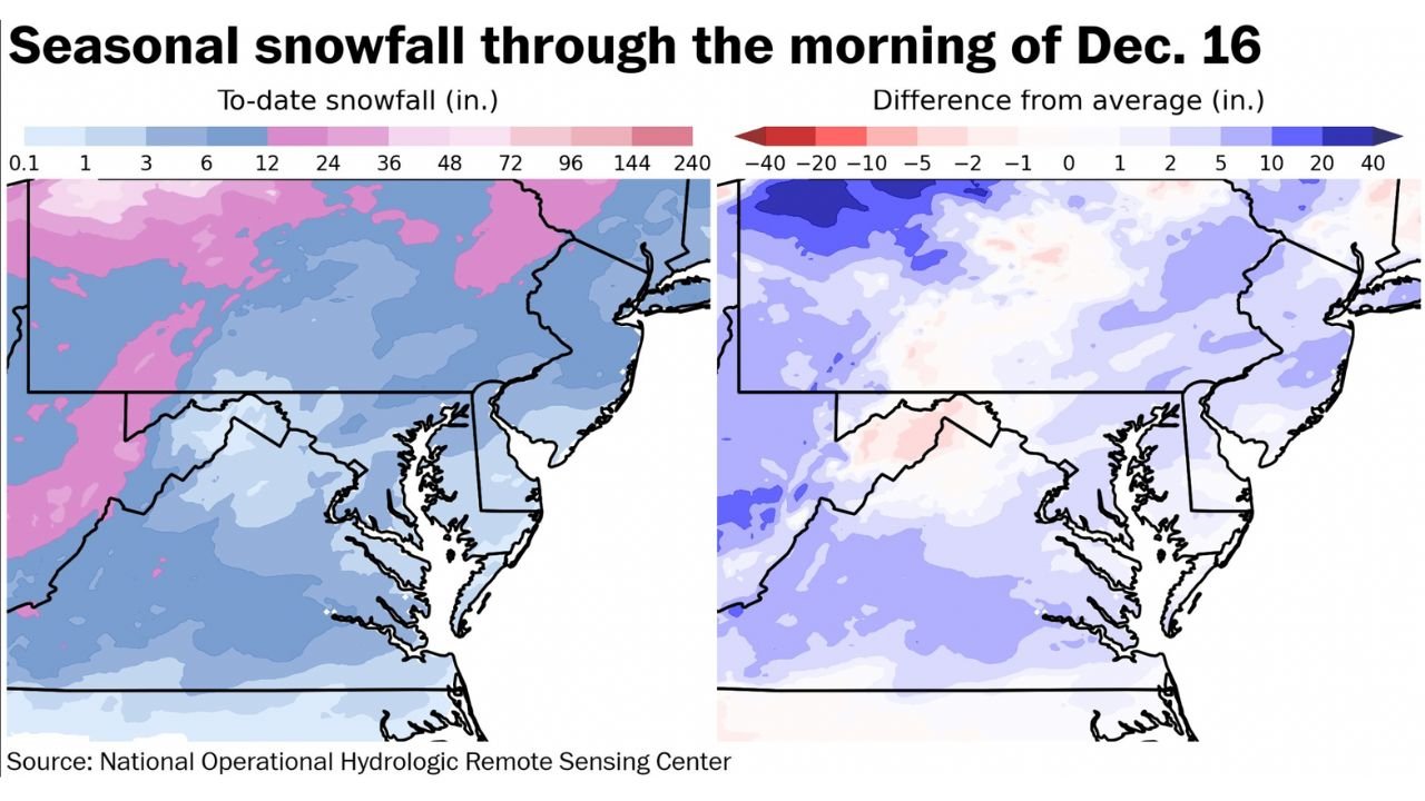
Snowfall analysis through the morning of December 16, compiled by the National Operational Hydrologic Remote Sensing Center and highlighted by Capital Weather Gang, shows widespread positive departures from average snowfall across the region — a sharp contrast from recent Decembers.
Snowfall Totals Far Exceed Recent December Norms
According to long-term comparisons, December snowfall in Washington, D.C. has already surpassed totals seen in most years since 2017.
From 2018 through 2024, the region recorded just 0.6 inches of total December snowfall combined, making this year’s early-season performance particularly notable.
“This is shaping up to be the snowiest December in D.C. and many nearby locations since 2017,” regional forecasters noted.
The snowfall-to-date map shows much of the Mid-Atlantic shaded in blue and pink, indicating several inches above normal for mid-December.
Most of the Mid-Atlantic Running Above Average for the Season
The “difference from average” map clearly shows positive anomalies across central and northern Maryland, northern Virginia, southern Pennsylvania, and New Jersey, confirming that most of the region is outperforming typical snowfall benchmarks for this point in the season.
Even areas that have not seen major storms are benefiting from multiple smaller events, steadily building seasonal totals.
“Most of the region is running above average for snowfall this season so far,” meteorologists emphasized.
Why This December Stands Out
This winter’s pattern has featured:
- More frequent cold air intrusions
- Better storm track alignment for snow
- Colder surface temperatures, allowing snow to accumulate rather than mix with rain
These factors contrast sharply with recent years, when December storms were often too warm to produce meaningful snowfall.
Can More Snow Be Added Over the Next Two Weeks?
Looking ahead, forecasters are closely monitoring the next two-week window, which could further enhance seasonal totals if additional systems develop.
“Can we add more over the next two weeks?” meteorologists asked, noting that upcoming pattern changes may favor additional wintry opportunities.
While no specific storm totals are guaranteed, the background pattern supports the possibility of continued snowfall chances heading toward late December.
What This Means for the Rest of Winter
An above-average start does not guarantee an above-average winter, but it does improve the odds of a more active cold season compared to recent years.
Residents across Washington, D.C., Maryland, and northern Virginia should remain prepared for additional winter weather, especially as the region moves deeper into peak snow season.
WaldronNews.com Weather Note
Snowfall data is current through December 16. Seasonal totals and forecasts will be updated as new storms develop.
For continued Mid-Atlantic winter weather coverage, follow WaldronNews.com.