
Arkansas and the Eastern United States Brace for Strong Late-Week Storm Bringing Heavy Rain, Gusty Winds, and Temperature Swings
WALDRON, ARKANSAS — A strong storm system is expected to move across Arkansas and much of the Eastern United States from Thursday into Friday, bringing widespread rain, gusty winds, and a sharp temperature change as it tracks from the central Plains toward the East Coast, according to forecast models and national outlooks.
Unlike recent winter systems that produced snow and ice, this storm will be warmer in nature, meaning rain will be the dominant precipitation type for Arkansas and much of the South and East. However, strong winds and thunderstorms are expected, especially as the system intensifies while moving northeast.
What’s Driving This Storm System
Forecast data shows a deep upper-level trough digging into the central United States before swinging east. As the system takes on a negative tilt, atmospheric dynamics will strengthen, allowing powerful winds aloft to transfer toward the surface, particularly across the Midwest and Northeast.
This setup favors:
- Widespread rain across Arkansas, the Mid-South, and Southeast
- Strong to potentially damaging wind gusts in the Ohio Valley and Northeast
- Thunderstorms embedded within rain bands, mainly south and east of Arkansas
Rain and Storm Threat Across Arkansas
For Arkansas, including Scott County and surrounding areas, periods of rain are expected Thursday into early Friday, with temperatures remaining mild ahead of the cold front.
The Storm Prediction Center has outlined a marginal risk for thunderstorms across parts of the Mid-South, though widespread severe weather is not expected at this time. Still, isolated strong storms could produce brief gusty winds or heavy downpours, especially late Thursday.
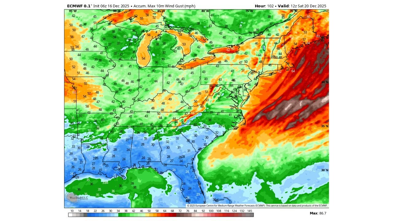
High Winds Expected Farther Northeast
As the storm strengthens and shifts toward the Great Lakes and Northeast, wind impacts will increase significantly. Forecast models indicate:
- Strong to locally damaging wind gusts across portions of the Ohio Valley, Mid-Atlantic, and Northeast
- Power outages and travel disruptions possible in wind-prone areas
- Rapid pressure changes that may cause winds to peak Friday
Cold Air Follows — With Limited Snow Potential
Behind the storm, a shot of colder air will sweep in, dropping temperatures noticeably from Friday into the weekend. While snow is not expected for Arkansas, some backside snow could develop in favored northern and higher-elevation regions of the Great Lakes and interior Northeast as colder air wraps into the system.
For most of the South, the transition will be felt more as a cooler, breezy finish to the week rather than a winter storm.
What Residents Should Prepare For
- Wet roadways and reduced visibility during heavy rain
- Strong wind gusts late Thursday night into Friday
- A warmer morning followed by cooler conditions by afternoon Friday
- Securing outdoor items that could be blown around
Forecast confidence remains moderate, and exact wind strength and rainfall totals may still shift as the system approaches.
Residents across Arkansas and the Eastern U.S. are encouraged to monitor updated forecasts and local advisories as this late-week storm unfolds.
For continuing weather updates affecting Arkansas and the region, stay connected with WaldronNews.com.