
Colorado High Wind Event Slams Boulder Area With Near-Hurricane Gusts, Causing Dangerous Travel and Damage Concerns
BOULDER, COLORADO — A powerful high wind event is impacting northern Colorado, with wind gusts approaching hurricane strength recorded across the Boulder area on Thursday, creating hazardous travel conditions and raising concerns about damage from flying debris and falling trees.
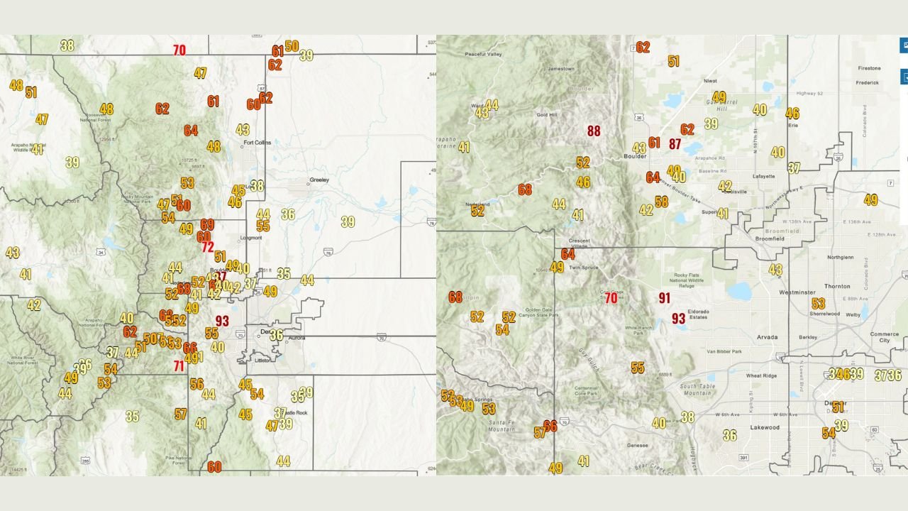
According to observations shared by local meteorologists, the strongest gust so far was an estimated 96 mph at the NCAR Mesa Lab southwest of Boulder. Additional extreme gusts were reported at 93 mph at the Arvada RAWS station near Highway 93, while Boulder Municipal Airport clocked a peak gust of 87 mph. These wind speeds are comparable to those seen in Category 1 to Category 2 hurricanes, an unusual benchmark for inland Colorado.
Where the Strongest Winds Are Being Observed
Data from regional wind sensors shows the most intense gusts occurring along the Front Range foothills, where terrain enhancement is amplifying wind speeds. Locations most affected include:
- NCAR Mesa Lab (SW Boulder): Estimated gust near 96 mph
- Arvada RAWS Station (Highway 93): 93 mph
- Boulder Municipal Airport: 87 mph
- Foothill and canyon locations west of Boulder reporting widespread 60–75 mph gusts
Winds are generally weaker on the eastern plains but remain strong enough to cause travel issues, especially for high-profile vehicles.
What’s Causing the Extreme Winds
Meteorologists say the wind event is being driven by a strong pressure gradient combined with downslope flow off the Rockies. As air descends rapidly from higher elevations, it accelerates and warms, producing very strong, localized gusts along the foothills and adjacent urban corridors.
The setup is typical of Colorado’s strongest windstorms, but the magnitude of today’s gusts places this event on the high end of historical December wind events for the region.
Safety and Travel Impacts
Officials are urging residents to remain alert as the wind threat continues. Flying objects, broken tree branches, and sudden crosswinds pose risks to both pedestrians and drivers.
Key safety concerns include:
- Dangerous travel, especially on north–south roads and highways
- Increased risk of downed tree limbs and power lines
- Potential for property damage from unsecured outdoor items
- Difficult conditions for trucks, RVs, and other high-profile vehicles
Residents are advised to secure loose objects, avoid unnecessary travel in exposed areas, and stay clear of trees during peak gusts.
What to Expect Next
Forecasters indicate that strong winds will persist through the day, with gradual improvement expected later tonight as the pressure gradient relaxes. However, sporadic damaging gusts may continue, particularly near the foothills and higher terrain.
Emergency managers and weather officials continue to monitor conditions closely and warn that additional wind advisories or warnings may be extended if conditions persist.
Residents are encouraged to stay weather-aware and take precautions as this dangerous Colorado wind event continues to unfold. For ongoing updates and local impact reports, keep following WaldronNews.com.