
California Faces High-Impact Rain Event as Southern Areas Prepare for Up to 12 Inches After Record Heat
CALIFORNIA — Forecast data shows a major rain event developing for the most heavily impacted portions of the state, following one of the wettest Novembers on record and the hottest first half of December ever observed.
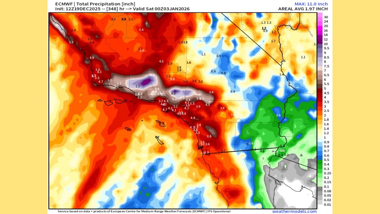
Meteorological models indicate that Southern California will experience the brunt of this system, with prolonged rainfall expected to persist for several days and continue into the early part of January.
Southern California Identified as the Most Impacted Region
Analysis of precipitation guidance highlights Southern California as the primary target, where rainfall totals are forecast to significantly exceed seasonal norms.
Urban and suburban areas are projected to receive up to 8 inches of rain, while mountainous terrain could see totals approaching or exceeding 12 inches, driven by persistent moisture flow and terrain enhancement.
Forecasters describe this as a high-confidence, high-impact rainfall setup capable of producing flooding concerns.
Recent Weather Patterns Increase Flooding Risk
The expected rainfall arrives after an extended period of abnormal warmth, which has reduced soil absorption and increased runoff potential. Combined with residual moisture from November, conditions are favorable for rapid water accumulation once heavier rainfall bands arrive.
“This system is expected to be efficient at producing runoff,” forecasters note, increasing the likelihood of flooding in vulnerable locations.
Elevated Threat in Mountain and Foothill Areas
Data shows that higher elevations face the greatest risk, where persistent precipitation could trigger:
- Mudslides and debris flows
- Rapid rises in streams and washes
- Road and canyon closures
These impacts may occur quickly during periods of heavier rainfall.
Travel and Infrastructure Impacts Expected
The duration of this event raises concerns for travel disruptions and infrastructure stress, particularly in areas prone to flooding or poor drainage.
Periods of reduced visibility, standing water on roads, and temporary closures are possible as rainfall accumulates.
Preparedness and Safety Considerations
Officials encourage residents in affected areas to remain alert and take preventative actions, including:
- Clearing nearby drainage systems
- Avoiding flooded roadways
- Monitoring local alerts and forecasts
Additional storms may follow, which could extend unsettled conditions into early January.
Outlook Moving Forward
While rainfall totals may vary by exact location, confidence remains high that this will be one of the more significant rain events of the season for the most impacted parts of California.
WaldronNews.com will continue to provide updates as the situation develops and new data becomes available.