
Texas, Oklahoma, Arkansas, and the Southeast Face Record-Breaking Christmas Heat as Temperatures Surge Into the 70s and 80s
UNITED STATES — A rare and potentially historic Christmas heatwave is taking shape across large portions of the United States, with forecast models showing spring-like to summer-like temperatures dominating the Southern Plains, Southeast, and Mid-South on December 25.
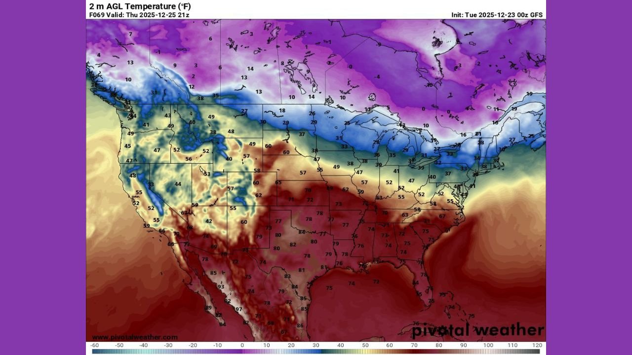
According to the latest temperature projections, afternoon highs are expected to reach the 70s and 80s across Texas, Oklahoma, Arkansas, Louisiana, Mississippi, Alabama, Georgia, and parts of Tennessee, with isolated low-90s possible in portions of southern Texas. These values place many locations near or above long-standing Christmas Day temperature records.
Southern Plains and Texas See the Most Extreme Heat Anomalies
The most significant departures from normal are forecast across Texas and the Southern Plains, where December 25 temperatures are expected to run 20 to 35 degrees above average.
Cities including Dallas–Fort Worth, Austin, San Antonio, and Houston are forecast to experience highs well into the upper-70s and 80s, levels more typical of late spring. Portions of South Texas could briefly flirt with 90 degrees, a remarkable benchmark for late December.
Meteorologists note that this level of warmth on Christmas Day is extremely rare and places parts of Texas on track for one of the warmest Christmas Days on record.
Southeast and Mid-South Join the Unseasonable Warmth
The heat expands eastward into the Southeast and Mid-South, with Arkansas, Mississippi, Alabama, Georgia, and western Tennessee all forecast to see highs in the 70s, and some locations approaching 80 degrees.
Major metro areas such as Atlanta and Memphis are projected to finish Christmas Day near or above record highs, continuing a trend of unusually warm holiday weather across the region.
Overnight lows will also remain elevated, limiting cooling and reinforcing the anomalous warmth.
Northern Tier Remains Cold, Sharpening the Temperature Contrast
While the southern half of the country experiences near-record warmth, the Northern Plains, Upper Midwest, and northern Great Lakes remain locked in seasonal to below-average cold, with temperatures staying in the 20s and 30s.
This sharp north-to-south contrast is a defining feature of the pattern, driven by a strong ridge of high pressure anchored over the southern United States, effectively blocking Arctic air from pushing southward.
Why This Christmas Heatwave Is So Unusual
Climatologically, Christmas Day typically features cold air entrenched across much of the central and eastern U.S. This year’s setup flips that script, allowing warm Gulf air to surge north unchecked.
Forecast guidance suggests this event could rank among the warmest Christmas periods ever observed for several southern states, particularly Texas and parts of the Southeast.
What Happens Next
While the warmth will make for comfortable travel conditions and eliminate winter weather hazards across much of the South, forecasters are watching closely to see how long the pattern persists beyond Christmas.
Any eventual pattern shift could bring sharper temperature swings as colder air attempts to return later in the holiday period.
Have you ever experienced a Christmas this warm in your area? Share your thoughts and local temperatures in the comments, and stay with WaldronNews.com for continued holiday weather coverage and updates.