
Western New York Wind Storm Expected to Bring 70+ MPH Gusts to Buffalo Area Monday, Forecast Models Show
BUFFALO, NEW YORK — Forecast models are continuing to signal a high-impact wind event across Western New York on Monday, with the Buffalo metropolitan area facing the potential for wind gusts exceeding 70 mph, according to the latest high-resolution guidance.
The strongest winds are expected as a powerful storm system moves through the Great Lakes region, tightening the pressure gradient and allowing intense winds just above the surface to mix down into populated areas.
When the Strongest Winds Are Expected
Model guidance shows the most dangerous wind conditions developing Monday afternoon into early evening, with peak gusts likely during this time window.
- Strong winds begin: Late Monday morning
- Peak gusts: Monday afternoon to early evening
- Gradual improvement: Late Monday night
While winds may persist for several hours, the most damaging gusts are expected in short but intense bursts.
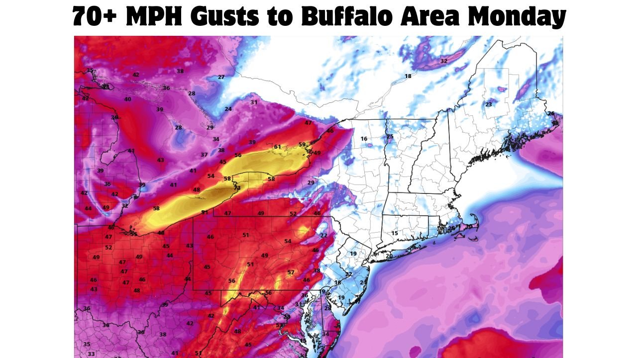
Wind Speeds Could Exceed 70 MPH
According to model-derived 10-meter wind gust projections:
- Widespread gusts of 50–60 mph are likely across Western New York
- Localized gusts over 70 mph are possible, especially near Buffalo and areas close to Lake Erie
- Lakeshore communities may experience enhanced wind impacts due to terrain and channeling effects
Wind speeds of this magnitude are capable of downing trees, snapping power lines, and causing scattered to widespread power outages.
Why This Wind Event Is Concerning
Several atmospheric factors are aligning to support unusually strong winds:
- A powerful low-level jet is moving across the region
- Very strong winds just above the surface will be present during peak mixing hours
- Cold-season dynamics allow momentum to transfer downward even without thunderstorms
This setup favors non-thunderstorm damaging winds, meaning severe impacts can occur even without lightning or heavy rain.
Areas Most at Risk
The highest wind potential includes:
- Buffalo and surrounding suburbs
- Niagara Frontier
- Lakeshore communities along Lake Erie
- Exposed hilltops and open rural areas
Urban areas may see debris hazards, while rural locations could experience tree damage and road blockages.
Possible Impacts
Residents should prepare for:
- Downed trees and large branches
- Power outages that could last several hours
- Hazardous travel for high-profile vehicles
- Flying debris in unsecured outdoor areas
Construction sites, holiday decorations, and loose outdoor items are especially vulnerable.
What Residents Should Do Now
- Secure or bring inside loose outdoor objects
- Park vehicles away from large trees if possible
- Charge phones and backup power devices
- Avoid unnecessary travel during peak wind hours
Because this event is not storm-dependent, warnings may be issued even without rainfall or thunderstorms.
Bottom Line
A significant wind storm is increasingly likely across Western New York on Monday, with the Buffalo area at risk for wind gusts exceeding 70 mph. The combination of strong atmospheric dynamics and favorable timing raises the potential for damaging impacts, including power outages and tree damage.
Residents should take this forecast seriously and remain weather-aware as the event approaches.
Stay with WaldronNews.com for updates, advisories, and any wind warnings issued as conditions evolve.