
Alaska Trough, Pacific Air Intrusion, and Cross-Polar Flow Signal Colder Mid-January Pattern Across Eastern U.S. States
UNITED STATES — Latest ECMWF ensemble guidance shows a pattern transition underway across the United States, driven by a positive EPO (+EPO) trough over Alaska that is temporarily flooding the country with milder Pacific air, before a mid-January shift toward colder, more active winter conditions across the Eastern U.S.
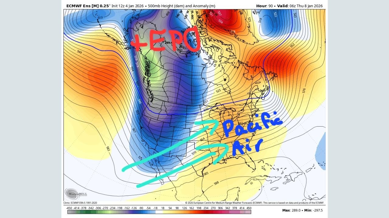
What the Current Pattern Shows Right Now
The early-week setup is dominated by a +EPO trough positioned over Alaska, allowing Pacific air to surge eastward across much of the Lower 48.
This explains the near-term moderation in temperatures, even in typically colder regions of the Midwest and Northeast.
However, this is not a locked-in warm pattern.
Model guidance clearly indicates that this phase is transitional, not stable.
Mid-Month Pattern Flip: Western Ridge and Eastern Trough
Between January 12 and January 16, ensemble means show a noticeable shift:
- A strengthening western ridge
- A deepening trough over the Eastern United States
- Increasing signs of cross-polar flow developing
This configuration is critical because it opens the door for colder Arctic air to reload into the eastern half of the country, particularly:
- Midwest
- Great Lakes
- Northeast
- Mid-Atlantic states
Why Cross-Polar Flow Matters
The data shows a transition toward cross-polar flow, meaning air masses are no longer just modified Pacific air — they originate from higher latitudes, allowing colder shots to penetrate southward.
This pattern closely resembles December’s colder reload, which brought renewed winter conditions after brief warmups.
Storm Potential: Watch, Not Hype
ECMWF ensembles also hint at cyclogenesis potential during this window due to:
- Western ridge placement
- Eastern trough alignment
- Background blocking signals
- NAO trending from negative toward neutral/positive
That said:
- This does NOT signal a major storm yet
- Snow footprints are light and scattered
- Confidence remains low at this range
This is a monitoring phase, not a forecast lock.
What This Means Going Forward
- Near-term: Milder Pacific influence continues
- Mid-month: Colder air becomes increasingly likely
- Winter pattern: Reload potential increases after Jan 12
- Confidence: Moderate on pattern shift, low on specifics
Historically, January 15 through late February is peak winter climatology for much of the Eastern U.S., and the upper-air signals support that seasonal trend returning.
Bottom Line
This is a classic January reset pattern — warmth now, followed by a return to colder, more active winter conditions, especially east of the Mississippi River.
Details will evolve, but the large-scale signals are there.
What do you think — is winter about to reload again across the eastern United States, or will the warm pattern hold longer than expected? Share your thoughts and stay updated with the latest weather pattern analysis right here.