
Lake-Effect Snow Threat Grows for Illinois and Indiana as Southern Lake Michigan Band Targets Chicago and Northwest Indiana Midweek
ILLINOIS & INDIANA — Forecasters are growing increasingly confident that a significant lake-effect snow event will develop downwind of southern Lake Michigan from Wednesday into early Thursday, with the highest risk focused on northwest Indiana and parts of the Chicago metro area. The setup could bring several inches of snow in a short time, potentially disrupting Wednesday evening and Thursday morning commutes.
Latest probability maps show a well-defined lake-effect band setting up along the southern shore of Lake Michigan as colder air pours over the relatively warm lake waters. This pattern strongly favors localized but intense snowfall, especially where the band remains stationary for several hours.
Where the Heaviest Snow Is Most Likely
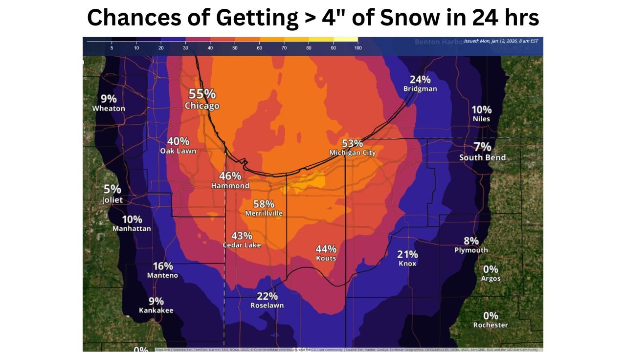
The highest probabilities for more than 4 inches of snow in a 24-hour period are centered across northwest Indiana, extending into nearby portions of northeast Illinois.
Key areas with elevated risk include:
- Merrillville, Hammond, Cedar Lake, and Kouts, Indiana, where probabilities range from 40% to nearly 60%
- Michigan City, with chances exceeding 50%
- Portions of southern Cook County, including Chicago and Oak Lawn, where probabilities climb into the 40–55% range
Farther inland, probabilities drop off sharply, highlighting how narrow and location-dependent lake-effect snow can be.
Chicago Area: Not Everyone Sees the Same Outcome
Within the Chicago metro, snowfall potential will vary dramatically:
- Near-lake and south-side neighborhoods have a much better chance of seeing plowable snow
- Western suburbs such as Joliet and Wheaton show much lower odds, generally below 10%
- Small shifts in wind direction could mean heavy snow in one neighborhood and very little just a few miles away
This makes precise placement critical and explains why forecast confidence focuses on impact zones rather than uniform totals.
Timing and Commute Impacts
The most concerning window appears to be:
- Wednesday afternoon through Wednesday night, when lake-effect bands may intensify
- Early Thursday morning, when lingering snow could affect roads during peak travel hours
If the dominant snow band locks into place, rapid accumulations could occur, leading to slick roads, reduced visibility, and slow travel, especially in northwest Indiana.
Why This Event Matters
Lake-effect snow events often outperform expectations because snowfall rates can exceed 1 to 2 inches per hour under the strongest bands. Even though this is not a widespread winter storm, localized impacts may be severe where the band persists.
Residents in the higher-risk corridor should be prepared for:
- Rapidly changing road conditions
- Difficult commutes with little advance warning
- Snow totals that vary dramatically over short distances
Bottom Line
A high-confidence lake-effect snow setup is taking shape for areas south and southeast of Lake Michigan, with northwest Indiana and parts of the Chicago metro most at risk for 4 inches or more of snow between Wednesday and early Thursday. While not everyone will see heavy snow, those under the band could experience significant, travel-impacting conditions.
Stay with Waldron News for continued updates as forecasters refine band placement and timing over the next 24 hours.