
Ohio Valley, Midwest, and Northeast Brace for Active Snow Week as Multiple Alberta Clippers and Two Arctic Blasts Move In
UNITED STATES — A highly active winter pattern is setting up across the Ohio Valley, Midwest, and Northeast, where several Alberta clippers are expected to bring repeated rounds of snow this week, followed closely by two separate Arctic air outbreaks that could deliver some of the coldest temperatures of the season to more than a dozen states.
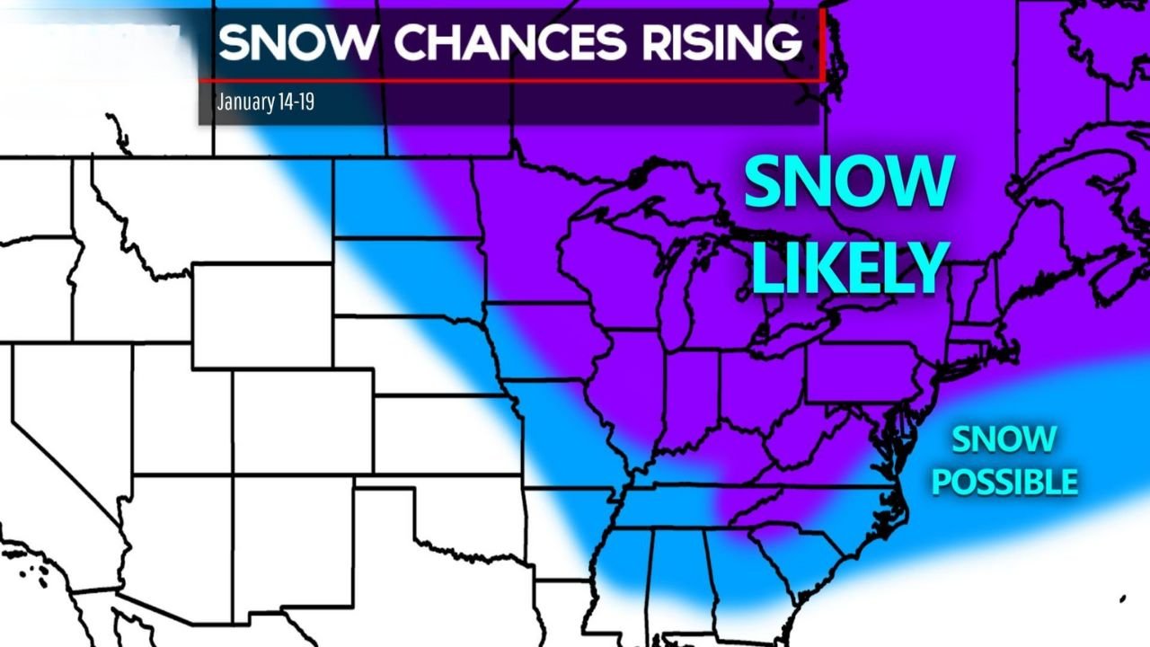
Forecast guidance shows snow chances rising sharply from January 14 through January 19, with the highest confidence focused on the central Midwest through the Great Lakes and into the Northeast, while parts of the Southeast may see snow remain possible but more limited.
Why This Pattern Is Turning More Wintry
Alberta clippers are fast-moving winter systems that originate in western Canada and typically bring quick bursts of snow, gusty winds, and sharp temperature drops. This week’s setup features multiple clippers in succession, allowing snow chances to stack up over several days rather than arriving as a single storm.
At the same time, two strong Arctic air masses are forecast to plunge south behind these systems, reinforcing cold air and increasing the likelihood that precipitation falls as snow instead of rain.
Areas Most Likely to See Snow
The highest confidence for accumulating snow extends across a broad swath of the country:
- Midwest:
Widespread snow is likely across Minnesota, Wisconsin, Michigan, Iowa, Illinois, Indiana, and Ohio, especially near the Great Lakes where colder air is well-established. - Ohio Valley:
Snow chances are elevated across Indiana, Ohio, Kentucky, and western Pennsylvania, with multiple light-to-moderate accumulations possible as clippers pass through. - Northeast:
From Pennsylvania and New York into New England, snow looks increasingly likely as cold air deepens and systems track east. - Southeast fringe:
Parts of the Tennessee Valley and southern Appalachians fall into a “snow possible” zone, where exact storm tracks and timing will determine outcomes.
What Makes This Week Different
Rather than one blockbuster storm, this pattern favors:
- Repeated snowfall opportunities
- Accumulating impacts over time
- Little recovery between systems due to persistent cold
Even modest snowfall amounts can become disruptive when they occur back-to-back, especially with cold temperatures limiting melting.
Arctic Blasts Add a Dangerous Cold Factor
Behind the snow, two Arctic blasts are expected to sweep across the central and eastern U.S. this weekend. These cold shots may bring:
- Sub-freezing temperatures across more than a dozen states
- Single-digit or below-zero wind chills in parts of the Midwest and Great Lakes
- Extended cold that keeps snow and ice on roads longer
The combination of snow followed by bitter cold raises concerns for travel delays, icy road conditions, and increased heating demand.
Travel and Safety Considerations
Residents across the affected regions should prepare for:
- Changing road conditions during multiple commute periods
- Blowing snow and reduced visibility with each clipper
- Cold-related hazards, including frostbite risk during the Arctic outbreaks
Winter travel kits, layered clothing, and close monitoring of daily forecasts are strongly advised this week.
Bottom Line
An active winter weather stretch is underway, with several Alberta clippers bringing snow to the Ohio Valley, Midwest, and Northeast, followed by two rounds of Arctic cold that will intensify impacts. While individual snow totals may vary, the cumulative effects of repeated snow and extreme cold could make this one of the more impactful winter weeks so far this season.
Stay with Waldron News for daily updates, regional snow timing, and cold-weather alerts as this dynamic winter pattern unfolds.