
Pennsylvania, New York, Vermont, New Hampshire, and Maine Targeted for Late-Wednesday Snow Into Thursday as Models Boost NEPA Totals and Northeast Winds
PENNSYLVANIA – Overnight forecast guidance, especially the Euro and NAM, has nudged snow chances higher for northeast Pennsylvania (NEPA) heading into Thursday, while keeping the primary target zone the same: NEPA, Upstate New York (CNY/ENY), and Northern New England. Another important trend in the newest data is timing — the start has shifted earlier, with snow developing late Wednesday night and continuing into Thursday, rather than waiting until later Thursday.
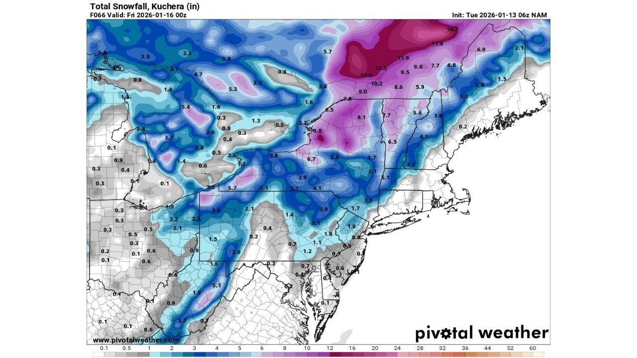
The snowfall maps shared with this update show a broad winter swath across the interior Northeast, with the best accumulation potential focused away from the immediate coast. The same guidance also highlights gusty northeast winds, which can lower visibility at times and make travel feel worse than the totals alone suggest.
What changed in the overnight guidance
The key change is not a wholesale shift in where the storm is aimed — it’s a tightening of the band and a bump in snow potential in the NEPA corridor. In the latest set of maps, NEPA sits closer to the axis of steadier accumulation, while Upstate New York and parts of Northern New England remain favored for higher totals.
The other notable change: earlier onset. Instead of a purely “Thursday event,” the better window for snow now looks like it begins late Wednesday night, which matters for road conditions during the overnight and early-morning hours.
Primary impact zone by state
Based on the placement of the heavier snow shading in the model snowfall output, here’s how the target area breaks down:
- Pennsylvania: The best accumulation signal is concentrated in northeast Pennsylvania, with lighter totals farther south and toward the coastal plain.
- New York: Upstate New York, including parts of Central New York (CNY) and Eastern New York (ENY), remains a core target for accumulating snow.
- Vermont and New Hampshire: Interior sections show a stronger snow signal than the immediate coastline, with totals increasing northward and with elevation.
- Maine: Northern and interior sections have better odds for accumulating snow than the coastal strip, where warmer air can sometimes limit totals.
What the snowfall maps suggest for totals
Because these are model projections (and totals will still change), the best way to communicate this is as reasonable ranges that match what the latest maps are implying:
- Northeast Pennsylvania (NEPA): A plowable event is on the table, with the current clustering suggesting roughly 3 to 6 inches in the most favored bands. Some nearby areas may land lower if the band wobbles.
- Upstate New York (CNY/ENY): This remains the higher-confidence “accumulation zone,” with many areas positioned for around 5 to 10 inches, and localized higher totals possible where the snow is most persistent.
- Northern New England (VT/NH/ME): A broad stripe supports several inches, commonly 3 to 8 inches, with higher terrain and farther-north locations favored for the upper end.
The reason totals look so different over relatively short distances is that the storm’s snow band is likely to set up in a corridor where lift is strongest. If you’re 30–50 miles away from that corridor, totals can fall off quickly.
Timing: earlier start, Thursday impacts
The latest messaging points to this general timeline:
- Late Wednesday night: Snow begins expanding into NEPA and Upstate New York, with initial accumulation possible on untreated roads.
- Overnight into Thursday morning: Snow continues, and impacts increase for commuters — especially if rates briefly pick up.
- Thursday daytime: Snow gradually tapers from southwest to northeast, though exact ending time will depend on the storm’s track and how quickly dry air wraps in.
If you’re in NEPA or Upstate New York, the “late night start” is a big detail. It raises the odds of slick roads for the first part of Thursday, even if snow is not falling heavily at that moment.
Gusty northeast winds: why it matters
The mention of gusty northeast winds is more than just an extra line in the forecast. Even moderate winds can:
- Create blowing snow in open areas, briefly reducing visibility
- Lead to drifting in rural spots if the snow is drier
- Make travel feel worse than totals alone would suggest, especially on higher-speed roads
Winds also tend to be most noticeable across exposed ridges, hilltops, and open valleys, which aligns with parts of Upstate New York and Northern New England.
Biggest uncertainties to watch
Even with improved agreement, there are still a few forecast “levers” that can change totals:
- Band placement: A small north/south shift can raise totals in one county and cut them in another.
- Coastal influence: Along the immediate coast, slightly warmer air can mean mixing or lower ratios, trimming totals.
- Snow intensity: If the system produces a narrower, heavier band, localized totals can beat the regional average.
This is why the overnight update matters: it hints at better organization, but it also reinforces that the final outcome will be sensitive to exact placement.
What to do now
If you’re in Pennsylvania (NEPA), New York (Upstate/CNY/ENY), Vermont, New Hampshire, or Maine, Thursday planning should assume at least some winter travel impacts:
- Consider finishing longer driving Wednesday evening before the late-night start.
- Prepare for slick roads early Thursday, especially on secondary routes.
- If you’re in a higher-total zone, plan for slower travel and reduced visibility at times due to wind.
Bottom line
Overnight guidance has increased snow chances for northeast Pennsylvania, while keeping the main accumulation zone focused on NEPA, Upstate New York, and Northern New England. Timing has trended earlier, with snow now expected to begin late Wednesday night into Thursday, and gusty northeast winds could add travel impacts beyond the snowfall totals.
Are you in Pennsylvania, New York, Vermont, New Hampshire, or Maine — and has your local forecast started leaning snowier overnight? Tell us your town and what you’re seeing, and keep following the Waldron website for the next model update.