
Alabama, Georgia, Tennessee and the Southeast Face Rising Risk of Ice and Snow as Late-January Winter System Takes Shape
UNITED STATES — A complex and potentially disruptive winter weather setup is beginning to take shape across the Southeast, with parts of Alabama, Georgia, Tennessee, Mississippi, and the Carolinas now under increasing scrutiny as forecasters monitor the risk of freezing rain, sleet, and snow late this week into the upcoming weekend.
While Sunday morning’s light snow in southeast Alabama ended with little impact — limited to brief grassy accumulation that quickly melted under afternoon sunshine — attention has now shifted to a far more consequential system that could arrive Friday night through Sunday, depending on how key atmospheric features evolve.
A Quiet Start, Then a Sharply Changing Pattern
The early-week weather across the Southeast will remain relatively calm, but that quiet period may be short-lived. Medium-range model guidance shows a strong Arctic high-pressure system anchoring itself over the Great Lakes, forcing colder air southward while steering the jet stream well below its typical winter position.
This configuration is critical because it places much of the Southeast beneath a shallow layer of cold air near the surface — a classic setup for freezing rain when moisture rides overhead.
Freezing Rain Emerging as the Primary Concern
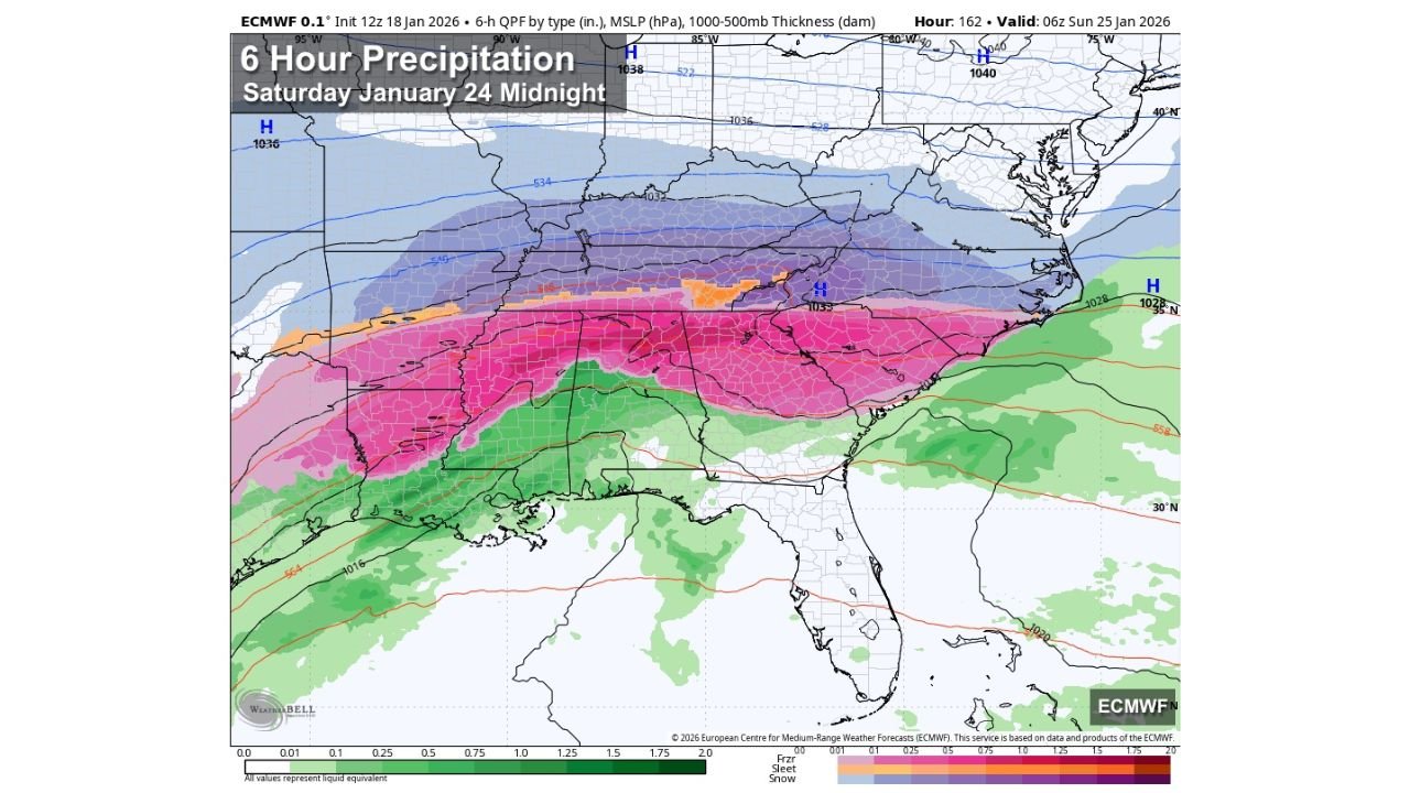
Recent high-resolution European model runs suggest the northern half of Alabama, along with parts of middle Tennessee, northern Georgia, and western South Carolina, could see an extended window of freezing rain if surface temperatures remain locked below freezing.
In this scenario:
- Rain develops aloft while surface temperatures hover at or below 32°F
- Liquid rain freezes on contact with roads, bridges, trees, and power lines
- Ice accumulation becomes possible even without heavy precipitation
Some guidance also introduces snow and sleet mixing in, particularly along the northern edge of the system.
Why Forecast Confidence Is Still Limited
Despite the concerning signals, meteorologists stress that forecast confidence remains moderate at best. One key uncertainty is low-level atmospheric thickness values, which currently sit near the margin between cold rain and freezing rain.
If temperatures rise just a degree or two:
- Impacts could be limited to cold, wet conditions
- Ice accumulation would be minimal or nonexistent
If colder air holds:
- Ice accretion could become significant
- Travel disruptions and power outages would become more likely
Because of this razor-thin margin, officials caution against locking in specifics too early.
Timing: When the Window of Risk Opens
Based on current projections:
- Friday night: Cold air strengthens across the region
- Saturday into early Sunday: Primary window for freezing rain, sleet, or snow
- Sunday afternoon: System gradually exits, though lingering impacts may remain
Forecasters expect sharper clarity by Wednesday, with a more definitive forecast likely by Thursday.
Travel and Infrastructure Impacts Remain a Wild Card
At this stage, there is no reliable way to predict exact road conditions, but even light ice accumulation can rapidly create dangerous travel conditions across the Southeast, where winter weather infrastructure is limited.
Potential impacts include:
- Slick roads and bridges
- Reduced visibility during heavier precipitation bands
- Tree damage and isolated power outages if icing becomes significant
What Residents Should Do Now
Officials recommend using the next several days to:
- Monitor updated forecasts daily
- Review cold-weather safety plans
- Prepare for possible travel disruptions
- Avoid unnecessary weekend travel if ice becomes likely
This system may still trend weaker — or shift north or south — but the signal for a meaningful winter weather threat remains on the table.
More updates and detailed breakdowns will follow as confidence improves. Stay alert, stay prepared, and continue tracking updates right here on Waldron News as this late-January winter threat evolves.