
Michigan and Indiana Brace for Major Lake-Effect and System Snow as Foot-Plus Totals Threaten Areas West of US-131
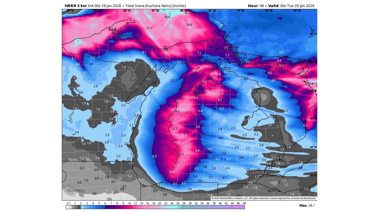
UNITED STATES — A powerful and increasingly confident winter storm signal is coming into focus across the Great Lakes, with parts of western Michigan and northern Indiana facing the potential for significant, disruptive snowfall through Monday evening. Latest high-resolution guidance suggests multiple locations west of U.S. Route 131 could approach or exceed one foot of snow, a level that would likely force school closures, hazardous travel, and widespread delays.
Forecasters emphasize that while exact totals will still fluctuate, the overall setup now strongly favors a high-impact winter event, particularly in traditional lake-effect corridors.
Why This Storm Has Become a Serious Concern
Recent model runs show a strengthening combination of deep cold air, persistent northwest flow, and long lake fetch off Lake Michigan. This pattern is well-known for producing narrow but intense snow bands that can sit over the same communities for hours.
In this case, guidance shows a well-organized snow axis developing from southwest Michigan into parts of northern Indiana, with snowfall rates capable of overwhelming road crews during peak periods.
Key factors driving the threat include:
- Strong lake-effect enhancement as Arctic air pours across relatively warmer lake waters
- Slow-moving snow bands, increasing the risk of extreme local totals
- Cold temperatures, allowing high snow-to-liquid ratios and rapid accumulation
Where the Heaviest Snow Is Most Likely
The highest confidence zone for disruptive snowfall currently includes:
- Western Michigan, especially counties west of US-131
- Portions of southwest and north-central Michigan
- Localized areas of northern Indiana, closer to Lake Michigan
Some guidance depicts 10 to 14 inches in favored bands, with isolated higher totals possible if band placement remains persistent.
Just a few miles outside the core snow bands, totals may drop sharply — a hallmark of lake-effect events — making local forecasting and nowcasting critical.
Timing: When Conditions Will Deteriorate
Snow is expected to intensify Sunday night, continuing into Monday, with the worst travel conditions likely during the Monday morning and midday hours.
By Monday evening:
- Snow-covered and icy roads are likely in hardest-hit areas
- Visibility may drop rapidly under heavier bands
- Emergency and school officials may opt for closures or delayed operations
Travel, School, and Community Impacts
Given the projected totals and snow rates, impacts could include:
- Multiple school closures or remote learning days
- Dangerous travel, especially on north-south roads crossing lake-effect bands
- Stranded vehicles and accidents during heavier bursts
- Slower emergency response times in rural areas
Residents are urged to avoid unnecessary travel, ensure vehicles are winter-ready, and closely monitor local alerts.
Forecast Confidence and Remaining Uncertainty
While confidence is increasing that a major snow event will occur somewhere in the region, exact placement of the heaviest snow remains uncertain. A shift of even 10–20 miles in band position could drastically change local outcomes.
Forecasters stress that updates will continue, and residents should rely on local National Weather Service offices and emergency managers for the most accurate, location-specific information.
What Residents Should Do Now
- Prepare for powerful winter conditions, especially west of US-131
- Have extra food, medications, and supplies on hand
- Plan for school or work disruptions Monday
- Keep devices charged and weather alerts enabled
This developing storm has the potential to become one of the most impactful snow events of the season for parts of Michigan and Indiana.
Stay alert, stay prepared, and continue checking WaldronNews.com for the latest updates as this winter storm unfolds.