
Ohio and Indiana Face Bitter Cold, Dangerous Wind Chills, and Light Snow as Arctic Air Tightens Grip Tonight
UNITED STATES — A surge of Arctic air is settling firmly across Ohio and eastern Indiana tonight, bringing dangerously cold wind chills, periods of light snow, and travel concerns that will extend into early Monday. Forecasters warn that this will be one of the coldest stretches so far this winter, with the most severe conditions arriving overnight and lingering through Tuesday.
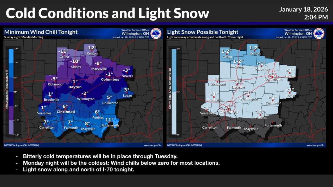
Wind Chills Drop Below Zero Across Much of Ohio
The most immediate concern tonight is the rapid drop in wind chill values as strong Arctic air pours into the region. Forecast maps show wind chills falling below zero across a large portion of Ohio, with the coldest readings expected in central and northern counties.
Areas near Dayton, Columbus, Marysville, Sidney, Kenton, and Celina could see wind chills ranging from -8°F to -12°F overnight. Even locations farther south, including Cincinnati and Wilmington, are expected to experience wind chills near or just below zero by Monday morning.
These conditions significantly increase the risk of frostbite and hypothermia, especially for anyone spending extended time outdoors without proper protection.
Light Snow Possible Along and North of I-70
In addition to the bitter cold, light snow is expected tonight, mainly along and north of the Interstate 70 corridor. Forecast guidance indicates that most areas will see less than one inch of accumulation, though parts of north-central Ohio could receive 1 to 2 inches before the snow tapers off.
Cities such as Columbus, Dayton, Sidney, Kenton, and Celina sit within the zone where light accumulations are most likely. While snowfall totals are not expected to be significant, even a small amount of snow can create slick road conditions when combined with rapidly falling temperatures.
Monday Night Expected to Be the Coldest Period
Forecasters emphasize that Monday night will be the coldest stretch of this Arctic outbreak. Wind chills are expected to drop even further, with many locations across Ohio and eastern Indiana experiencing sub-zero wind chills for several hours.
Temperatures will struggle to recover during the day Monday, and the persistent cold will allow any untreated roadways, sidewalks, and parking lots to remain icy well into Tuesday morning.
Cold Air Holds Firm Through Tuesday
This Arctic air mass is not a quick-moving system. Bitterly cold temperatures are expected to remain in place through Tuesday, keeping wind chills uncomfortably low and increasing stress on heating systems, pets, livestock, and vulnerable populations.
Residents are urged to limit time outdoors, dress in multiple warm layers, cover exposed skin, and ensure pets are brought indoors or provided with adequate shelter.
What Residents Should Do Now
• Prepare for dangerously cold wind chills tonight and Monday
• Use caution on roads, especially where light snow and refreezing may occur
• Check on elderly neighbors and those without reliable heating
• Bring pets indoors and protect exposed pipes from freezing
Cold weather impacts can escalate quickly when Arctic air takes hold. Conditions will be closely monitored, and additional updates will be provided as new information becomes available.
Stay safe, stay warm, and continue following updates on WaldronNews.com for the latest winter weather coverage.