
North Carolina and South Carolina Face Rare All-Snow Winter Storm as Weekend Snow Probabilities Surge Into the 80–90% Range
UNITED STATES — Forecast confidence is rapidly increasing that a rare, all-snow winter storm will impact large portions of North Carolina and South Carolina from late Friday through the weekend, with ensemble guidance now showing very high probabilities of measurable snowfall across much of the Carolinas.
Meteorological data indicates this will be a cold-air dominated system, significantly reducing the risk of rain or mixed precipitation and increasing confidence that snow will be the primary precipitation type throughout the event.
High Confidence in Measurable Snowfall Across the Carolinas
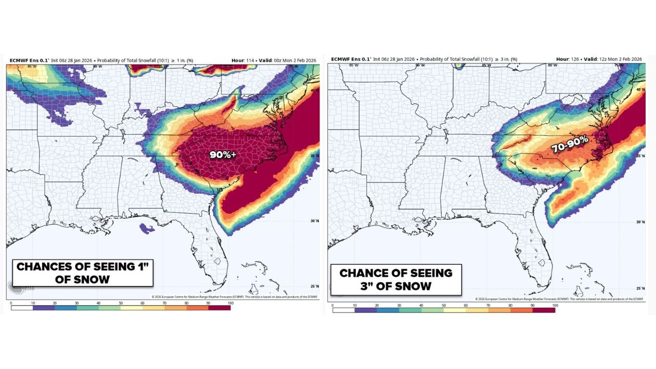
Ensemble snowfall probability maps show a strong signal for at least 1 inch of snow across central and eastern sections of both states.
- Central and eastern North Carolina: Snow probabilities exceed 80–90%
- Much of South Carolina: Widespread 80–90% chance of seeing at least 1 inch
- Western Carolinas and foothills: Lower probabilities, generally 10–30%, tapering westward
This probability distribution suggests the highest confidence zone extends from the Charlotte metro eastward through the Piedmont and Coastal Plain, including areas near Raleigh, Fayetteville, Florence, and Wilmington.
Increasing Signal for Higher Snow Totals
While forecasters caution it is still too early to lock in exact accumulation totals, probabilities for higher snowfall amounts are also increasing.
- The chance of seeing 3 inches of snow reaches 70–90% across portions of central and eastern North Carolina
- South Carolina shows a growing corridor of moderate to high probabilities for 3 inches, especially inland from the coast
These probabilities reflect ensemble agreement, a key indicator that the storm’s structure is becoming better resolved in forecast models.
Cold Air Profile Supports Straight Snow
Forecast guidance highlights a firm cold-air presence throughout the event, strongly favoring snow rather than a messy rain-snow mix.
- No significant warm layer is indicated in the lower atmosphere
- Thermal profiles support snowfall from start to finish
- This setup increases confidence in accumulation efficiency, even at lower elevations
This type of setup is considered uncommon for the Carolinas, particularly when confidence is this high several days in advance.
Timing: Late Friday Through Saturday, Lingering Into Monday
Current data places the primary impact window from very late Friday into Saturday, with lingering effects possible into early Monday morning.
- Snow may begin late Friday night
- Peak impacts are expected Saturday
- Cold conditions could allow snow and ice to linger into Monday
Exact start and end times will be refined as the event approaches.
Impact Outlook and Next Steps
Based on current data:
- Moderate travel disruptions are possible across much of NC and SC
- Local impacts could escalate if higher snowfall probabilities verify
- Forecast confidence is still increasing, not decreasing
Forecasters are expected to release initial snowfall accumulation maps (“First Call” guidance) as early as tonight or early Thursday, which will provide more precise expectations.
WaldronNews Weather Update
This system continues to trend stronger in forecast guidance. Residents across North Carolina and South Carolina should closely monitor updates and prepare for potential winter weather impacts this weekend.
Stay connected with WaldronNews for refined snowfall forecasts, updated timelines, and impact-focused coverage as new data arrives.