
Georgia Snow Threat Intensifies This Weekend as Eastern Counties Face High Odds of Travel Disruptions While Atlanta Watches the Track
UNITED STATES — A developing winter weather system is expected to bring snow-related travel problems to parts of Georgia this weekend, with the highest risk concentrated across eastern Georgia, according to updated winter weather impact probabilities.
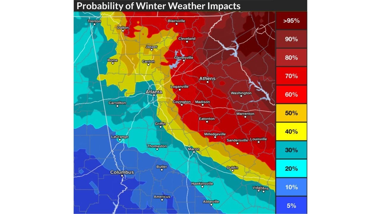
While snowfall amounts remain uncertain, forecast guidance now shows moderate to high confidence for at least minor winter impacts, especially east of the Atlanta metro area.
Snow Returns to Georgia With Eastern Counties at Highest Risk
Forecast data indicates that snow will return to portions of Georgia, with the greatest likelihood of travel issues stretching from northeast Georgia through central and east-central counties.
Areas highlighted for elevated impact potential include:
- Athens, Gainesville, Washington, Madison, Warrenton, Sandersville, and Milledgeville
- A broad corridor east of Atlanta showing 60% to greater than 90% odds of winter travel impacts
- Localized pockets exceeding 95% probability in far eastern Georgia
These probabilities point to a strong signal for hazardous road conditions, even where snowfall totals remain modest.
Atlanta Impact Risk Remains Uncertain but Not Zero
For the Atlanta metro, forecast confidence is lower.
- Impact probability near Atlanta is roughly 30–40%
- This equates to about a one-in-three chance of minor winter impacts
- Outcomes depend heavily on how far west the storm track shifts
A slight westward adjustment could increase risks, while an eastward track would spare much of the metro.
This Will Be an All-Snow Event
Meteorologists emphasize that this system is expected to fall entirely as snow, not freezing rain or sleet.
- No ice accumulation is anticipated
- Main concern is snow-covered roads, not power-line icing
- Cold temperatures will allow snow to accumulate quickly if bands persist
Even light to moderate snowfall can cause outsized impacts in areas unaccustomed to winter weather.
What the Impact Map Really Shows
The probability graphic focuses on disruptions to daily life, not just snowfall totals. That includes:
- Slippery roads and bridges
- Slowed or hazardous travel
- Potential delays for weekend plans
Eastern Georgia stands out clearly as the most vulnerable region, while western Georgia remains at lower risk.
What Happens Next
Forecasters continue to monitor:
- Final storm track placement
- Duration of snowfall Saturday
- Whether impact probabilities expand westward toward Atlanta
Updates are expected as the weekend approaches.
WaldronNews Weather Update
Georgia is facing a legitimate winter travel risk this weekend, with eastern counties showing the highest odds of disruption, while Atlanta remains on the edge of potential impacts depending on the storm’s final track.
Stay with WaldronNews for continued updates as confidence increases and timing becomes clearer.