
North Carolina, South Carolina, Georgia and Virginia Brace for Major Snowstorm as 6z Euro Shifts Track, Boosting Heavy Snow Potential Across Appalachians and Piedmont
SOUTHEASTERN UNITED STATES —Forecast confidence has increased significantly that a high-impact winter storm will affect large portions of North Carolina, South Carolina, northeast Georgia, southwest Virginia, and southeast Virginia from late Friday through Sunday, following a notable shift in the latest 6z ECMWF (Euro) model.
The newest guidance shows a slightly more negative tilt in the upper-level low, a change that meteorologists say can dramatically increase snowfall totals across the Southern Appalachians, Upstate South Carolina, western North Carolina, and parts of central North Carolina. Even small adjustments in the storm’s track are now producing major differences in accumulation, particularly west of the I-85 corridor.
Model Shift Increases Snow Totals in the Carolinas and Southern Appalachians
According to the updated Euro snowfall projection, western North Carolina (WNC) and adjacent regions of Upstate South Carolina and northeast Georgia are now firmly within the heaviest snow band.
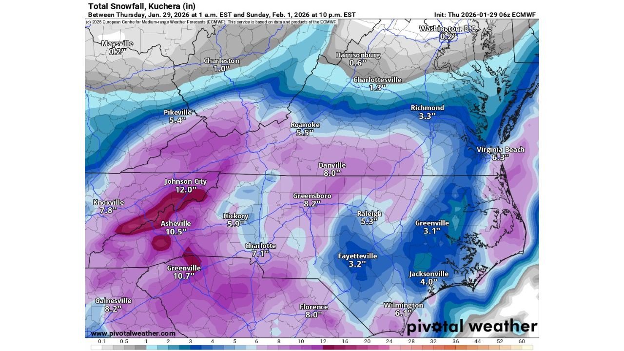
Projected storm-total snowfall amounts include:
- Johnson City, TN: around 12 inches
- Asheville, NC: 10–11 inches
- Greenville, SC: 10+ inches
- Charlotte, NC: 6–8 inches
- Greensboro, NC: around 8 inches
- Florence, SC: near 8 inches
- Raleigh, NC: 5 inches
- Virginia Beach, VA: 6 inches
- Roanoke, VA: 5–6 inches
Lower but still disruptive totals are expected across eastern North Carolina and southeast Virginia, where colder air arriving faster than earlier forecasts supports mainly snow instead of mixed precipitation.
Winter Storm Watch Issued as Travel Conditions Deteriorate
A Winter Storm Watch has been issued across much of western and central North Carolina, Upstate South Carolina, and southwest Virginia, valid from Friday afternoon through Saturday night. Forecasters warn that significant snowfall rates, combined with persistently cold surface temperatures, will lead to dangerous travel conditions.
Even ahead of the storm, a prolonged cold wave continues to grip the region, with temperatures running 10 to 20 degrees below normal, increasing the risk of black ice, especially during morning and overnight hours.
Arctic Cold to Follow Snowfall, Increasing Risk
Behind the storm, Arctic air is expected to surge back into the region. Wind chills are forecast to drop near zero across much of the Tennessee Valley and southern Appalachians, with 10 to 20 degrees below zero possible in higher elevations.
The combination of heavy snow, gusty winds, and extreme cold raises concerns for:
- Extended road closures
- Power disruptions in higher terrain
- Hazardous conditions for anyone stranded outdoors
Forecast Confidence Rising, But Track Still Critical
While confidence is growing that a significant snow event will occur, forecasters stress that small changes in the storm’s path could still shift the axis of heaviest snow east or west by 50–75 miles. Areas along the current gradient zones, including parts of the North Carolina Piedmont and eastern Carolinas, should closely monitor updates.
What Residents Should Do Now
- Avoid unnecessary travel from Friday evening through Saturday
- Prepare for power outages in higher elevations
- Protect pipes, pets, and vulnerable populations from extreme cold
- Stay updated as warnings may replace watches in coming forecast cycles
This remains a developing situation. WaldronNews will continue tracking updates as confidence and details evolve.
Share your local conditions and preparations with us, and stay connected with WaldronNews for the latest winter storm coverage across the Southeast.