
Virginia Winter Storm Watch Issued as Powerful Snow, Strong Coastal Winds, and Flooding Threats Loom Through Sunday
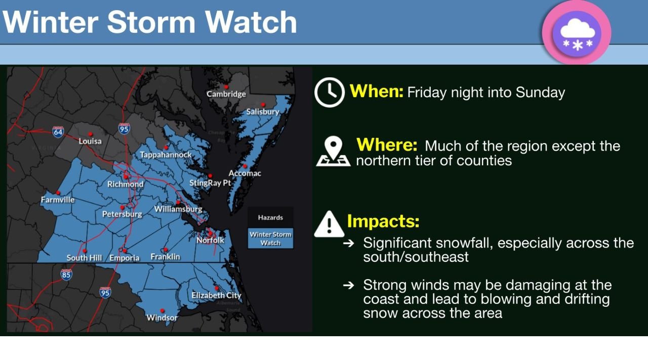
VIRGINIA — A Winter Storm Watch has been issued for large portions of eastern and southeastern Virginia as a strong winter system is expected to impact the region from Friday night through Sunday, according to the National Weather Service office in Wakefield.
Forecasters warn that significant snowfall, damaging winds, coastal flooding, and dangerously cold temperatures are all possible as the storm develops, with the highest impacts expected across southern and southeastern counties.
Winter Storm Watch Covers Most of Eastern and Southeastern Virginia
The Winter Storm Watch includes much of the region, excluding only the northern tier of counties. Areas under the watch span inland communities as well as coastal and Tidewater locations, where impacts could be more severe due to strong winds and proximity to the coastline.
Cities and surrounding areas within the watch include parts of central Virginia, Southside Virginia, Hampton Roads, the Middle Peninsula, and the Eastern Shore, based on the highlighted zones in the National Weather Service map.
Timeline: Storm Expected Friday Night Through Sunday
According to the forecast timeline provided by the National Weather Service:
- Storm onset: Friday night
- Peak impacts: Saturday into early Sunday
- Storm exit: Sunday
This extended duration increases the likelihood of accumulating snowfall, ongoing blowing and drifting snow, and compounding travel and infrastructure issues across the region.
Significant Snowfall Likely, Especially in the South and Southeast
Meteorologists indicate that significant snowfall is a primary concern, particularly across southern and southeastern Virginia. While exact snowfall totals have not yet been finalized, the watch signals the potential for impactful winter conditions, not just light or nuisance snow.
The longer the storm persists, the greater the risk of road closures, hazardous travel conditions, and disruptions to daily activities.
Strong Coastal Winds May Cause Blowing Snow and Damage
Another major concern highlighted in the data is strong winds, especially along coastal areas. These winds could:
- Reduce visibility due to blowing and drifting snow
- Increase the risk of isolated property damage
- Exacerbate already dangerous travel conditions
Coastal communities may experience stronger gusts, which can worsen conditions even in areas with lower snowfall totals.
Coastal Flooding and Dangerous Cold Also Expected
In addition to snow and wind, the National Weather Service notes the potential for:
- Coastal flooding, particularly during high tide cycles
- Very cold temperatures, which may follow or accompany the storm
Cold air moving in behind the system could lead to prolonged icy conditions, increasing the risk of refreezing on untreated roads and sidewalks.
What a Winter Storm Watch Means for Residents
A Winter Storm Watch indicates that hazardous winter weather is possible, but details such as exact snowfall totals and wind strength may still change. Residents in the watch area are urged to:
- Monitor updated forecasts and alerts
- Prepare for possible travel disruptions
- Secure loose outdoor items in wind-prone areas
- Plan for cold temperatures and potential power issues
The watch may be upgraded to a Winter Storm Warning if confidence in severe impacts increases.
Stay with WaldronNews for ongoing updates as this winter storm threat evolves and additional advisories or warnings are issued for Virginia and surrounding regions.