
Mid-Atlantic Winter Storm Forecast Brings Up to 5 Inches of Snow From Virginia to New England Through February 1
UNITED STATES — A developing winter weather system is expected to bring accumulating snowfall across large portions of the Mid-Atlantic and Northeast between Thursday night, January 29, and Sunday evening, February 1, 2026, according to the latest National Weather Service (NWS) Mid-Atlantic River Forecast Center outlook.
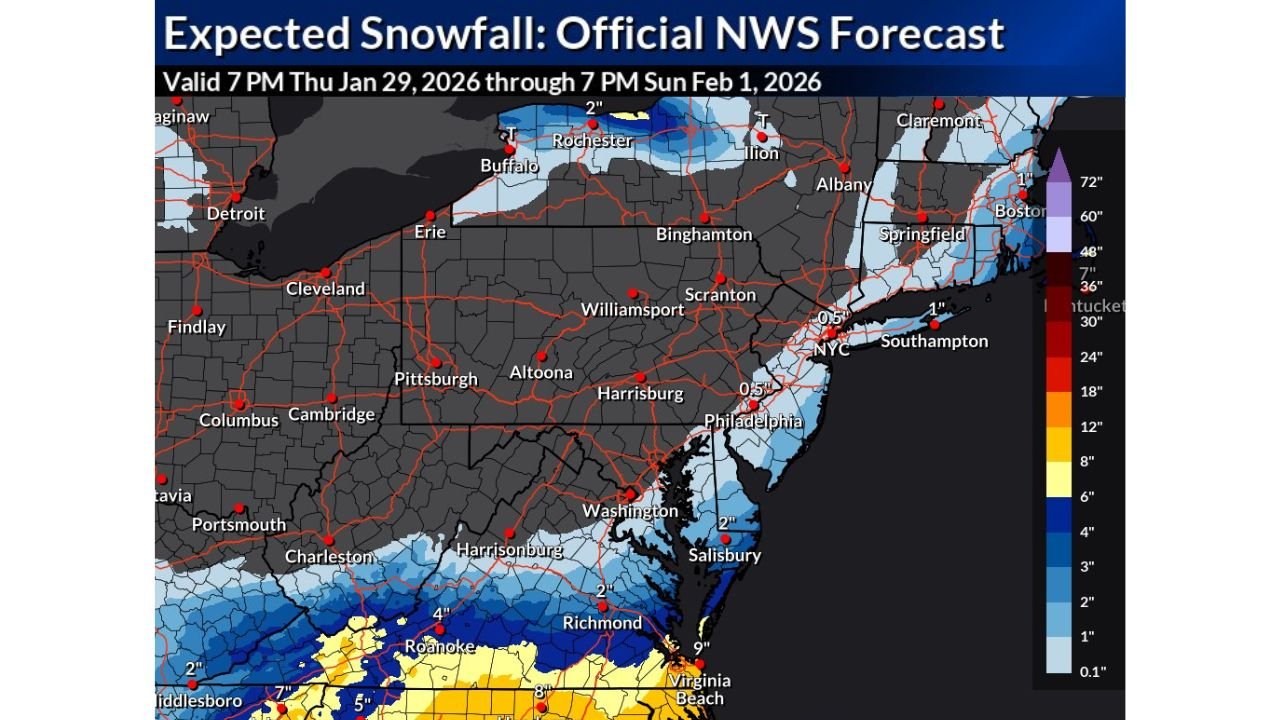
The official snowfall forecast shows widespread light to moderate snow totals, with localized higher amounts across southern Virginia, parts of North Carolina, and interior New England as colder air pushes southward behind the system.
Snowfall Timeline and Forecast Window
The NWS forecast is valid from 7 PM Thursday, January 29, through 7 PM Sunday, February 1, covering a multi-day winter event rather than a single overnight storm.
Forecasters note that snowfall will occur in waves, with periods of lighter snow followed by brief heavier bursts as the system tracks along the East Coast.
Areas Expected to See the Highest Snow Totals
Based on the official snowfall map:
- Southern Virginia and northern North Carolina could see 4 to 9 inches of snow, especially near and south of the Roanoke and Virginia Beach corridors.
- Central Virginia, including areas near Richmond, is forecast to receive around 2 inches.
- Maryland’s Eastern Shore, including Salisbury, is projected to see around 2 inches of accumulation.
- Interior sections of New England, including parts of Massachusetts and upstate New York, may see 1 to 2 inches, with slightly higher totals in localized bands.
Lighter Snow Expected in Major Metro Areas
Major cities along the I-95 corridor are expected to see lighter accumulations, but impacts are still possible:
- Washington, D.C.: Light snow, generally under 1 inch
- Philadelphia: Around 0.5 inches
- New York City: Around 0.5 inches
- Boston and surrounding areas: Light snow, generally 1 inch or less
Even small accumulations could create slick roads and travel slowdowns, especially during overnight and early-morning hours.
Why Snow Totals Vary Sharply Across the Region
The sharp cutoff in snowfall amounts is due to:
- Temperature differences near the coast
- Cold air funneling southward from the Northeast
- Moisture concentration farther inland, particularly across Virginia and North Carolina
This setup favors heavier snow inland, while coastal areas remain closer to the rain-snow line.
What This Means for Arkansas and the South-Central U.S.
While Arkansas — including Waldron and Scott County — is not included in this snowfall forecast, the system highlights a broader late-January winter pattern that continues to send cold air deep into the eastern United States.
Meteorologists note that similar upper-level patterns could influence future southern systems, and residents should continue monitoring updated forecasts as February approaches.
Travel and Safety Considerations
Residents and travelers across the Mid-Atlantic and Northeast should:
- Monitor local NWS updates for changes in snowfall totals
- Prepare for slick roads, especially overnight
- Allow extra travel time where snow is expected to accumulate
Stay informed with WaldronNews for continued winter weather coverage, regional forecasts, and updates on how national weather patterns could impact Arkansas in the days ahead.