
Forecast Tracks Show Arctic Air Streaming Directly From the North Pole to South Florida, Setting Up an Extremely Cold and Dry Outbreak
UNITED STATES — Meteorologists are closely watching a rare and striking Arctic air intrusion expected to surge from the polar region straight into the southeastern United States, with forecast trajectory data showing air traveling from near the North Pole all the way to South Florida with very little time spent over open water.
The setup is expected to deliver exceptionally cold, dry, and gusty conditions late Saturday into Sunday morning, driven by a rapidly intensifying low-pressure system offshore of the Southeast U.S.
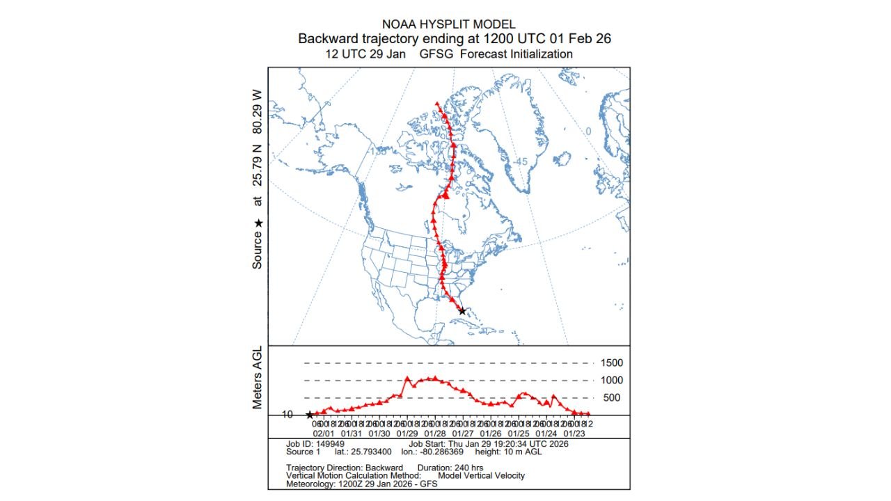
What the Trajectory Data Reveals
The NOAA HYSPLIT backward-trajectory model traces the origin of the incoming air mass back nearly in a straight line from the high Arctic, moving southward through central Canada, the central United States, and directly into Florida.
Key takeaways from the trajectory graphic include:
- Air originating deep in the polar region
- A nearly north-to-south path, minimizing modification
- Little time over oceans or warm surfaces, preserving extreme cold and dryness
- Arrival near southern Florida by early Sunday
This type of trajectory is highly unusual, especially for late January air reaching so far south.
Why This Pattern Produces Extreme Cold and Dryness
Because the air mass spends minimal time over warm water, it does not pick up moisture or heat along the way.
As a result:
- Temperatures drop sharply, even in areas unaccustomed to Arctic air
- Humidity levels plunge, creating very dry conditions
- Winds increase as pressure gradients tighten behind the storm system
Meteorologists note that dry Arctic air often feels harsher than wetter cold, contributing to rapid heat loss and dangerous wind chills.
Role of the Offshore Low-Pressure System
A rapidly strengthening low-pressure system offshore of the Southeast coast is acting as the engine pulling this air mass southward.
This system is expected to:
- Accelerate cold air movement into the Southeast
- Produce strong, gusty winds
- Lock the Arctic air in place for several hours to days
The result is a brief but intense cold surge, rather than a slow moderation.
Potentially Historic Cold for Parts of the Southeast
Forecasters caution that while exact temperature records depend on local conditions, the combination of air origin, dryness, and wind makes this outbreak potentially one of the coldest and driest events in recent decades for parts of the Deep South.
Even locations like South Florida, which rarely experience Arctic air of this origin, may feel conditions far colder than typical winter norms.
Why This Event Is Meteorologically Significant
Events like this stand out because:
- True polar air masses rarely penetrate this far south
- Straight-line Arctic trajectories are uncommon
- The lack of moisture limits cloud cover, enhancing nighttime cooling
Together, these factors create near-textbook Arctic outbreak conditions across a wide portion of the eastern United States.
What This Means for Arkansas
While Arkansas will not experience the same extreme southern reach of this air mass, the broader pattern underscores a high-amplitude winter setup, capable of producing sharp temperature swings and fast-moving cold fronts.
Such patterns can continue to influence the South-Central U.S., keeping winter weather risks elevated.
Stay with WaldronNews for continued coverage of this Arctic outbreak, national weather pattern analysis, and updates on how evolving conditions could impact Arkansas next.