
Weekend Snowstorm Forecast Hinges on Subtle Warm-Front Shift, Creating High-Risk Uncertainty for North Carolina and the Mid-Atlantic
UNITED STATES — Forecast confidence remains unusually fragile heading into the weekend as meteorologists warn that a narrow, elevated warm front ahead of the main upper-level trough could dramatically alter snowfall outcomes, especially across central North Carolina, including the Raleigh area, and parts of the Mid-Atlantic.
Multiple high-resolution model depictions show that small changes in the strength or placement of this warm front early Saturday could mean the difference between a plowable snow and a near-miss, underscoring why snowfall maps remain volatile despite strong signals for cold air and an active storm track.
Why This Warm Front Matters More Than Usual
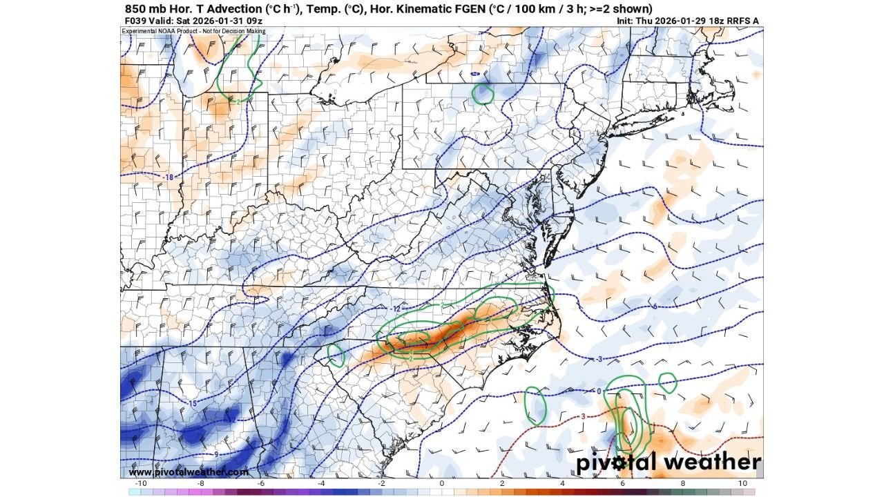
At the heart of the forecast challenge is an 850-mb warm advection zone setting up ahead of the primary trough. This feature is elevated — not surface-based — which means temperatures a few thousand feet above ground may briefly rise even while surface air stays cold.
If that warm layer strengthens or nudges northward:
- Snow may weaken or mix, especially south of the Virginia border
- Lift and frontogenesis (FGEN) could shift east, pulling heavier snow bands toward the coast
If it stays weaker or farther south:
- Strong deformation and FGEN could lock in over central North Carolina
- Raleigh and surrounding areas could see a substantially higher snow total
This is why forecasters stress that the model handling of this feature “makes or breaks” the weekend forecast.
Model Disagreements Highlight the Risk
Current guidance illustrates the knife-edge nature of the setup:
- Some solutions show a compact, intense snow band forming along the warm front, favoring central NC into southeast Virginia
- Other runs displace that band east, limiting inland snow while boosting totals closer to the coast
Because snowfall rates within these bands can be heavy, even a 30–50 mile shift could produce drastically different local outcomes.
This type of setup is notorious for sharp cutoffs, where one county sees several inches while a neighboring area sees far less.
Arctic Air Is Not the Question — It’s Locked In
While precipitation placement is uncertain, the cold air supply is not.
Air-mass trajectory data shows a direct feed of Arctic air plunging south from near the polar regions, with very little modification over water. This supports:
- Very cold surface temperatures
- High snow-to-liquid ratios
- A storm capable of producing efficient snowfall wherever lift is strongest
In short: if snow develops, it will accumulate quickly.
What Residents Should Expect Right Now
- Expect forecast adjustments through Friday and early Saturday
- Snowfall maps will likely shift north or south, not disappear
- Areas near the warm-front boundary face the highest boom-or-bust risk
Forecasters urge residents not to focus on a single model or map, but instead prepare for rapid updates as the event draws closer.
Bottom Line
This is a classic high-impact, low-confidence winter setup where subtle atmospheric details matter enormously. The presence of deep cold ensures winter weather potential is real — but the final snow footprint won’t be clear until the warm-front placement is resolved.
WaldronNews will continue tracking model trends and issue updates as confidence improves.
Stay with WaldronNews for the latest forecast updates, localized impacts, and safety guidance as this weekend system approaches.