
First-Ever Extreme Cold Watch Issued for Central Florida as Historic Arctic Air Brings Hard Freeze and Single-Digit Wind Chills
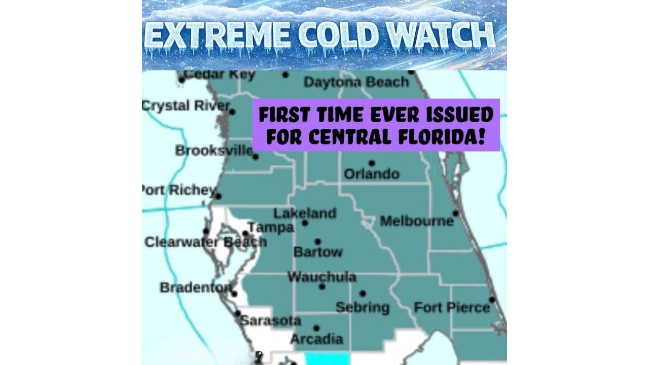
UNITED STATES — For the first time on record, the National Weather Service has issued an Extreme Cold Watch for Central Florida and the Tampa Bay area east of I-75, signaling a rare and potentially historic cold outbreak expected to peak late Saturday night into early Sunday morning.
Forecast data shows Arctic air plunging directly into the Florida Peninsula, setting the stage for dangerously cold temperatures, unusually strong winds, and wind chills rarely — if ever — experienced in this region.
What an Extreme Cold Watch Means for Florida
An Extreme Cold Watch is rarely used in Florida and is reserved for situations where life-threatening cold conditions are possible, especially in regions unaccustomed to prolonged freezing temperatures.
For this event, forecasters are highlighting:
- Overnight lows near 20°F in parts of Central Florida
- Wind chills as low as 8°F due to persistent north winds
- A hard freeze capable of damaging pipes, crops, and exposed infrastructure
Meteorologists stress that this is not a typical Florida cold snap, but a high-impact Arctic intrusion more common in the central United States.
Why This Cold Outbreak Is So Extreme
Atmospheric trajectory analysis shows air flowing nearly straight from the polar regions into Florida, with minimal warming over water. This allows the cold air to retain its intensity all the way to the Gulf Coast and central peninsula.
Key factors making this event exceptional:
- Direct Arctic air delivery, not modified by the Gulf or Atlantic
- Rapidly strengthening offshore low pressure, tightening the pressure gradient
- Strong, sustained winds, dramatically lowering wind chill values
This combination explains why forecasters are using historic language when describing the event.
Areas Most at Risk
The Extreme Cold Watch covers much of Central Florida, including:
- The Tampa Bay metro east of I-75
- Interior counties around Lakeland, Bartow, Wauchula, Sebring, and Arcadia
- Portions of inland east-central Florida where radiational cooling will be strongest
Coastal locations may stay slightly warmer, but cold winds will still make conditions dangerous, especially overnight.
Impacts Residents Should Prepare For
Residents are urged to prepare for:
- Frozen or burst pipes in homes not designed for prolonged freezes
- Severe damage to crops and sensitive vegetation
- Dangerous exposure risks for anyone outdoors overnight
- Unprecedented stress on pets, livestock, and outdoor animals
Officials strongly recommend protecting plumbing, bringing pets indoors, checking on vulnerable neighbors, and avoiding prolonged outdoor exposure.
Bottom Line
This Arctic outbreak is exceptional by Florida standards, and the issuance of a first-ever Extreme Cold Watch for Central Florida underscores the seriousness of the threat. With hard freeze conditions and single-digit wind chills possible, this event has the potential to set records and cause widespread impacts.
WaldronNews will continue to monitor updates as watches transition to warnings and will provide additional guidance as confidence increases.
Stay with WaldronNews for critical cold-weather updates, safety tips, and breaking forecast changes as this rare Florida freeze unfolds.