
New York and Long Island Snow Threat Fades as Cold Advisories Continue and Strong Coastal Winds Build
NEW YORK — Cold weather advisories remain in effect across the region Saturday morning, but the threat of accumulating snow is rapidly decreasing as the latest National Weather Service data shows most of the area will see little to no snowfall heading into Sunday.
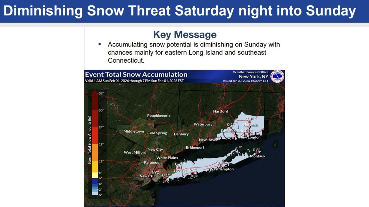
Forecasters now say the highest — and still limited — snow potential is confined to eastern Long Island and southeast Connecticut, where amounts are expected to stay under one inch. For much of New York City, northern New Jersey, and interior southern New England, snow is increasingly unlikely.
Snow Chances Continue to Shrink for Most of the Region
According to the latest forecast briefing from the National Weather Service in New York, the system expected Saturday night into Sunday has shifted farther offshore, significantly reducing snow coverage inland.
- Most of the region: No measurable snow
- Eastern Long Island & southeast Connecticut: Light snow possible
- Expected totals: Under 1 inch, even in favored areas
Forecasters note that a northwest shift in the precipitation shield could slightly increase snowfall totals, but this scenario is becoming less likely with each update. A southeast shift would result in no snow at all for nearly the entire region.
Cold Weather Advisories Extended Through Saturday Morning
While snow chances fade, cold remains the primary concern. Cold weather advisories have been extended through 10 a.m. Saturday, with temperatures well below seasonal averages early in the day.
Residents are urged to take precautions for:
- Prolonged exposure outdoors
- Vulnerable populations
- Pets and unprotected plumbing
Even as temperatures moderate slightly later Saturday, conditions will remain cold enough overnight to support snow or a brief wintry mix — if precipitation occurs at all.
Strong Winds and Coastal Impacts Take Center Stage Sunday
As the system passes offshore, wind becomes the bigger issue, particularly near the coast.
- North winds: 15–25 mph
- Wind gusts: Up to 35–45 mph, mainly along the coast
- Marine impacts: Gale Watch in effect from 12 a.m. to 6 a.m. Sunday
These winds could lead to minor coastal flooding during high tide Sunday and Sunday night, along with localized shoreline impacts, especially along exposed coastal areas of Long Island.
Bottom Line: Cold and Windy, But Snow Is No Longer the Main Story
Forecasters stress that while this system once showed greater wintry potential, the threat has steadily diminished. Any snow that does fall late Saturday night into Sunday should be light, brief, and highly localized.
The primary impacts for the region now center on:
- Cold temperatures
- Strong coastal winds
- Minor coastal flooding risks
Stay with WaldronNews.com for continued winter weather updates, forecast shifts, and real-time alerts as conditions evolve across the Northeast and beyond.