
Ohio, Indiana, and Northern Kentucky Face Renewed Snow Risk as Slick Conditions Develop Thursday Night Into Friday
OHIO — After a brief stretch of dry and calmer weather, another round of winter conditions is setting up across Ohio, eastern Indiana, and northern Kentucky, with snow showers expected to move in late Thursday night and continue into Friday evening. Forecasters warn that even light snowfall could quickly lead to slick roads as temperatures drop rapidly after dark.
Dry Midweek Before Conditions Change
According to the National Weather Service in Wilmington, dry conditions are expected to hold across much of the region through Wednesday and most of Thursday. This short break will allow roadways to improve following recent winter weather, but officials caution that conditions will deteriorate again heading into the end of the week.
Temperatures are expected to remain cold enough that any new snowfall will stick quickly once it begins.
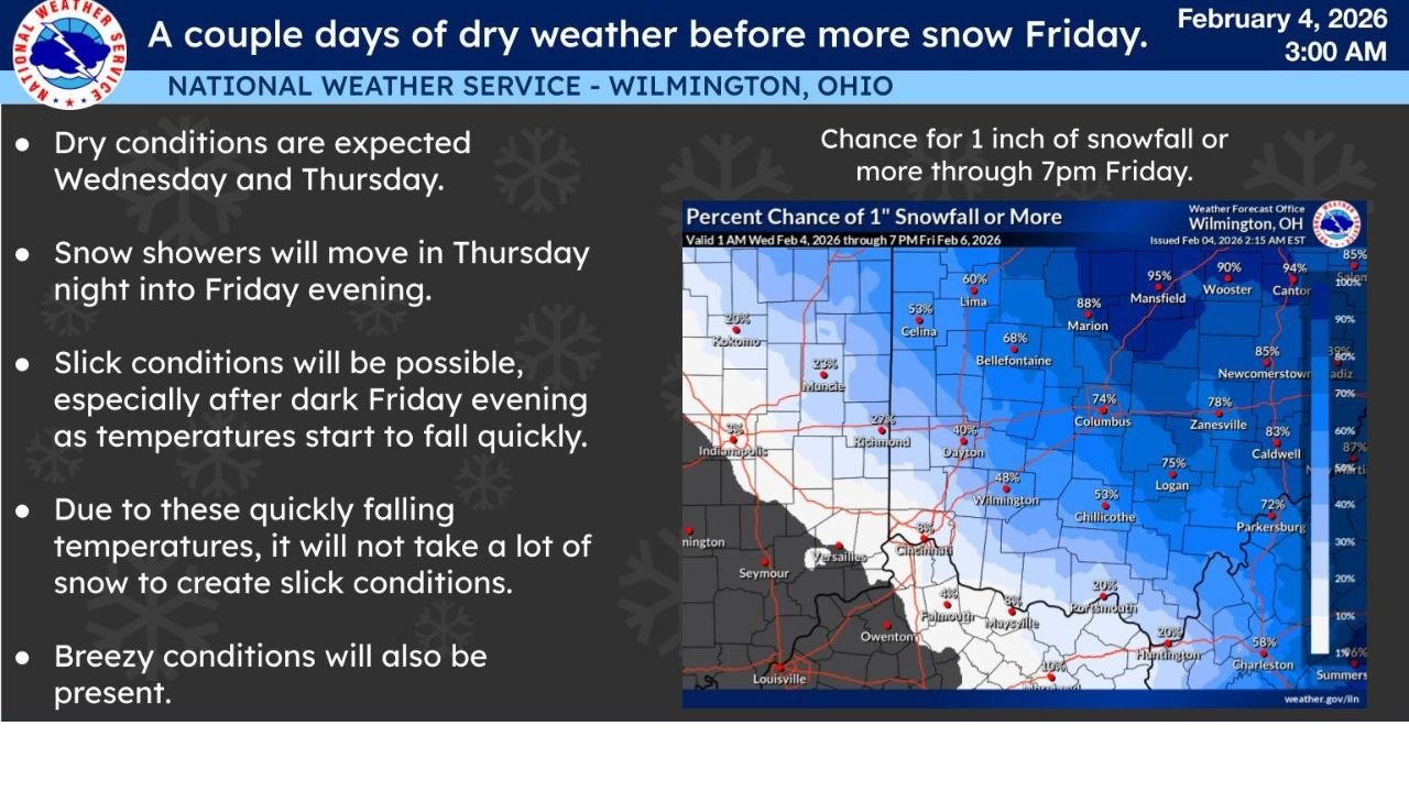
Snow Showers Arrive Thursday Night
Snow showers are forecast to begin moving into parts of Ohio, eastern Indiana, and northern Kentucky late Thursday night, continuing at times through Friday evening. While snowfall totals are not expected to be extreme, the timing of the snow could create issues for both the Friday morning and evening commute.
Forecasters emphasize that snowfall coverage may vary, but nearly all areas have at least some chance of seeing accumulating snow during this period.
Slick Roads Likely Friday Evening
One of the primary concerns highlighted by the Weather Service is the rapid temperature drop expected Friday evening. As temperatures fall quickly after sunset, any moisture on roadways — including light snow — may freeze, creating slick and hazardous travel conditions.
Officials note that it will not take much snow to cause problems, especially on untreated roads, bridges, and overpasses.
Breezy Conditions Add to Travel Concerns
In addition to snow, breezy conditions are expected to develop across the region. Gusty winds could reduce visibility at times during snow showers and contribute to colder-feeling conditions for those outdoors.
Drivers are urged to use caution, particularly during periods of falling snow and rapidly changing road conditions.
What Residents Should Expect
Residents across Ohio, eastern Indiana, and northern Kentucky should prepare for changing weather conditions late Thursday into Friday by allowing extra travel time, monitoring local forecasts, and staying alert for updates as the event approaches.
While this system is not expected to produce major snowfall totals, its timing and quick temperature drop increase the risk for slick travel and localized impacts.
Stay with WaldronNews.com for continued updates as forecasters refine snowfall timing and impacts closer to Friday.