
Cyclone Mitchell Strengthens Offshore as Uncertain Track Puts Western Australia Coast From Onslow to North West Cape on Alert
WESTERN AUSTRALIA — Cyclone Mitchell, currently equivalent to a Category 1 hurricane, is approaching the northwestern coast of Western Australia, with forecasters closely watching its unusual approach angle that is complicating landfall timing and location.
Based on the current setup, the system could make landfall anywhere between Onslow and North West Cape as early as Sunday, though confidence remains limited due to the storm’s asymmetrical structure and non-traditional track.
Unusual Track Adds Uncertainty to Landfall Forecast
Cyclone Mitchell is not approaching the coast on a typical west-to-east path. Instead, the storm is moving in at a weird, angled trajectory, making it difficult to pinpoint exactly where the core will cross the coastline.
This unusual motion increases uncertainty for communities along the Pilbara coast, particularly between:
- Onslow
- Karratha
- Port Hedland
- North West Cape
- Nearby inland locations including Pannawonica and Tom Price
Small shifts in direction could significantly alter which areas experience the strongest impacts.
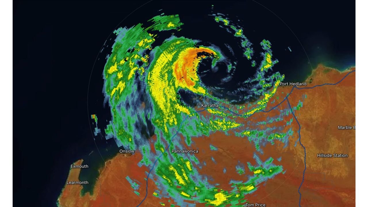
Radar Imagery Shows Lopsided but Intensifying Structure
Radar data shows Cyclone Mitchell with a lopsided appearance, featuring stronger bands and heavier precipitation concentrated on one side of the circulation rather than evenly wrapped around the center.
Despite this asymmetry, the system is expected to strengthen, with expanding rain bands already impacting coastal and inland portions of northwestern Western Australia.
Heavier precipitation bands are evident near and west of Karratha, while additional rain and squalls extend southward toward Onslow and inland toward Tom Price.
Primary Threats: Heavy Rain, Squalls, and Coastal Impacts
While exact impacts remain uncertain, the system’s current structure supports concerns for:
- Heavy rainfall, particularly near and south of the core
- Gusty winds, strongest closer to the center and in heavier bands
- Rapidly changing conditions along the coast as the storm approaches
Communities along the Pilbara coastline are advised to remain alert as conditions could deteriorate quickly once the storm begins interacting with land.
What to Watch Going Forward
Forecasters will be closely monitoring:
- Whether Cyclone Mitchell continues strengthening before landfall
- Any shift north or south in its track
- How the storm’s asymmetric structure evolves closer to the coast
Because of the storm’s unusual motion, confidence in exact landfall location remains low, and impacts could shift with little notice.
WaldronNews.com will continue tracking Cyclone Mitchell and provide updates as clearer guidance on timing and coastal impacts becomes available.