
Major Winter Storm Taking Aim at Washington, D.C., New York City and Boston With Widespread 8–12 Inches and Potential 12–24 Inch Swath if Track Holds
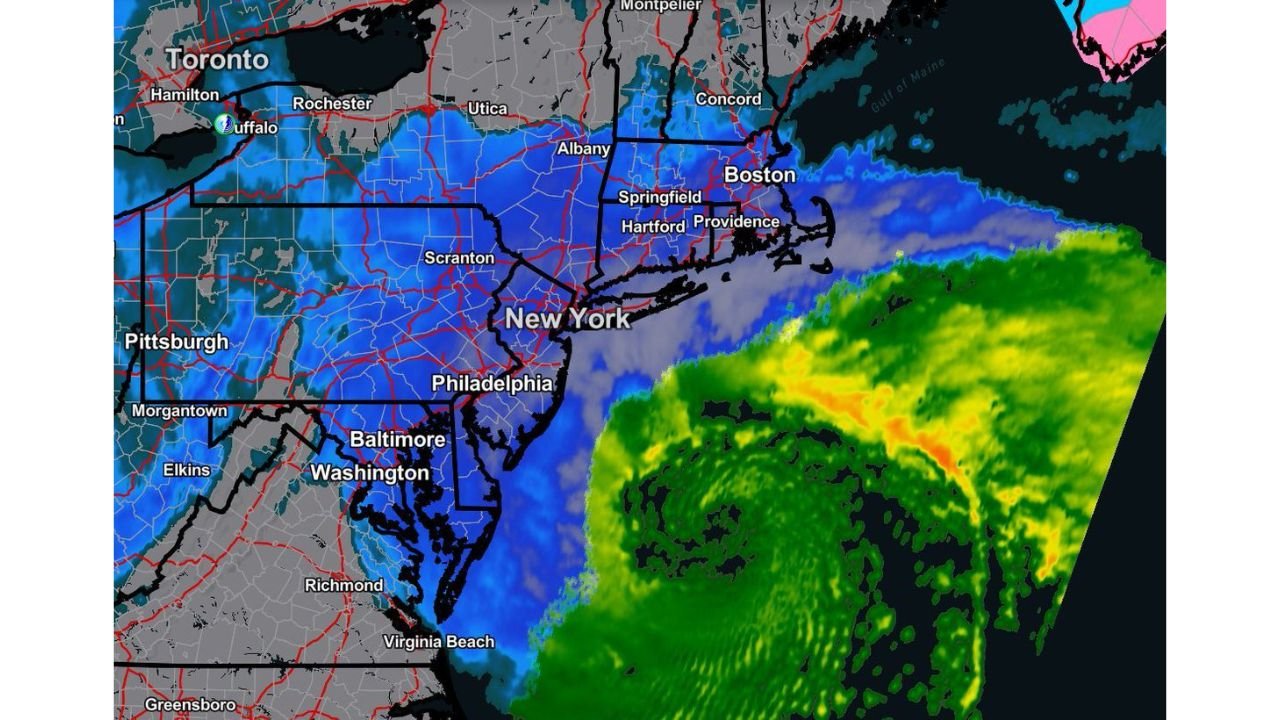
NORTHEAST UNITED STATES — Confidence is growing that a significant winter storm will impact the Northeast Sunday into Monday, bringing widespread accumulating snow from Washington, D.C. through Baltimore, Philadelphia, New York City and Boston.
Forecasters now indicate that a broad swath of 8 to 12 inches of snowfall is becoming increasingly likely if the storm track remains steady over the next 24 hours. Should the system maintain its current projected path and intensity, a more intense band of 12 to 24 inches could develop in areas that experience prolonged heavy snow banding.
Widespread Snow From D.C. to Boston
The projected impact zone includes:
- Washington, D.C.
- Baltimore
- Philadelphia
- New York City
- Hartford and Providence
- Boston and surrounding eastern Massachusetts communities
- Portions of upstate New York, including Albany
- Areas near Scranton and central Pennsylvania
Snow is expected to expand northward into interior New York and southern New England, with heavy precipitation visible offshore feeding moisture into the system.
8–12 Inches Increasingly Likely
Current guidance supports a scenario where much of the I-95 corridor receives:
- 8–12 inches of snowfall
- Locally higher amounts where snow bands stall
This level of snowfall would create widespread travel disruptions, especially late Sunday into Monday morning.
12–24 Inches Possible in Heavier Bands
If the storm continues strengthening along its projected path, mesoscale banding could produce a corridor of significantly higher totals.
That heavier axis could bring:
- 12–18 inches
- Isolated 20+ inch totals in persistent heavy snow bands
These higher totals would most likely occur from eastern Pennsylvania through northern New Jersey into portions of the New York City metro and possibly into interior southern New England.
Track Still Matters
Forecasters stress that while confidence is increasing, small shifts in track remain critical.
An eastward shift would pull the heaviest snow closer to the coast and potentially trim totals inland. A slightly more westward solution would increase snowfall totals across major metro areas.
Because of this, the next 24 hours of model updates will be key in fine-tuning the snowfall gradient.
Travel Impacts Expected
Heavy snow rates, especially during peak banding, could quickly overwhelm road treatment efforts. Sunday evening into early Monday may see the worst travel conditions.
Air travel delays are also possible at major hubs including:
- Reagan National and Dulles (D.C.)
- Baltimore/Washington International
- Philadelphia International
- Newark Liberty
- LaGuardia and JFK
- Boston Logan
Bottom Line
A major winter storm is increasingly likely across the Northeast Sunday into Monday. Widespread 8–12 inches appears probable from Washington to Boston, with the potential for 12–24 inches in areas that see prolonged heavy snow bands.
Residents across the Mid-Atlantic and Northeast should prepare for significant winter weather impacts and monitor updates as forecasters refine the storm track.
Stay with Waldronnews.com for continuing coverage as this winter storm approaches.