
Pennsylvania, New York and New England in the Snow “Rich Get Richer” Zone as Euro and GFS Paint 12–20+ Inches Next Week
UNITED STATES — Long-range guidance from both the European (ECMWF) and American (GFS) weather models is signaling a potentially significant snow setup across parts of Pennsylvania, New York, Connecticut, Rhode Island, Massachusetts, Vermont, New Hampshire, and Maine heading into early March.
The pattern suggests a classic “rich get richer” scenario — meaning areas that have already seen frequent snow this winter could once again find themselves under the heaviest totals.
While this remains several days out, model consistency between the Euro and GFS is drawing attention.
ECMWF: 12–18+ Inches Across Southern Tier and New England
The ECMWF total snowfall projection (valid through early March 4, 2026) shows a concentrated band of heavier snow stretching across:
- Central and eastern Pennsylvania
- Southern New York
- Northern New Jersey
- Interior Connecticut
- Much of Massachusetts
- Southern Vermont and New Hampshire
Within that corridor, projected totals range from:
- 10–12 inches across much of central Pennsylvania and southern New York
- 14–16 inches across portions of eastern Pennsylvania and western Massachusetts
- Localized amounts near or above 18 inches in parts of interior New England
The heaviest band appears to arc from central Pennsylvania northeastward through the Hudson Valley and into southern New England.
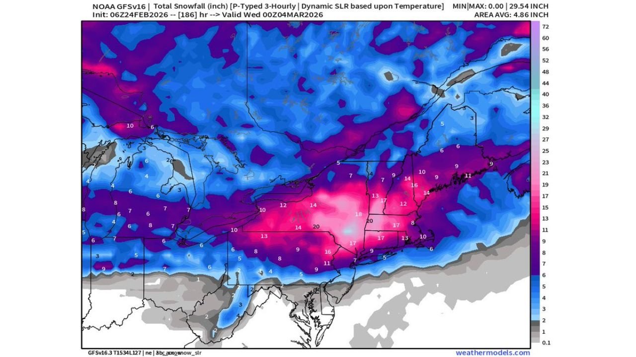
GFS: Even Higher Localized Totals
The NOAA GFS model paints a similar footprint but with even more aggressive localized maxima.
Key highlights include:
- 15–20 inches across portions of central Pennsylvania
- 12–18 inches extending into southern New York
- Widespread 10–15 inches across interior New England
- Strong signal for heavier snow in the higher terrain
In some pockets, the GFS shows isolated totals pushing near or above 20 inches, particularly in parts of Pennsylvania’s higher elevations.
I-95 Corridor: Lower but Still Significant Totals
Closer to the Interstate 95 corridor — including:
- Philadelphia, Pennsylvania
- New York City, New York
- Hartford, Connecticut
- Providence, Rhode Island
- Boston, Massachusetts
Snowfall projections are somewhat lower but still impactful, generally in the 6–12 inch range, depending on track and temperature profiles.
As always with coastal and near-coastal zones, slight shifts in storm track could dramatically change outcomes.
Western Cutoff and Lake Regions
Farther west into:
- Western Pennsylvania
- Northern Ohio
- Western New York
Totals taper somewhat but still show moderate accumulations in many areas.
Meanwhile, northern New York and parts of upstate regions could see enhanced totals depending on storm evolution and lake interactions.
Why “Rich Get Richer”?
The phrase reflects a repeating storm track pattern that favors:
- Southern Pennsylvania into New York
- Interior New England
- Elevated terrain zones
If the track remains consistent, snowpack in these regions could deepen substantially heading into early March.
Still Long Range — But Signal Is Strong
These projections extend out several days and will evolve with each model cycle. Key factors that could alter totals include:
- Exact storm track
- Temperature profiles near the coast
- Strength of cold air supply
- Timing and phasing of upper-level energy
However, when both the Euro and GFS align on a similar snow corridor this far out, it increases confidence that a notable winter event is possible.
Residents across Pennsylvania, New York, New Jersey, Connecticut, Massachusetts, Vermont, New Hampshire, and Maine should monitor forecast updates closely as next week approaches.
WaldronNews.com will continue tracking model trends and refining snowfall projections as the potential early March system develops.