
Wyoming to Colorado Cold Front Unleashes High Winds, Mountain Snow and Thunderstorms Across Nebraska and Western Kansas
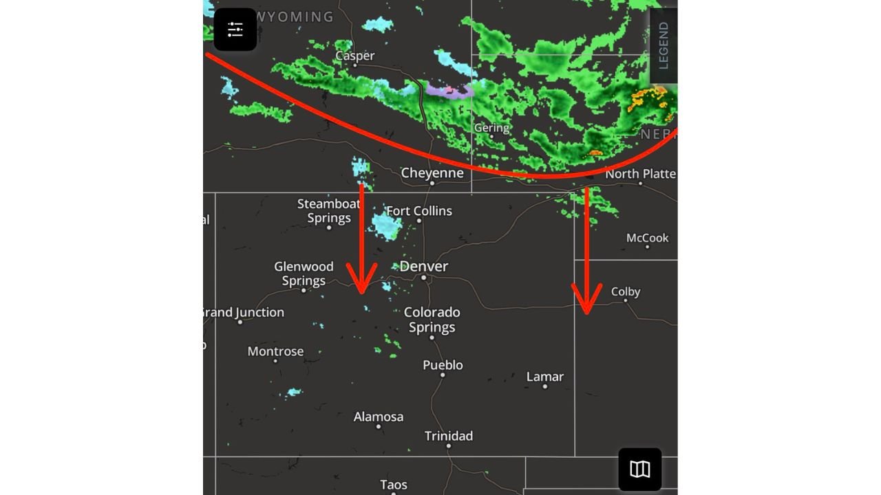
WYOMING — A powerful cold front is pushing south out of Wyoming into Nebraska and is set to surge through Colorado and western Kansas through the afternoon and evening, bringing strong winds, mountain snow and scattered thunderstorms to parts of the central Rockies and High Plains.
The frontal boundary, already slicing across southern Wyoming near Casper and Cheyenne, is diving toward northern Colorado and western Nebraska, creating sharp weather contrasts across the region.
Strong Winds Continue Along the Front Range and High Plains
The strongest winds are expected to persist through about 6 PM, especially across:
- Southeastern Wyoming
- Northern and eastern Colorado
- Western Nebraska
- Western Kansas
Gusty conditions have been especially noticeable along and east of the Continental Divide, including areas near Cheyenne, Fort Collins, Denver and Colorado Springs.
While winds may ease somewhat after sunset for lower elevations, elevated terrain and foothill communities could continue to see strong mountain wave winds into tonight and Thursday — with breezy conditions possibly lingering into Friday.
Residents across the region are advised to secure outdoor furniture and avoid unnecessary travel during peak gust periods.
Mountain Snow Returns Along and North of I-70
As the colder air settles in, snowfall is increasing across the higher elevations of Colorado, especially:
- Along and north of Interstate 70
- Near Steamboat Springs
- Northern mountain ranges west of Fort Collins
- Foothill zones west of Denver
Light to moderate snow showers are visible on radar in parts of the central Rockies. Travel over mountain passes could become slick, particularly later in the day and overnight as temperatures fall.
Scattered Rain and Thunderstorms East of the Divide
East of the Continental Divide, lower elevations are seeing scattered rain showers, with isolated thunderstorms developing along the advancing front.
Lightning activity has already been observed across:
- Western Nebraska, including near Gering
- Areas stretching east toward North Platte
- Portions of western Kansas near Colby
These storms are not expected to produce widespread heavy rainfall, but brief downpours and gusty winds are possible.
The system is not forecast to be a major rain producer, though it should modestly increase humidity levels across parts of the High Plains.
Nebraska and Kansas in the Line of Fire
As the front pushes deeper into western Nebraska and western Kansas, cities such as:
- North Platte, Nebraska
- Colby, Kansas
- McCook, Nebraska
could experience passing showers and isolated thunder through the evening hours.
Storm coverage will likely be hit-or-miss rather than widespread.
What This Means for the Region
This is a classic spring transition system for the central Rockies and High Plains:
- Strong frontal winds
- Mountain snowfall
- Scattered convection east of the Divide
- Gradual cooling behind the front
Conditions should begin stabilizing overnight in lower elevations, though mountain areas may continue to see unsettled weather.
Residents across Wyoming, Colorado, Nebraska and Kansas should remain weather aware through the evening hours.
Stay with WaldronNews.com for continued updates as this cold front progresses south and east across the region.