
Polar Vortex Split Over the Arctic Could Trigger Eastern U.S. Cold Surge by Mid-March, Including Arkansas
UNITED STATES — A major disruption is unfolding high above the Arctic, and new model guidance suggests it could translate into a sharp Eastern U.S. cold pattern by mid-March — potentially impacting Arkansas and much of the Southern Plains.
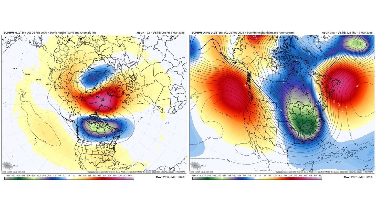
Recent ECMWF stratospheric data valid around March 6 shows a clear polar vortex split in the upper atmosphere near 50mb. Instead of one consolidated vortex spinning over the North Pole, the circulation is dividing into two lobes — a classic signal of a stratospheric disruption.
These events often precede significant pattern changes at the surface.
What the Stratospheric Maps Show
The first map highlights the 50mb height anomalies over the Arctic. Key features include:
- A strong positive anomaly (red/pink shading) pressing into the polar region
- Displacement and splitting of the main cold-core vortex
- Two distinct lobes forming — one toward Eurasia and another toward North America
When the vortex splits, it weakens the tight circular wind structure that normally locks Arctic air in place.
Historically, this can allow cold air to spill southward in the weeks that follow.
AI Model Response: Eastern U.S. Trough by March 12
The second image, based on ECMWF AIFS guidance valid around March 12, shows a dramatic response at 500mb:
- A deep trough carving into the Eastern United States
- Strong negative height anomalies stretching from the Great Lakes into the Deep South
- A ridge building over the Western U.S.
The model depicts a large-scale cold setup centered over the Midwest, Ohio Valley, and Southeast.
Arkansas sits on the western edge of that trough axis in this projection — meaning colder-than-normal conditions would be possible if this pattern verifies.
Why This Matters for Arkansas
While Waldron and western Arkansas would not be directly under the core of the trough in the current depiction, the placement suggests:
- Below-normal temperatures possible mid-March
- Reinforced cold fronts
- Potential for active storm tracks along the trough boundary
Importantly, this setup argues against an immediate and sustained spring warmup.
When a polar vortex split is underway, atmospheric blocking patterns can take hold, slowing seasonal transitions.
Timing and Uncertainty
It’s important to stress:
- Stratospheric events do not guarantee exact surface outcomes
- The March 12 map is guidance, not a final forecast
- Impacts can take 1–3 weeks to fully translate downward
However, the signal alignment is notable:
- Stratospheric disruption around March 6
- Surface trough amplification roughly 5–7 days later
- Pattern consistent with historical vortex split responses
The Big Picture
A polar vortex split is one of the most significant winter pattern disruptors in the Northern Hemisphere. When the upper-level circulation fractures:
- The jet stream often becomes more amplified
- Cold air can surge farther south than typical
- Eastern U.S. troughing becomes more likely
For Arkansas, that could mean mid-March feeling more like late February.
Bottom Line
The polar vortex is splitting over the Arctic, and early model guidance suggests the atmosphere may respond with a large Eastern U.S. trough around March 12. If that solution verifies, Arkansas and surrounding states could see a renewed push of colder air rather than a steady march into spring warmth.
WaldronNews.com will continue tracking both the stratospheric evolution and surface model trends to see whether this mid-March pattern shift becomes reality.