
Utah Snowstorm to Bring Two Rounds of Snow From Ogden to Beaver as Cold Front and Northern Flow Could Drop Up to 6 Inches in Some Areas
UTAH — A new winter system moving across Utah and parts of the Intermountain West is expected to bring two rounds of snowfall over the next 48 hours, with some communities seeing measurable accumulation beginning tonight and continuing through Friday morning.
Forecast models show the first wave of snow arriving late tonight as a cold front pushes through the state, followed by a second round Thursday night as colder air settles across the region. While snowfall totals may vary depending on how quickly colder air arrives, many areas across northern, central, and southern Utah could see light accumulations, with certain valleys and mountain communities receiving higher totals.
First Round of Snow Expected Overnight With Cold Front
Meteorologists say the initial snowfall event will begin tonight, as the approaching cold front moves through Utah. Forecast models indicate some uncertainty about how quickly colder air will move in behind the system.
If temperatures drop quickly enough, precipitation could transition fully into snow across many valleys. Even with that uncertainty, forecasters expect a dusting up to around 2 inches of snow by early Thursday morning in several areas.
Locations along the Wasatch Front and nearby valleys could see light accumulation overnight, while elevated areas and foothills may receive slightly higher totals.
Bench Areas Could See Higher Snow Totals
The forecast suggests that bench communities and higher terrain areas have the greatest chance of reaching the higher end of projected snowfall totals.
Cities including Ogden, Logan, and areas near the Wasatch Range may see slightly more accumulation compared to lower valley locations.
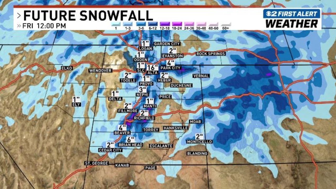
Projected snowfall amounts from the forecast model show:
- Logan: around 1 inch
- Ogden: around 1 inch
- Salt Lake City: around 1 inch
- Tooele: about 2 inches
- Park City: up to 4 inches
- Alta: up to 6 inches in higher elevations
These totals could shift depending on temperature changes and the exact track of the storm system.
Second Wave of Snow Possible Thursday Night
A second wave of snow is expected to arrive Thursday night, bringing additional snowfall to parts of the state. This round will be driven by northerly winds behind the departing system, which may continue to generate snow showers across the region.
This secondary event could bring an additional dusting up to 1 or 2 inches across parts of northern and central Utah.
Forecasters say the combination of the two snow rounds could lead to locally higher totals in some areas, especially where snow bands persist longer.
Central Utah and Mountain Areas Could See Higher Totals
Some areas in central and southern Utah may also see notable snowfall totals depending on storm development.
Projected model estimates include:
- Richfield: about 2 inches
- Fillmore: around 2 inches
- Beaver: around 4 inches
- Brian Head: up to 6 inches
- Cedar City: about 2 inches
Meanwhile, parts of eastern Utah such as Monticello could receive around 2 inches of snow by Friday.
Meteorologists say the Tooele Valley and portions of central Utah appear particularly favorable for locally higher totals due to how the system interacts with regional terrain.
Snowfall Forecast Extends Through Friday
High-resolution weather models project snowfall totals through noon Friday, meaning occasional snow showers could continue into Friday morning before the system fully exits the region.
Drivers across northern and central Utah should prepare for slick roads during overnight and early morning travel periods, especially in higher elevations and mountain passes.
Stay Updated With WaldronNews
Weather conditions can change quickly as winter systems move through the region. WaldronNews will continue monitoring snowfall forecasts, travel impacts, and weather updates across Utah and the Intermountain West.
Stay connected with WaldronNews.com for the latest weather updates, snowfall forecasts, and winter storm alerts as this system develops over the next 48 hours.