
Texas, Oklahoma, Kansas and Missouri Face Highest Severe Storm Threat Friday as Tornado, Large Hail and Damaging Winds Expand Toward Wisconsin
UNITED STATES — A widespread severe weather outbreak is expected to unfold across a large portion of the central United States on Friday, with forecasters highlighting Texas, Oklahoma, Kansas, and Missouri as the core danger zone where the most intense storms may develop. According to the latest Day 2 outlook from the Storm Prediction Center, a broad corridor of storms stretching from West Texas through the Plains and into the Midwest could bring damaging winds, large hail, and a growing tornado threat.
Meteorologists say the overall forecast idea remains largely unchanged, though recent updates have adjusted where the tornado risk is most concentrated and expanded the potential farther northeast toward Wisconsin.
Central Plains and Midwest Under Enhanced Severe Weather Risk
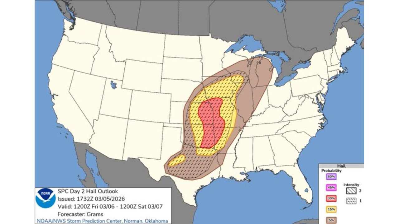
The latest outlook places a large swath of the country—from North Texas through Oklahoma, Kansas, Missouri, Iowa, and into parts of Wisconsin and Illinois—under a heightened severe weather threat.
Within this region, the Enhanced Risk zone centers over Kansas and Oklahoma, extending into portions of Missouri and northern Texas, where atmospheric conditions appear most supportive of organized severe storms.
Forecasters expect thunderstorms to develop along a dryline in the southern Plains, where warm, humid air from the Gulf of Mexico collides with drier air from the west. This boundary often acts as a trigger for explosive thunderstorm development during spring severe weather setups.
As storms form along this dryline, they are likely to track northeast through the Plains and into the Midwest, potentially organizing into clusters or lines capable of producing widespread severe weather.
Tornado Threat Expands Northeast Toward Wisconsin
One of the more notable changes in the latest forecast is the expansion of the tornado risk farther north and east.
While the highest tornado probabilities remain near the southern Plains dryline region, the Storm Prediction Center has expanded the 5 percent tornado probability zone northward into southern Wisconsin as storms evolve into a large-scale storm complex.
This means areas including Kansas City, Des Moines, Cedar Rapids, Chicago suburbs, and Milwaukee regions could experience storms capable of producing brief tornadoes embedded within lines of thunderstorms.
However, the higher-end tornado risk remains focused closer to Oklahoma and Kansas, where individual supercells may initially develop before merging into larger storm structures later in the evening.
Damaging Winds Could Become the Most Widespread Hazard
While tornadoes are possible, forecasters say damaging straight-line winds may ultimately become the most widespread impact across the region.
Storm outlook maps show a broad corridor of elevated wind probabilities stretching from Texas through Oklahoma, Kansas, Missouri, Iowa, and into the Great Lakes region.
As storms organize into lines or bowing segments, wind gusts could exceed 60 to 70 mph, capable of knocking down trees, damaging structures, and causing scattered power outages.
Communities across St. Louis, Springfield, Wichita, Oklahoma City, and Des Moines may see strong storms capable of producing intense wind bursts during the afternoon and evening hours.
Large Hail Also Possible in Strongest Storms
In addition to wind and tornado risks, the environment also supports large hail development, particularly during the early stages of storm formation in the Plains.
Forecast hail outlooks indicate a corridor of elevated hail potential extending from north Texas through central Oklahoma, Kansas, and into Missouri.
In the strongest storms, hailstones larger than one inch in diameter may occur, with isolated reports potentially reaching severe levels capable of damaging vehicles and property.
Storm System Expected to Sweep Northeast Through the Midwest
As the storm system progresses Friday evening, thunderstorms are expected to continue pushing northeast into Illinois, Wisconsin, and parts of the Great Lakes region.
This movement could bring strong storms into Chicago-area suburbs, southern Wisconsin, and parts of Michigan overnight, though the intensity of storms in these northern areas may depend on how storms evolve earlier in the day.
Meteorologists say the setup reflects a classic early spring Plains-to-Midwest severe weather pattern, where storms initiate along the southern Plains dryline before expanding northeast through the Mississippi Valley.
Residents Urged to Stay Weather Aware Friday
With multiple hazards possible—including damaging winds, tornadoes, and large hail—forecasters encourage residents across the affected region to stay alert for updated forecasts and warnings.
Key preparation steps include:
- Monitoring local weather alerts throughout the day
- Having multiple ways to receive severe weather warnings
- Identifying safe shelter locations in case tornado warnings are issued
Severe storms may begin developing by Friday afternoon in the southern Plains, with the threat shifting into the Midwest and Great Lakes during the evening and overnight hours.
Stay with WaldronNews for continuing updates as this widespread severe weather event develops across the Plains and Midwest.