
Elevated Tornado Risk Tuesday Across Texas Oklahoma Arkansas Missouri Illinois Indiana and Michigan As StormNet Highlights Developing Severe Weather Corridor
UNITED STATES — Meteorologists are monitoring a developing severe weather setup that could bring an elevated tornado risk across parts of Texas, Oklahoma, Arkansas, Missouri, Illinois, Indiana, and Michigan on Tuesday, March 10, 2026.
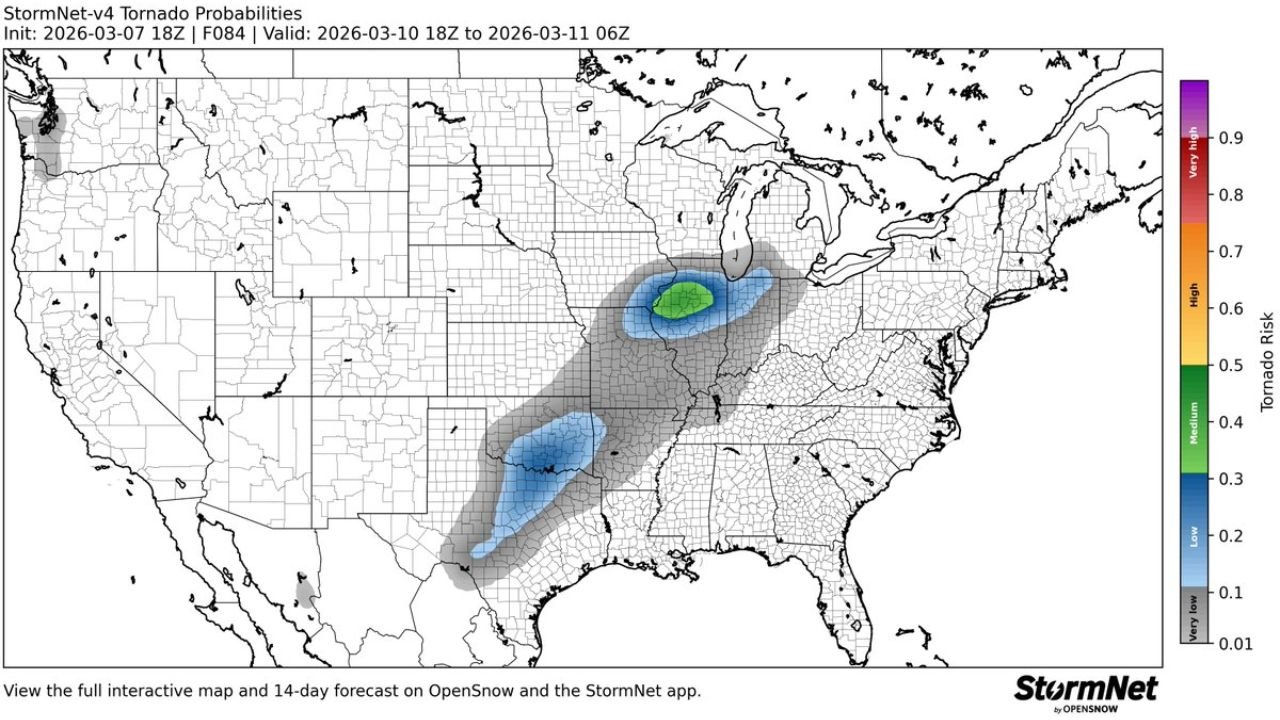
New forecast guidance from the StormNet v4 tornado probability outlook highlights a broad corridor of potential tornado activity stretching from the Southern Plains through the Mississippi Valley and into the Midwest, signaling the possibility of rotating thunderstorms capable of producing tornadoes.
The forecast window for the potential severe weather event extends from 18Z Tuesday (early afternoon) through 06Z Wednesday, covering much of the late afternoon and evening period when severe storms typically become most intense.
Tornado Risk Corridor Extends from Texas to the Great Lakes
Forecast maps indicate a tornado risk zone beginning in north and central Texas, extending northeast through Oklahoma and Arkansas, and continuing across Missouri, Illinois, Indiana, and toward southern Michigan.
Two primary zones of concern appear in the forecast:
- A Southern Plains corridor centered over Texas and Oklahoma
- A Midwest corridor stretching across Missouri, Illinois, Indiana, and southern Michigan
These areas may see atmospheric conditions supportive of rotating supercell thunderstorms capable of producing tornadoes.
Midwest Could See Stronger Tornado Probabilities
The forecast highlights the highest tornado probability zone centered across parts of Missouri, Illinois, Indiana, and southern Michigan, where atmospheric conditions could become particularly favorable for organized severe thunderstorms.
Cities and regions potentially within the higher-risk area include:
- St. Louis, Missouri
- Springfield and central Illinois
- Indianapolis and surrounding parts of Indiana
- Southern portions of Michigan
If storms develop in this corridor, they could become supercells capable of producing tornadoes, damaging winds, and large hail.
Southern Plains Also Facing Severe Storm Potential
Another area of concern appears across north and central Texas into southern Oklahoma, where thunderstorms may begin developing earlier in the day.
Storms forming in this region could move northeast into Arkansas and Missouri, potentially strengthening as they interact with more favorable atmospheric conditions farther north.
This type of storm evolution often occurs when warm Gulf moisture interacts with strong upper-level winds, creating an environment supportive of severe thunderstorms.
Early Forecast Still Subject to Change
Meteorologists emphasize that this forecast is still several days out, meaning the exact location and intensity of tornado-producing storms could shift as the event approaches.
Weather models often adjust the position of severe weather corridors as new data becomes available.
However, the presence of a broad tornado probability zone this far in advance indicates that forecasters are closely watching the developing system.
Residents Should Monitor Forecast Updates
Communities across Texas, Oklahoma, Arkansas, Missouri, Illinois, Indiana, and Michigan are encouraged to monitor weather updates as Tuesday approaches.
Severe storms can develop quickly during early spring weather patterns, and staying informed about changing forecasts can help residents prepare for potentially dangerous conditions.
Meteorologists will continue refining the outlook as new data becomes available over the coming days.
Stay with WaldronNews.com for the latest updates on the developing severe weather threat expected across the central United States Tuesday.