
Rare East West Cold Front Setup Could Trigger Severe Storms Across Kansas Missouri Illinois Indiana Ohio and Michigan Tuesday
MIDWEST — Meteorologists are closely monitoring a rare early-season severe weather setup developing across the central United States, where an unusual east-to-west oriented cold front could create conditions favorable for strong thunderstorms across parts of Kansas, Missouri, Illinois, Indiana, Ohio, and Michigan on Tuesday, March 10, 2026.
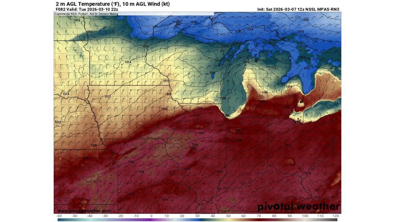
Weather model analysis suggests that a sharp boundary separating colder air across the Upper Midwest and Great Lakes from much warmer air across the central Plains and Ohio Valley could act as the focal point for storm development later in the day.
This unusual orientation of the cold front is drawing attention from forecasters because it could allow storms to develop along a long corridor stretching from the central Plains into the Midwest and Great Lakes region.
Strong Temperature Contrast Developing Across the Midwest
Weather maps show a dramatic temperature divide forming across the region.
Cooler air is forecast to remain across Minnesota, Wisconsin, and northern Michigan, while much warmer air spreads north across Kansas, Missouri, Illinois, Indiana, and Ohio.
This temperature contrast creates atmospheric instability, which is one of the key ingredients needed for severe thunderstorms.
The boundary separating these air masses appears to run roughly west to east across the Midwest, which is less common than the typical north-south oriented cold fronts that produce many severe weather events.
Storm Development Possible Along Midwest Boundary
As the day progresses Tuesday, thunderstorms may begin forming along the boundary where the warm and cool air masses meet.
Potential storm development areas could include:
- Eastern Kansas
- Missouri
- Central and southern Illinois
- Indiana
- Ohio
- Southern portions of Michigan
If storms form along this boundary, they could organize into stronger thunderstorm cells capable of producing damaging winds, large hail, and possibly isolated tornadoes.
Wind Patterns Could Support Rotating Storms
Forecast wind maps show strong low-level winds flowing northward across the Midwest ahead of the approaching system.
When winds change direction and increase with height in the atmosphere, thunderstorms can begin rotating, forming supercell thunderstorms capable of producing severe weather.
This wind pattern combined with the temperature contrast across the region could create an environment supportive of organized storms during the afternoon and evening hours.
Forecast Still Evolving
Meteorologists caution that the exact location of the cold front and the areas where storms develop may still shift as updated forecast data becomes available.
Weather models sometimes struggle with unusual setups like east-west oriented fronts, meaning the exact placement of severe weather could change over the coming days.
However, the presence of a strong temperature boundary and favorable wind conditions means the Midwest could see an active weather day if storms develop along the front.
Residents Should Monitor Forecast Updates
Communities across Kansas, Missouri, Illinois, Indiana, Ohio, and Michigan are encouraged to monitor forecast updates as Tuesday approaches.
Severe thunderstorms can develop quickly when atmospheric conditions align, especially during early spring weather patterns across the central United States.
Meteorologists will continue analyzing new data to determine whether storms will organize along the developing boundary.
Stay with WaldronNews.com for continued updates as meteorologists track the evolving severe weather threat expected across the Midwest.