
Two Strong Cold Fronts Expected to Cool Midwest and Great Lakes Including Illinois Indiana Michigan and Ohio By Mid-March
UNITED STATES — Long-range weather models are signaling a noticeable shift in temperatures across the central and eastern United States during the middle of March, as two strong cold fronts and a potential Alberta clipper system push colder air into the Midwest and Great Lakes.
Forecast data from ensemble weather models suggests that temperatures across Illinois, Indiana, Michigan, Ohio, Wisconsin, and surrounding states could trend back toward seasonal levels or slightly below normal between March 12 and March 18.
The shift comes after a stretch of warmer conditions across parts of the country, with colder air expected to surge south from Canada behind the approaching frontal systems.
Colder Air Forecast to Spread Across the Midwest and Great Lakes
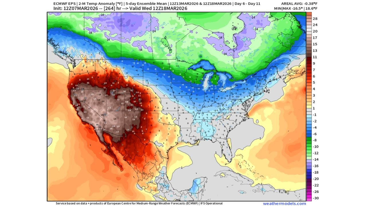
Temperature anomaly maps show below-normal temperature patterns expanding southward from Canada into the northern United States, particularly across the Upper Midwest and Great Lakes region.
Areas likely to experience cooler-than-average conditions include:
- Michigan
- Wisconsin
- Illinois
- Indiana
- Ohio
- Minnesota
- Pennsylvania
- New York
The cooler air mass is expected to push gradually southward as the frontal systems move through, bringing temperatures closer to seasonal averages after recent warmth.
Two Cold Fronts Could Reinforce the Cooling Pattern
Meteorologists are watching two separate cold fronts that could move across the central United States during this period.
The first front is expected to push cooler air into the Upper Midwest and Great Lakes, while a second reinforcing front may bring additional cold air later in the week.
In addition to the frontal passages, models hint at the possibility of a clipper-type system, which typically forms in western Canada and moves southeast across the northern United States.
These systems often bring quick bursts of colder air, gusty winds, and occasional light snow across the Midwest and Great Lakes.
Western United States Expected to Remain Warmer
While the central and eastern United States cool down, long-range models indicate that much warmer than average temperatures may develop across the western United States.
States likely to experience above-normal warmth include:
- California
- Nevada
- Arizona
- Utah
- Colorado
- New Mexico
Temperature anomaly maps show strong warm signals across the western U.S., suggesting that a ridge of high pressure could dominate the region while colder air settles across the Midwest and East.
Temperature Balance Returning Toward Seasonal Normals
Weather analysts note that the pattern shift could cause heating demand across parts of the Midwest and Northeast to return closer to normal levels, following a period of milder conditions.
The key question meteorologists are watching is how quickly warmer air may return eastward after the cold fronts move through, which could determine how long the cooler pattern remains in place.
Forecast Still Several Days Away
Because this forecast covers the Day 6 to Day 11 timeframe, the exact strength and timing of the cold air surge may still change as new model data becomes available.
However, the consistent signal across multiple forecast models suggests that a mid-March cooldown across the Midwest and Great Lakes is becoming increasingly likely.
Residents across Illinois, Indiana, Michigan, Ohio, and surrounding states should monitor forecast updates as the pattern evolves.
Stay with WaldronNews.com for the latest updates on temperature trends and changing weather patterns across the United States.