
Arkansas, Texas, Oklahoma, Missouri and Midwest States Brace for Multi-Day Severe Weather Outbreak as Tornado and Large Hail Threat Expands Through Midweek
ARKANSAS — A significant multi-day severe weather outbreak is expected to unfold across parts of the southern and central United States this week, with meteorologists warning that dangerous storms could impact several states from the ArkLaTex region to the Midwest before shifting eastward later in the week.
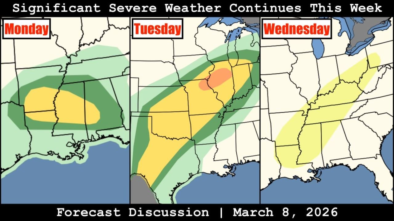
Forecast analysis issued on March 8, 2026 shows an evolving pattern capable of producing supercell thunderstorms, large hail, damaging winds, and potentially strong tornadoes from Texas and Louisiana northward through Arkansas, Oklahoma, Missouri, Illinois, and into parts of the Midwest.
The threat is expected to develop in stages beginning Monday, intensifying Tuesday, and shifting east by Wednesday.
Monday: Supercell Storms Expected Across ArkLaTex Region
The first phase of the severe weather pattern is expected Monday across the ArkLaTex region, where atmospheric conditions will support the development of strong thunderstorms.
Areas at risk include portions of:
- Eastern Texas
- Southern Arkansas
- Northern Louisiana
- Western Mississippi
- Parts of southeastern Oklahoma
Forecast models indicate that supercell thunderstorms may develop, capable of producing large hail and damaging wind gusts. While the tornado threat Monday appears more limited compared with later periods, rotating storms cannot be ruled out in the strongest cells.
The highlighted zone across southern Arkansas and northern Louisiana suggests a corridor where storms could organize during the afternoon and evening as instability increases.
Meteorologists say this early round of storms may help set the stage for a much larger severe weather event the following day.
Tuesday: Widespread Severe Weather Event From Texas to the Midwest
The most concerning period of the outbreak is expected Tuesday, when a large corridor of severe weather risk stretches from Texas through the lower Mississippi Valley and into the Midwest.
States potentially impacted include:
- Texas
- Oklahoma
- Arkansas
- Missouri
- Illinois
- Indiana
- Kentucky
Forecast guidance suggests a widespread severe weather event, with all hazards possible.
Meteorologists warn that storms Tuesday could produce:
- Strong tornadoes
- Very large hail
- Damaging straight-line winds
- Rapidly intensifying supercell thunderstorms
The highest risk area currently appears centered across Missouri and Illinois, where atmospheric ingredients such as strong wind shear, warm Gulf moisture, and an advancing storm system may combine to create favorable conditions for intense storms.
Storms are expected to begin forming in the southern Plains before expanding northeastward into the Midwest during the afternoon and evening hours.
Wednesday: Severe Weather Threat Shifts Toward the Southeast and Appalachians
By Wednesday, the storm system will move eastward, bringing another round of severe weather potential to parts of the Southeast and Appalachian region.
States in the risk corridor include:
- Mississippi
- Alabama
- Tennessee
- Kentucky
- West Virginia
- Pennsylvania
While the overall threat may be somewhat less intense than Tuesday’s peak period, thunderstorms could still produce damaging winds, isolated tornadoes, and heavy rainfall.
The risk zone stretches from the central Gulf Coast northward through the Tennessee Valley and into parts of the Mid-Atlantic region, highlighting the broad reach of this multi-day storm system.
Large Portion of the U.S. Facing Active Severe Weather Pattern
The overall setup represents a broad and dynamic severe weather pattern spanning several regions of the United States over multiple days.
Meteorologists emphasize that the combination of:
- Strong upper-level energy
- Warm, moisture-rich air from the Gulf of Mexico
- Powerful wind shear
will create favorable conditions for organized thunderstorms capable of producing dangerous weather.
Because the storm system will evolve over several days, communities across multiple states should remain alert for updated forecasts and possible severe weather alerts.
Preparedness Important as Storm Pattern Evolves
Residents in the affected regions are encouraged to monitor weather updates, review severe weather safety plans, and ensure they have multiple ways to receive warnings, especially during the peak risk periods.
Severe weather outbreaks that include supercells and tornado potential can develop rapidly, and forecasters note that conditions may change quickly as the storm system moves across the country.
Authorities stress that staying informed and prepared will be critical as this multi-day severe weather threat unfolds across the ArkLaTex region, Midwest, and parts of the eastern United States through midweek.
Stay with WaldronNews for continuing updates as meteorologists track this developing severe weather outbreak across the United States.