
Texas, Oklahoma, Arkansas, Missouri, Illinois and Indiana Face Dangerous Supercell Storm Threat Tuesday as Tornado Risk Targets Lower Midwest
UNITED STATES — A broad swath of the central and eastern United States is expected to experience widespread showers and thunderstorms Tuesday, but meteorologists are increasingly focusing on a potentially dangerous zone for supercell development across parts of the lower Midwest, including Missouri, Illinois, and Indiana.
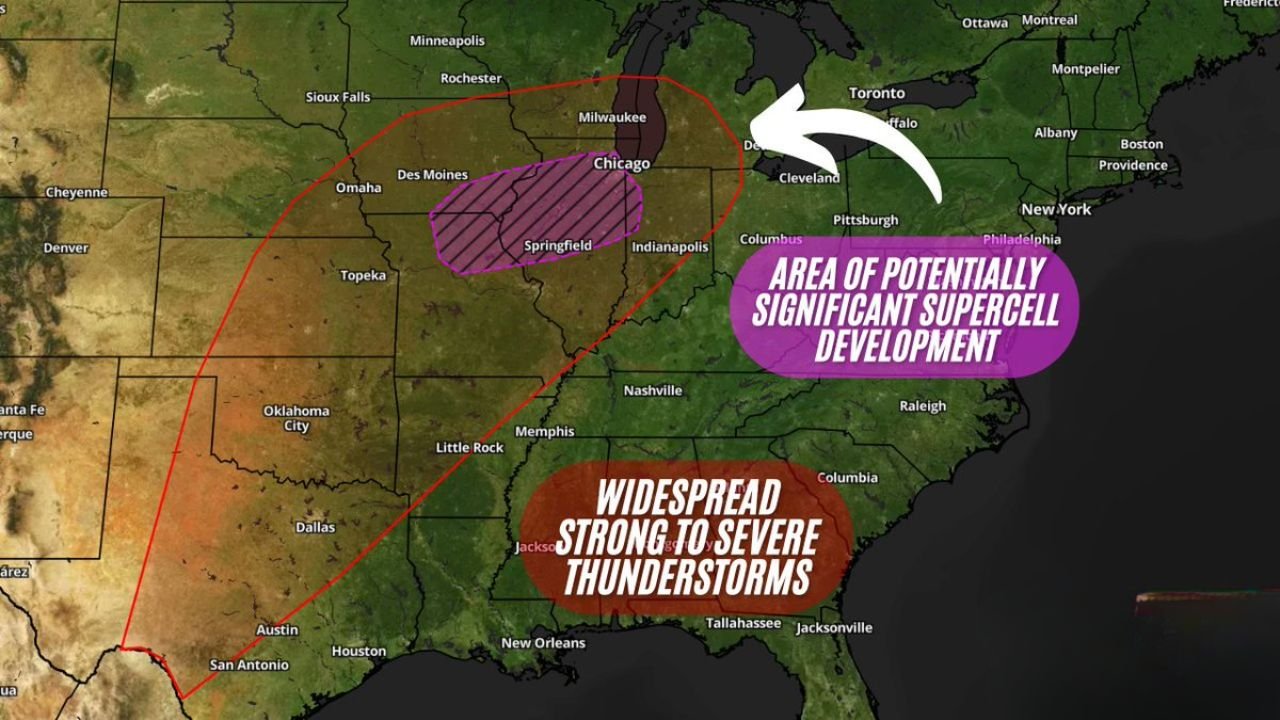
Forecast guidance indicates that while storms will be widespread across the South and Midwest, the greatest concern centers on an area where discrete supercell thunderstorms could form, raising the risk of severe weather including tornadoes, damaging winds, and large hail.
Widespread Storms Expected From Texas to the Southeast
Storm activity Tuesday is expected to extend across a large region stretching from Texas and Oklahoma eastward through Arkansas, Mississippi, Alabama, and Georgia.
Cities and regions across this corridor may see strong to severe thunderstorms, with heavy rain, lightning, and gusty winds possible.
Areas within the broader storm zone include:
- San Antonio, Austin, Dallas and other parts of Texas
- Oklahoma City and central Oklahoma
- Little Rock, Arkansas
- Memphis, Tennessee
- Jackson, Mississippi
- Birmingham, Alabama
- Columbia, South Carolina
- Tallahassee and northern Florida
While severe weather may occur throughout this region, many areas will primarily experience clusters of thunderstorms rather than isolated supercells.
Lower Midwest Identified as Potential Supercell Development Zone
Meteorologists are increasingly highlighting a more focused area for potentially significant supercell development across the lower Midwest, particularly across:
- Central and southern Missouri
- Central and southern Illinois
- Western Indiana
This zone includes communities near:
- Springfield, Illinois
- Chicago region
- Milwaukee, Wisconsin
- Des Moines, Iowa
- Indianapolis, Indiana
Forecast analysis suggests that atmospheric conditions in this region may favor isolated rotating thunderstorms, which can produce the most dangerous severe weather hazards.
Tornado Threat Possible With Discrete Supercells
If supercells develop within the highlighted zone, they could produce all types of severe weather, including:
- Tornadoes
- Large hail
- Damaging straight-line winds
Because storms may form as discrete supercells rather than a continuous storm line, the risk of tornado development could increase in areas where rotating updrafts become established.
Meteorologists often monitor these types of setups closely, as isolated supercells can produce the strongest tornadoes during severe weather outbreaks.
Storms Expected to Track Northeast Through the Midwest
Once storms develop, they are expected to move northeast across the Midwest, potentially affecting cities from Missouri and Illinois toward Indiana and parts of the Great Lakes region.
The storm track suggests that areas including Chicago, Milwaukee, and Indianapolis could see storms later in the day depending on how quickly supercells organize.
Residents Urged to Review Severe Weather Plans
Forecasters are urging residents across the highlighted regions to monitor local weather forecasts and prepare for the possibility of severe weather Tuesday.
Officials recommend that families:
- Review tornado safety plans
- Identify safe shelter locations
- Ensure they have multiple ways to receive weather alerts
Severe storms can intensify rapidly, particularly when supercells form in environments favorable for rotation.
Forecast Continues to Evolve
Meteorologists caution that the forecast remains evolving as atmospheric conditions become clearer closer to the event, meaning the exact placement of the highest risk areas could shift.
However, the current outlook indicates that Texas, Oklahoma, Arkansas, Missouri, Illinois, and Indiana should remain alert as a large storm system moves through the region Tuesday.
Stay with WaldronNews for continued updates as meteorologists monitor the developing severe weather threat across the central United States.