
Illinois, Missouri, Indiana and Kentucky Could Face Evening Tornado Risk Tuesday as Warm Unstable Air Surges Toward Chicago, Springfield and Indianapolis
ILLINOIS — Meteorologists are closely monitoring a developing severe weather setup across the Midwest as warmer and increasingly unstable air spreads north into Illinois, Missouri, Indiana, and Kentucky Tuesday, potentially setting the stage for tornadic thunderstorms later in the evening.
Recent forecast model updates suggest the warm sector across the central United States may become significantly warmer and more unstable than earlier projections, which could delay thunderstorm development until after sunset but still create an environment capable of supporting dangerous rotating storms.
Forecasters say the evolving setup could produce discrete supercell thunderstorms capable of generating tornadoes, large hail, and damaging winds, particularly across parts of central Illinois, eastern Missouri, western Indiana, and northern Kentucky.
Warm and Moist Air Spreading Across Midwest States
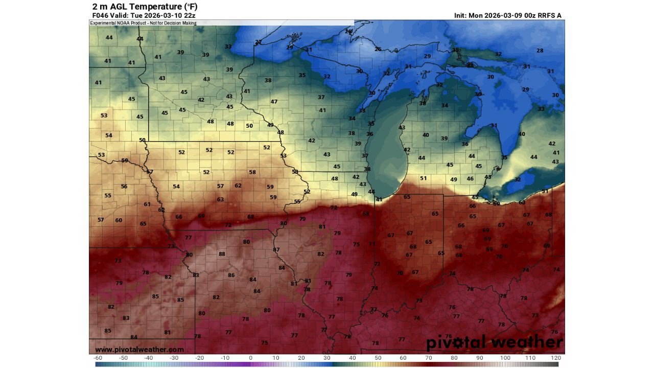
Temperature projections show a strong surge of warm air pushing northward across the Midwest Tuesday afternoon.
Forecast temperatures indicate:
- Upper 70s to low 80s across Missouri
- Mid to upper 70s across Illinois
- Mid 70s across Indiana and Kentucky
- Cooler conditions remaining farther north across Wisconsin and Michigan
This sharp temperature contrast helps define the warm sector of the storm system, where the most unstable atmospheric conditions are expected to develop.
Cities expected to experience these warmer conditions include:
- St. Louis, Missouri
- Springfield, Illinois
- Peoria, Illinois
- Chicago metropolitan region
- Indianapolis, Indiana
- Louisville, Kentucky
The influx of warm and humid air from the south will provide fuel for thunderstorms once storms begin to develop.
Storm Development May Be Delayed Until Evening
One notable element of the forecast is that storm initiation may not occur until after sunset, according to some model simulations.
Warmer surface temperatures may temporarily suppress early storm development, preventing thunderstorms from forming until the atmosphere becomes more favorable later in the evening.
Meteorologists note that if the sun remains out for much of the day, temperatures could become quite warm across the warm sector, which may delay storm formation until later.
However, once storms do begin developing, they could quickly intensify.
Conditions Could Support Tornadic Supercells
Despite the delayed storm development, forecasters say the overall environment may still support supercell thunderstorms capable of producing tornadoes.
Key atmospheric ingredients expected to be present include:
- High atmospheric instability
- Strong wind shear across the region
- Moisture-rich air flowing northward from the Gulf of Mexico
These ingredients can help thunderstorms develop rotating updrafts, which are necessary for tornado formation.
Meteorologists caution that if storms remain isolated rather than forming a large line, the tornado risk could increase.
Surrounding Midwest States Also Monitoring Severe Storm Risk
While Illinois appears to be near the center of the warm sector, nearby states including Missouri, Indiana, and Kentucky may also experience strong storms Tuesday evening.
Storms developing across eastern Missouri and Illinois could track northeast toward Indiana and southern Michigan later in the night.
Communities in the following areas may need to monitor weather conditions closely:
- St. Louis, Missouri
- Springfield and Peoria, Illinois
- Chicago suburbs
- Indianapolis, Indiana
- Louisville, Kentucky
Forecast Still Evolving as Meteorologists Monitor Conditions
Meteorologists stress that the severe weather forecast remains highly dependent on how quickly storms develop Tuesday afternoon and evening.
If thunderstorms form earlier in the day, the severe threat could begin sooner. If storms hold off until evening, the tornado risk may shift into nighttime hours, which can make severe weather more dangerous.
Residents across Illinois, Missouri, Indiana, and Kentucky are encouraged to remain weather-aware and monitor forecasts closely.
Stay with WaldronNews for continued updates as meteorologists track the evolving severe weather and tornado threat across the Midwest.