
Gulf Marine Heat Wave Surges 10°F Above Normal, Potentially Supercharging Severe Storms Across the Plains and Midwest
GULF OF MEXICO — A significant marine heat wave has taken hold across the Gulf of Mexico, with sea surface temperatures running as much as 10 degrees Fahrenheit above average in some immediate coastal waters.
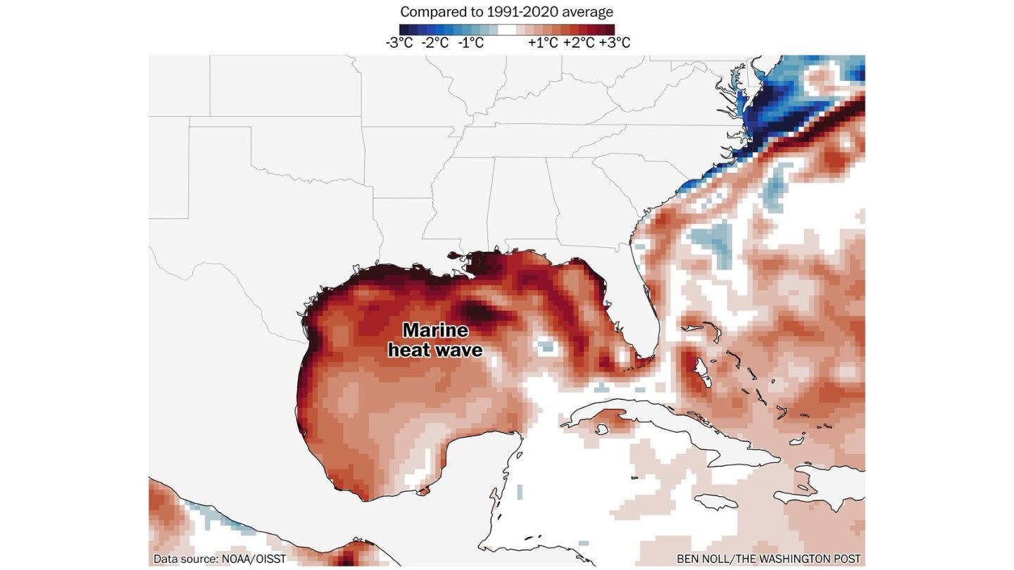
New sea surface temperature anomaly data compared to the 1991–2020 average shows a broad and intense zone of unusually warm water stretching from the Texas coastline across Louisiana and into parts of the northern Gulf near Mississippi and Alabama.
The deepest red shading on the map highlights the most extreme departures from normal, signaling water temperatures that are several degrees Celsius above climatology — a remarkable anomaly for early March.
Where the Warmest Waters Are Located
The strongest marine heat signatures appear concentrated:
- Off the Texas coast
- Along coastal Louisiana
- In portions of the north-central Gulf
While the Atlantic coast off the Southeast shows mixed signals, including some cooler-than-average waters near parts of the Mid-Atlantic, the Gulf stands out as a dominant warm pool.
The anomaly zone is especially pronounced in nearshore waters, which are critical for transferring heat and moisture into the lower atmosphere.
Why This Matters for Severe Weather
Unusually warm Gulf waters act as a powerful moisture source for storm systems tracking into the southern Plains and Midwest.
When low-pressure systems develop over Texas or the Lower Mississippi Valley, southerly winds pull Gulf moisture northward. If those waters are significantly warmer than normal, the atmosphere can load with additional humidity and instability.
That extra fuel may enhance:
- Thunderstorm intensity
- Rainfall rates
- Severe storm potential
- Tornado dynamics in favorable setups
While the marine heat wave itself does not directly create tornadoes, it can increase the available energy storms tap into as they move inland.
Timing and Broader Impacts
With severe weather season ramping up across the Plains and Midwest, this marine heat wave could play a role in upcoming storm systems, particularly those drawing deep moisture northward from the Gulf.
Early spring systems are often highly sensitive to moisture return. A warmer-than-normal Gulf can accelerate that process, leading to faster destabilization during warm-sector setups.
In addition to severe storms, prolonged Gulf warmth may also contribute to:
- Above-average humidity across the Deep South
- Increased heavy rainfall potential
- A more active early-season convective pattern
A Sign of a Volatile Pattern
Marine heat waves are becoming more closely monitored due to their role in influencing regional and national weather patterns.
In this case, the Gulf of Mexico is acting as a reservoir of elevated ocean heat just as peak severe weather season begins to unfold across the central United States.
For residents in tornado-prone areas of the Plains and Midwest, the combination of strong spring systems and an unusually warm Gulf bears watching in the weeks ahead.
Stay with WaldronNews.com for continued coverage as meteorologists track how this marine heat wave may influence the evolving severe weather pattern across the country.