
Illinois Tornado Event: Kankakee, Peotone, and Grant Park Supercell Rapidly Intensifies Into Violent EF3 Tornado
KANKAKEE, ILLINOIS — Meteorologists analyzing radar data from northern Illinois say a rapidly evolving supercell thunderstorm near Kankakee produced a powerful EF3 tornado, triggered by a sudden shift in atmospheric conditions along a warm front.
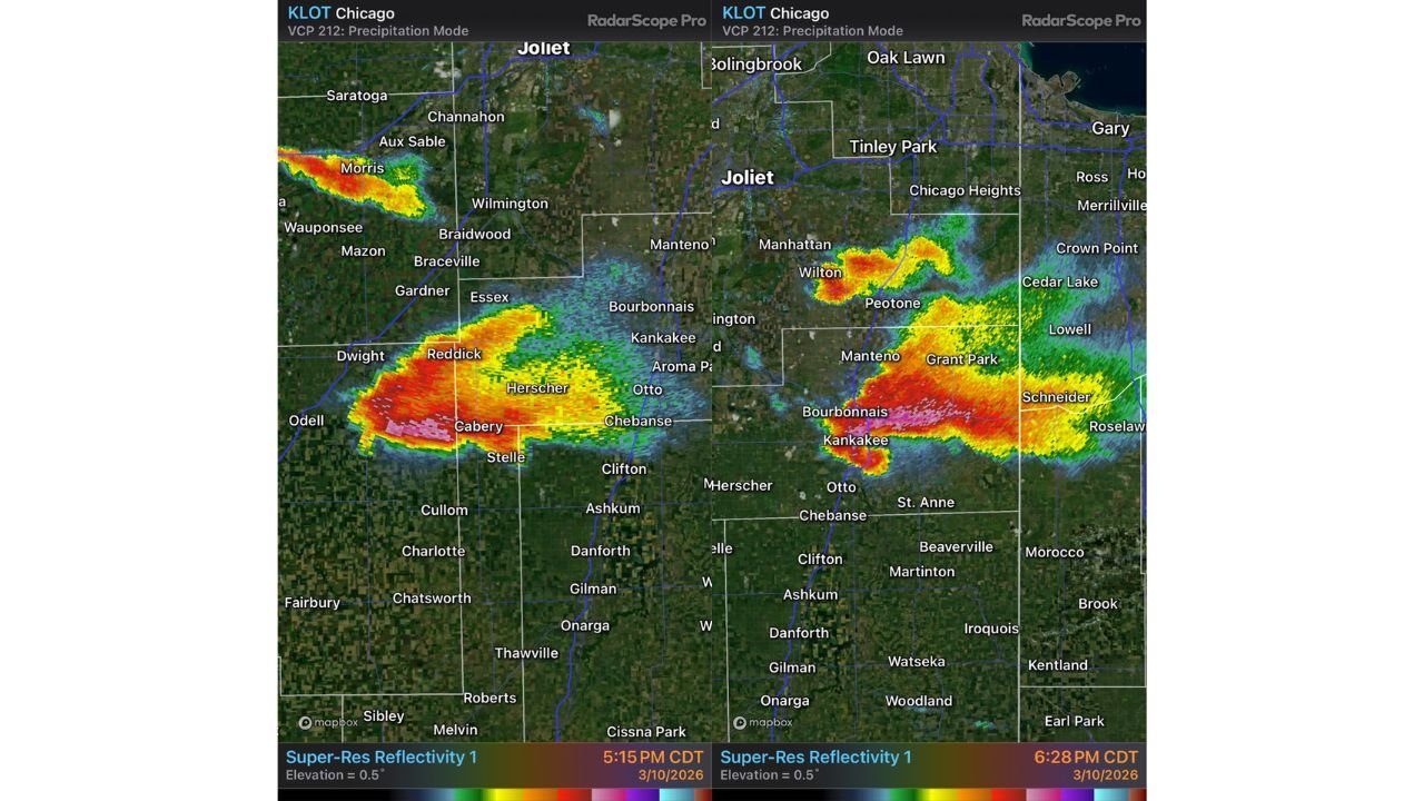
Radar imagery from the Chicago National Weather Service radar site (KLOT) shows the storm strengthening quickly as it moved across Cabery, Herscher, and Reddick before tracking toward Kankakee and Grant Park during the evening hours of March 10.
The storm displayed classic supercell structure as it moved northeast through parts of Kankakee County and southern Will County, producing intense radar signatures associated with severe rotation.
Supercell Formed in Highly Unstable Air South of Warm Front
Meteorologists say the storm initially developed within a region of strong low-level instability, south of the warm front where atmospheric energy was high.
In this early stage, the environment featured:
- Strong thermodynamic instability
- Weak low-level wind shear
- Rapid vertical storm growth
Because of the strong instability, the supercell was able to intensify quickly and produce a tornado early in its lifecycle as thermodynamic stretching enhanced the storm’s rotation near the surface.
Storm Temporarily Weakened in Less Favorable Environment
As the storm continued northeast across rural areas between Herscher and Bourbonnais, it moved into a region with lower CAPE and higher convective inhibition.
This change in atmospheric conditions briefly reduced the storm’s ability to strengthen near the ground.
Meteorologists say this phase produced a higher cloud base appearance, sometimes described by forecasters as a “cold-looking” structure, where rotation is present but not strong enough to maintain a powerful tornado.
However, the storm’s evolution was far from over.
Warm Front Interaction Dramatically Increased Tornado Potential
The key turning point occurred as the supercell approached the warm front near Kankakee County, where surface winds shifted and became backed toward the east-southeast (ESE).
This wind shift dramatically increased low-level wind shear, creating the ideal conditions for tornadic development.
When storms interact with boundaries such as warm fronts, several atmospheric changes can occur:
- Surface winds turn more easterly
- Low-level rotation increases
- Storm-relative wind speeds increase
- Updraft rotation strengthens
These changes significantly increase the likelihood of strong tornado formation.
Storm Slowed and Turned Right as Rotation Intensified
Radar images show the supercell beginning to slow down and shift its direction slightly to the right, a common behavior for tornadic supercells.
This motion change occurs when increasing wind shear strengthens the storm’s internal rotation, allowing the updraft to reorganize into a stronger low-level mesocyclone.
Communities impacted during this phase included:
- Peotone, Illinois
- Wilton Center
- Grant Park
- Southern suburbs of Chicago
The radar reflectivity signatures during this time displayed intense precipitation cores and tight rotation near the storm’s southern flank.
EF3 Tornado Developed Near Kankakee
Meteorologists say the strengthened mesocyclone eventually produced a violent EF3 tornado near Kankakee, driven by the enhanced wind shear along the warm front.
EF3 tornadoes typically produce winds between 136 and 165 mph, capable of causing significant structural damage, uprooting trees, and overturning vehicles.
The radar imagery captured during the event shows classic supercell features including:
- Intense precipitation core
- Hook-shaped storm structure
- Rapid storm intensification
These signatures are commonly associated with powerful tornadic storms.
Chicago-Area Radar Captured Storm’s Rapid Evolution
The storm was monitored using Super-Resolution radar reflectivity from the Chicago radar site (KLOT).
Radar scans taken around 5:15 PM and 6:28 PM CDT show the storm rapidly intensifying as it tracked across the Kankakee region toward the Illinois-Indiana border.
Storm cells were also visible north of the main storm near Wilton and Manhattan, indicating additional thunderstorm development within the broader severe weather environment.
Event Highlights the Complexity of Tornado Forecasting
Meteorologists say the Kankakee tornado event demonstrates how small atmospheric changes can dramatically influence tornado development.
Key factors that contributed to the tornado included:
- Strong instability south of the warm front
- Boundary interaction near Kankakee County
- Increasing low-level wind shear
- Storm motion changes enhancing rotation
Understanding how these ingredients combine is critical for improving severe weather forecasting and warning systems.
The event serves as another reminder of how quickly supercell thunderstorms can intensify when atmospheric boundaries and wind shear align.
Stay with WaldronNews for continued coverage of major severe weather events and meteorological analysis across Illinois and the United States.