
Iowa, Minnesota, Arkansas and Tennessee Brace for Monster Weekend Storm as Blizzard Threat and Tornado Outbreak Collide Across Central U.S.
UNITED STATES — Meteorologists are closely monitoring a powerful storm system expected to develop across the central United States this weekend, with forecast guidance suggesting a rare multi-hazard event that could bring blizzard conditions to parts of Iowa and Minnesota while severe thunderstorms and tornadoes threaten Arkansas, Tennessee, and neighboring states.
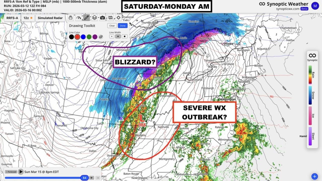
Early model simulations show a rapidly intensifying low-pressure system near the Mississippi Valley, which could drive dangerous weather across a large portion of the country from Saturday through early Monday morning.
Forecasters say the system has the potential to become a major spring storm capable of producing both winter and severe weather hazards simultaneously, depending on location relative to the storm center.
Severe Weather and Tornado Risk Focused on Arkansas, Tennessee, and Mississippi
The southern side of the storm appears most favorable for severe weather, where warm, moist air from the Gulf of Mexico is expected to surge northward.
Forecast guidance shows a corridor of intense thunderstorms stretching from:
- Arkansas
- Northern Louisiana
- Western Tennessee
- Northern Mississippi
- Southern Missouri
Cities that may fall within this potential severe weather corridor include:
- Little Rock, Arkansas
- Memphis, Tennessee
- Jonesboro, Arkansas
- Jackson, Tennessee
Meteorologists say this region could see a severe weather outbreak with multiple tornadoes possible, particularly if the storm’s warm sector becomes unstable enough to support rotating supercell thunderstorms.
The severe storm threat could intensify Saturday night into Sunday as strong winds develop in the lower atmosphere.
Strong Low Pressure System Driving the Storm
Weather maps indicate the development of a powerful low-pressure center around 988 millibars, which is considered a relatively strong storm for this time of year.
As the storm strengthens, it will pull warm air northward while drawing colder air into the northern side of the system.
This contrast between warm and cold air masses is what often fuels large and powerful storm systems across the central United States.
The strengthening pressure gradient around the storm may also produce strong winds across a wide region.
Blizzard Conditions Possible Across Iowa, Minnesota, and Wisconsin
North of the storm’s center, temperatures will be much colder, allowing precipitation to fall as snow.
Forecast projections show a wide band of heavy snow stretching across:
- Iowa
- Minnesota
- Wisconsin
- Northern Michigan
Meteorologists say this region could experience blizzard conditions, where strong winds combine with heavy snowfall to reduce visibility and create dangerous travel conditions.
The heaviest snow band may develop from central Iowa through southern Minnesota into northern Wisconsin and Michigan’s Upper Peninsula.
Strong winds circulating around the storm could produce whiteout conditions and drifting snow, especially in open rural areas.
Midwest Cities Could Experience Multiple Storm Hazards
Major cities near the transition zone between snow and severe weather may experience rapidly changing conditions.
Locations such as:
- Des Moines, Iowa
- Minneapolis, Minnesota
- Chicago, Illinois
- St. Louis, Missouri
could see a mix of rain, thunderstorms, or snow depending on the exact track of the storm.
Storm track adjustments of even a few hundred miles can dramatically shift the location of both the blizzard zone and the severe weather corridor.
Storm Expected to Intensify Through the Weekend
Forecast simulations suggest the storm will organize across the central Plains before strengthening as it moves toward the Mississippi Valley and Great Lakes.
The most intense weather impacts could occur between Saturday evening and Sunday night, with conditions gradually improving early Monday as the storm moves east.
However, meteorologists emphasize that the forecast is still evolving and details may change as newer model data becomes available.
A Large and Complex Weather Event
Large spring storm systems often bring multiple weather threats across different regions, but the scale of this storm has caught the attention of meteorologists because of the combination of hazards involved.
Communities across the central United States could face:
- Tornadoes and severe thunderstorms in the South
- Blizzard conditions in the Upper Midwest
- Strong winds across a broad region
Residents are encouraged to monitor weather forecasts closely as the weekend approaches.
Stay with WaldronNews for the latest updates as meteorologists track this powerful storm threatening Iowa, Minnesota, Arkansas, Tennessee, and much of the central United States.