
Washington’s Puget Sound Faces Snow Forecast Mystery as Weather Models Clash Over Possible Overnight Accumulation
WASHINGTON — Weather forecasters across western Washington are grappling with a major forecasting challenge as weather models strongly disagree on how much snow could fall across the Puget Sound region, creating uncertainty for communities from Seattle and Tacoma to Everett and Olympia heading into tomorrow.
Some forecast guidance suggests almost no accumulation, while other high-resolution models indicate the possibility of several inches of snowfall in localized areas, particularly away from the immediate shoreline and in slightly higher elevations.
The disagreement has made this one of the more difficult short-term forecasts meteorologists have faced this week.
Major Forecast Disagreement Between Global and High-Resolution Models
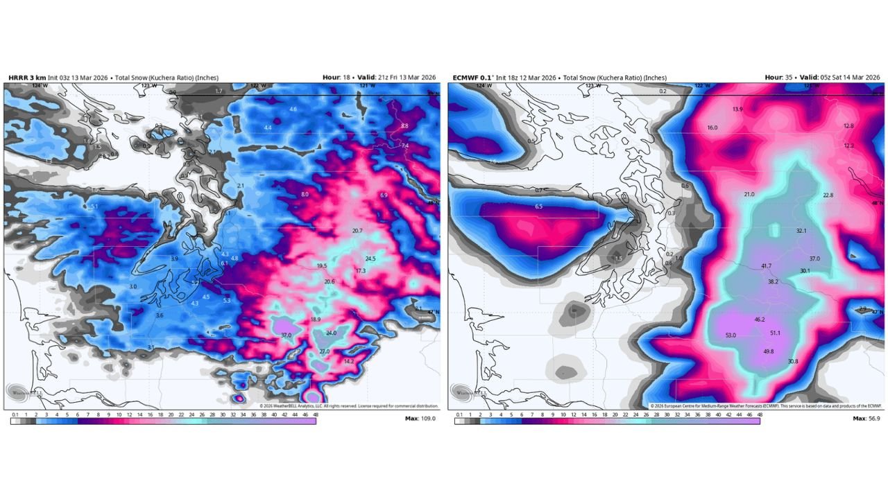
One of the primary sources of uncertainty comes from conflicting model solutions.
The European weather model, often considered one of the most reliable global models, shows only minimal snowfall totals across parts of the Puget Sound region, generally ranging from 0.0 to 0.5 inches.
In contrast, several high-resolution weather models are showing a much different scenario, with snowfall totals potentially ranging from 2 inches to as much as 12 inches in isolated areas.
These high-resolution models are designed to capture smaller-scale weather features that global models sometimes miss, which can be important in complex terrain regions like western Washington.
Puget Sound Geography Adds to Forecast Complexity
Forecasting snow in the Puget Sound area of Washington is notoriously challenging because of the region’s geography.
The presence of water, hills, and varying elevations across western Washington can dramatically affect snowfall distribution over short distances.
Locations closer to sea level along the water often remain slightly warmer, allowing precipitation to fall as rain or mixed precipitation.
Meanwhile, areas just a few hundred feet higher in elevation can quickly transition to snow.
Because of this, communities only a few miles apart may see very different outcomes.
Higher Elevations Most Likely to See Snow
Forecasters say that while many locations near the water may only see brief flurries or light snow showers, areas at slightly higher elevations may have a better chance at measurable accumulation.
Current expectations suggest:
- Coastal and low-elevation communities: Mostly rain or brief snowflakes with little to no accumulation
- Elevations a few hundred feet above sea level: A light dusting to around 1–2 inches possible
- Localized pockets farther inland: Potential for higher totals if heavier snow bands develop
The exact placement of those heavier snow bands remains uncertain.
Timing of Snow Potential
If snow does develop, it would most likely occur overnight into early tomorrow, when temperatures are coolest and precipitation intensity increases.
During overnight hours, colder air near the surface could allow snowflakes to reach the ground even in areas that remain slightly above freezing during the day.
However, small shifts in temperature or storm track could dramatically change the outcome.
Forecasters Urge Caution as Situation Develops
Meteorologists emphasize that this forecast remains highly uncertain because of the conflicting model data.
The safest expectation for now is a middle-ground scenario, where many locations see snowflakes but only limited accumulation.
Still, drivers across western Washington should remain alert, especially in areas of higher elevation where roads could briefly become slick during early morning hours.
Communities across Seattle, Tacoma, Everett, Bellevue, and Olympia are encouraged to monitor local forecasts closely as newer model data arrives.
Even a small change in storm intensity could significantly alter the snowfall forecast across the Puget Sound region of Washington.
Stay with WaldronNews for continued updates as meteorologists track the evolving snow forecast across Washington and the Puget Sound region.