
Florida, Mississippi, Jamaica and Caribbean Coastlines Highlighted in Rare Map Showing Every Category 5 Hurricane Landfall in North America
UNITED STATES — A newly compiled hurricane track map is drawing attention across the weather community by highlighting every known Category 5 hurricane landfall across North America, revealing just how rare — and destructive — these extreme storms have been throughout recorded history.
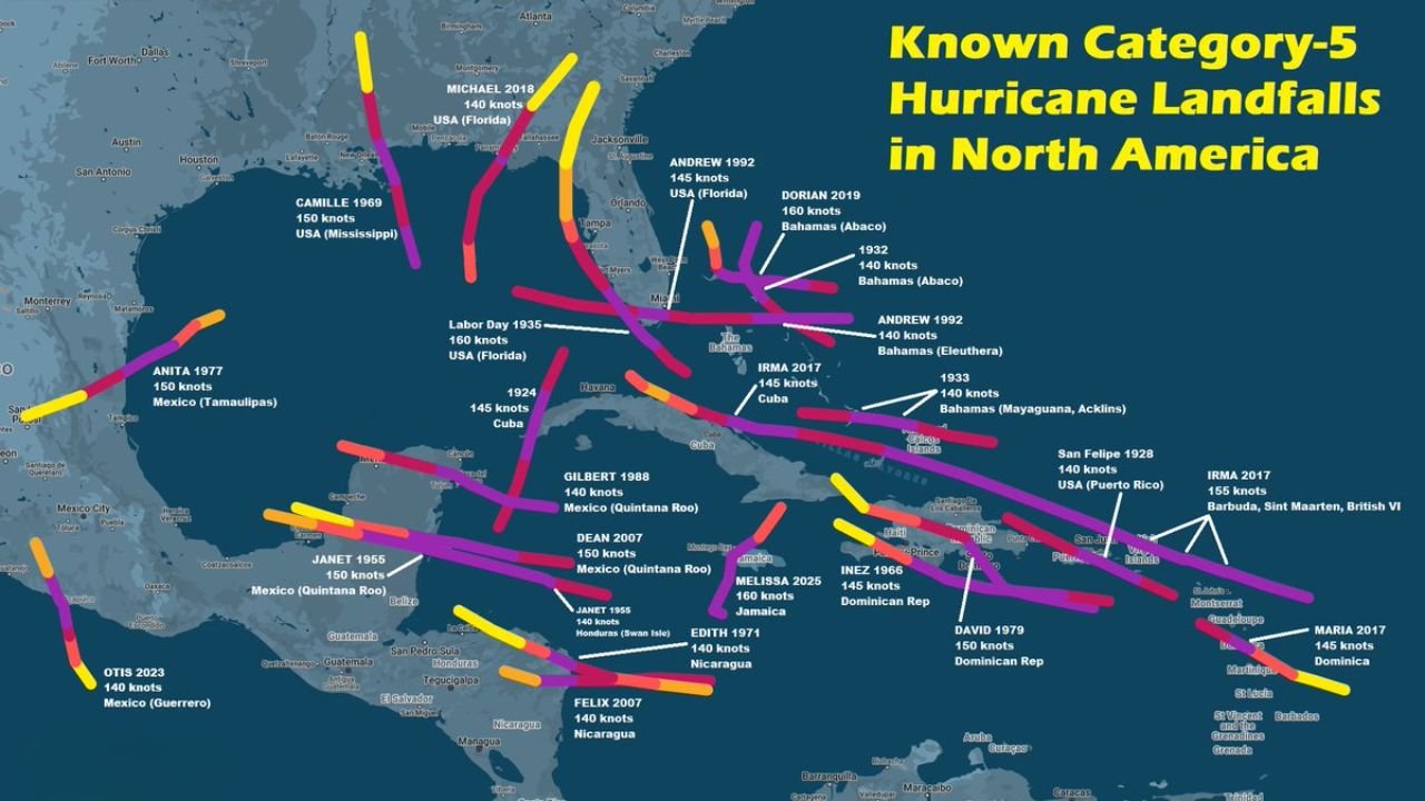
The graphic maps the tracks of storms that made landfall at Category 5 strength, meaning the hurricane’s eye crossed the coastline while still packing the most powerful classification on the Saffir–Simpson scale.
Meteorologists say the data provides a powerful reminder that Category 5 landfalls are extremely uncommon, yet when they do occur they often leave historic devastation across coastal communities.
Only a Small Number of Hurricanes Have Hit Land as Category 5 Storms
According to the compiled data, only a limited number of storms in modern records have struck land at Category 5 intensity across North America and the Caribbean.
Among the most notable examples shown on the map are:
- Labor Day Hurricane (1935) – Florida Keys
- Hurricane Camille (1969) – Mississippi Gulf Coast
- Hurricane Andrew (1992) – South Florida
- Hurricane Michael (2018) – Florida Panhandle
- Hurricane Dorian (2019) – Bahamas
- Hurricane Maria (2017) – Dominica
- Hurricane Irma (2017) – Caribbean islands
- Hurricane Gilbert (1988) – Mexico’s Yucatán Peninsula
- Hurricane Felix (2007) – Nicaragua
- Hurricane Dean (2007) – Mexico
Each of these storms reached wind speeds exceeding 157 miles per hour, the threshold required to qualify as a Category 5 hurricane.
1935, Dorian and Melissa Ranked Among the Strongest
The data also highlights an interesting historical comparison: three storms now share the distinction of the strongest Category 5 landfalls in North America.
Those storms include:
- The Labor Day Hurricane of 1935 in Florida
- Hurricane Dorian in 2019 in the Bahamas
- Hurricane Melissa in 2025 in Jamaica
Each storm reached 160 knots (about 185 mph) at landfall, placing them among the most powerful hurricanes ever recorded striking land in the Atlantic basin.
Florida and the Gulf Coast Appear Frequently in Historic Tracks
One of the most striking features of the map is how frequently Florida and the Gulf Coast appear in Category 5 hurricane history.
Florida in particular has experienced multiple catastrophic landfalls, including:
- The 1935 Labor Day Hurricane
- Hurricane Andrew in 1992
- Hurricane Michael in 2018
Meanwhile, the Mississippi Gulf Coast saw one of the most infamous storms in U.S. history when Hurricane Camille slammed ashore in 1969, producing catastrophic storm surge and extreme wind damage.
Caribbean Islands Often Face the Most Powerful Storms
The map also highlights that many of the strongest Category 5 landfalls occur in the Caribbean, where warm ocean waters and favorable atmospheric conditions allow hurricanes to reach peak intensity.
Islands including:
- Jamaica
- Dominica
- Puerto Rico
- The Bahamas
- Barbuda
- Cuba
have all experienced landfalls from some of the Atlantic basin’s strongest storms.
Because these islands sit directly in the path of tropical waves moving west across the Atlantic, they often encounter hurricanes before they weaken over land or cooler waters.
Category 5 Landfalls Remain Extremely Rare
Despite how destructive these storms can be, meteorologists emphasize that Category 5 landfalls remain very uncommon.
Many hurricanes reach Category 5 intensity over open water but weaken before making landfall due to:
- Increasing wind shear
- Interaction with land
- Cooler coastal waters
- Changes in storm structure
This makes the small number of recorded Category 5 landfalls even more notable.
Why the Map Matters for Coastal Communities
For meteorologists and emergency planners, historical maps like this help illustrate where the most extreme hurricanes have historically occurred and remind coastal communities that catastrophic storms, though rare, remain possible.
Understanding these past tracks can help guide future preparedness efforts, especially in areas where rapid intensification hurricanes could threaten heavily populated coastlines.
With hurricane seasons continuing to produce powerful storms in the Atlantic basin, experts say the history shown on the map serves as a stark reminder:
Even the rarest storms can leave lasting impacts when they strike land at full strength.
Stay with WaldronNews for continuing coverage of major weather events and hurricane history across the United States and beyond.