
Virginia, Maryland and North Carolina Face Dangerous Rotating Storm Threat Monday as Rare Atmospheric Setup Raises Tornado Concerns
UNITED STATES — Meteorologists are warning that a rare atmospheric setup could bring rotating thunderstorms and possible tornadoes across parts of Virginia, Maryland and North Carolina on Monday, March 16, as a powerful cold front moves across the Mid-Atlantic.
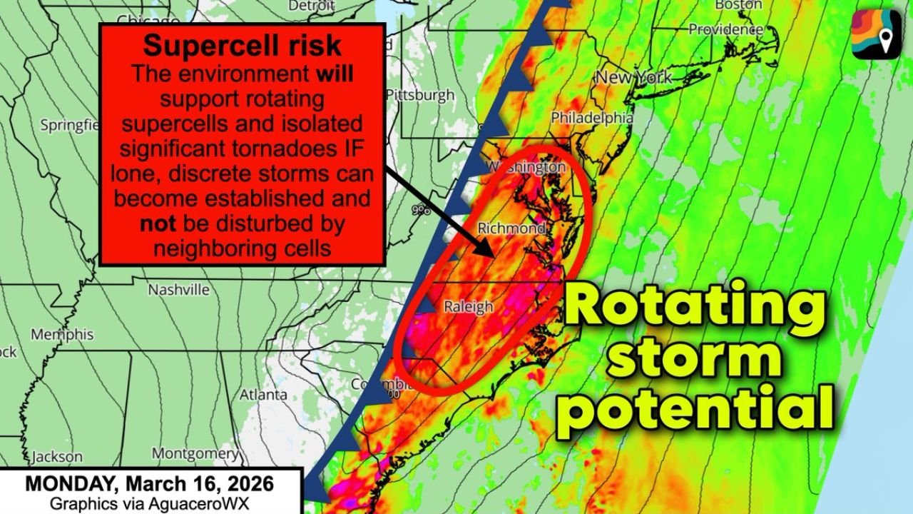
Forecast models show that the region may enter an unusual combination of atmospheric instability and strong wind shear, a pairing that forecasters say can support supercell thunderstorms capable of producing tornadoes.
Weather analysts describe the environment expected Monday as “upper-echelon parameter space,” meaning the ingredients needed for rotating storms may be unusually strong for the Mid-Atlantic region.
Rare Storm Environment Could Support Rotating Supercells
The corridor of concern stretches from central North Carolina through eastern Virginia and into Maryland, including areas around:
- Raleigh, North Carolina
- Richmond, Virginia
- Washington, DC
- Baltimore, Maryland
Meteorologists say that if storms can form ahead of the approaching cold front, isolated supercells may develop, which are the type of thunderstorms most often responsible for tornadoes.
Forecast data suggests that instability in the atmosphere combined with strong wind shear may create the right conditions for storms to begin rotating.
This kind of environment is not common along the East Coast, which is why forecasters are paying close attention to Monday’s setup.
Squall Line Expected to Bring Damaging Winds
Even if isolated storms fail to develop ahead of the front, meteorologists say a powerful squall line of thunderstorms is almost certain to form along the cold front itself.
That line of storms could sweep across the Mid-Atlantic bringing:
- Damaging wind gusts
- Heavy rain
- Possible brief tornadoes embedded within the line
Squall lines often produce widespread wind damage, especially when supported by strong jet stream winds like those expected in this system.
Cities such as Washington DC, Richmond and Raleigh could experience strong winds as the line moves through.
Biggest Uncertainty Is Storm Development Ahead of the Front
While confidence is high that severe storms will occur along the cold front, forecasters say the largest uncertainty involves whether isolated storms will form ahead of the main line.
If individual storms can develop in the warm, unstable air ahead of the front, they may have the potential to become long-lived rotating supercells capable of producing stronger tornadoes.
However, if storms remain clustered along the main line, the primary threat would likely shift toward damaging winds and brief tornado spin-ups.
Meteorologists say the situation will become clearer as newer model runs arrive closer to Monday.
Mid-Atlantic Residents Urged to Stay Weather-Aware
With the potential for severe storms moving into the region Monday, residents across North Carolina, Virginia and Maryland are being encouraged to monitor weather forecasts closely.
Safety officials recommend:
- Keeping weather alerts enabled on smartphones
- Having a safe shelter location identified
- Monitoring local forecasts Sunday night and Monday morning
Because storms could intensify quickly in this type of atmospheric environment, warnings may be issued with little notice.
Forecast updates over the next 24 to 48 hours will determine exactly how widespread the tornado threat may become across the Mid-Atlantic.
Stay with WaldronNews for the latest updates as meteorologists continue tracking this developing severe weather threat across Virginia, Maryland and North Carolina.