
Illinois, Wisconsin and Michigan Severe Weather Alert New Tuesday Storm Risk Targets Chicago Milwaukee and Grand Rapids With Tornado Threat
ILLINOIS — A new severe weather risk is emerging for Tuesday, April 14, 2026, as storm systems are expected to develop across parts of the Midwest with damaging winds, large hail, and a few tornadoes all possible.
This setup marks the first organized severe weather threat of the upcoming week, with conditions expected to intensify late Tuesday into early Wednesday.
Severe Weather Timing and Setup
Storms are expected to:
- Develop late Tuesday evening
- Continue into the early Wednesday morning hours
- Track across portions of the Midwest and Great Lakes region
The timing suggests overnight storm risks, which can be more dangerous due to reduced visibility and limited warning awareness while people are asleep.
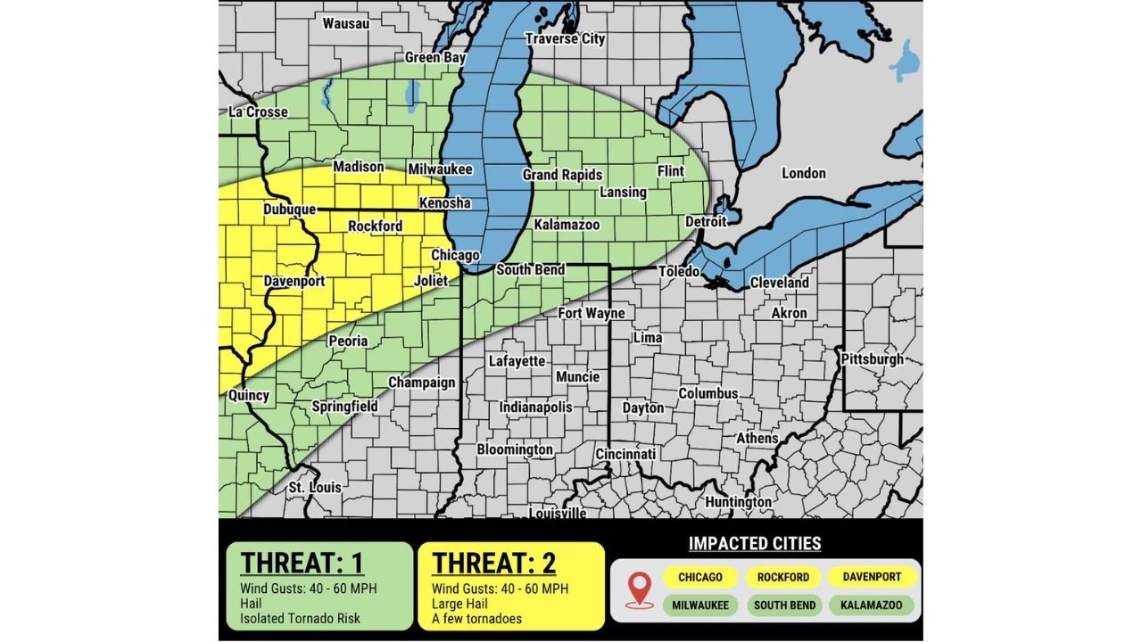
Areas Under Highest Risk
The risk zone is divided into two main threat levels:
Higher Risk Zone (Level 2 Equivalent)
This includes parts of:
- Northern Illinois
- Eastern Iowa
- Far southern Wisconsin
Key cities in this zone include:
- Chicago, Illinois
- Rockford, Illinois
- Davenport, Iowa
These areas face the greatest potential for stronger storms, including:
- Large hail
- Damaging wind gusts
- A few tornadoes
Broader Surrounding Risk Area
Extends into:
- Wisconsin
- Michigan
- Northern Indiana
Cities impacted include:
- Milwaukee, Wisconsin
- South Bend, Indiana
- Kalamazoo, Michigan
- Grand Rapids, Michigan
- Lansing, Michigan
- Detroit, Michigan
This zone still carries severe potential, but with slightly lower intensity compared to the core risk area.
Main Threats Expected
Across the region, storms may produce:
- Wind gusts between 40 to 60 mph
- Large hail capable of causing damage
- Isolated tornado risk, especially in stronger storm cells
The presence of multiple hazards means storms could quickly escalate from ordinary to severe levels.
Central Indiana Remains a Key Watch Area
While the main risk currently stays north, there is ongoing monitoring to see if storms extend into central Indiana, including areas near Indianapolis.
Any shift in storm track could expand the risk zone further southeast, making this an area to watch closely in upcoming updates.
Why This Setup Matters
This event signals a return to a more active spring weather pattern, where:
- Multiple storm systems may develop in sequence
- Severe weather threats could repeat over several days
- Conditions become more favorable for organized storms
What Residents Should Do
With severe weather possible overnight:
- Keep weather alerts enabled on your phone
- Have multiple ways to receive warnings
- Identify a safe shelter location in advance
Final Update
A developing severe weather threat for Tuesday, April 14 is expected to impact Illinois, Wisconsin, Michigan, and surrounding Midwest states, with Chicago, Milwaukee, Grand Rapids, and nearby cities in the risk zone.
Storms may bring 40–60 mph winds, large hail, and a few tornadoes, especially during the late evening and overnight hours.
Stay with WaldronNews.com for the latest updates as this system continues to evolve.