
Florida, Georgia and the East Coast Could See a Quieter 2026 Hurricane Season as Cold Atlantic Waters Suppress Storm Development
MIAMI, Florida — Good news may be on the horizon for Florida, Georgia, and the entire East Coast — the Atlantic Ocean is running significantly colder than normal across the main hurricane development zone, and that cold water is one of the most powerful brakes on hurricane formation that nature has to offer.
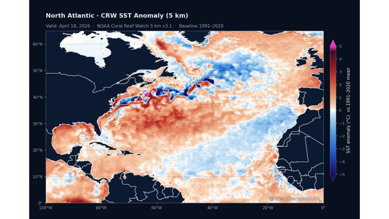
Ocean temperature maps valid through April 18, 2026 show a striking pattern: a broad cold anomaly stretching across the North Atlantic development corridor, with temperatures running 2 to 4°C below the 1991–2020 average across large portions of the basin where hurricanes typically grow and strengthen.
Regions Watching the 2026 Atlantic Hurricane Season
Every coastal state has a stake in what the Atlantic does this summer and fall:
- Florida: Miami, Tampa, Jacksonville — entire state sits in the direct path of any Atlantic or Gulf hurricane track
- Georgia: Savannah and the Georgia coast vulnerable to landfalling storms
- South Carolina and North Carolina: Charleston and Wilmington face direct hurricane threat every season
- Virginia and Maryland: Norfolk, Virginia Beach, and the Chesapeake Bay region impacted by major storms tracking up the coast
- Texas and Louisiana: Gulf Coast states always watching Atlantic and Gulf development closely
Why Cold Water Is Such Big News for Hurricane Season
The ocean temperature data tells the story in two ways:
- Standard temperature anomaly — the raw Atlantic SST map shows deep blue cold anomalies across the 40°N–50°N latitude band and extending into the main development region, running 2 to 5°C below normal in key areas
- Global-mean-removed anomaly — even after accounting for the overall warmer global ocean baseline of +0.56°C, the Atlantic still shows pronounced cold anomalies across the hurricane development corridor — meaning the Atlantic is genuinely cold relative to the rest of the world’s oceans, not just cold by historical standards
- Cold canary current — a specific cold water feature visible on both maps running along the eastern seaboard and into the central Atlantic acts as a natural suppressor of tropical storm development
- Below-average activity expected — the combination of cold SSTs and the atmospheric pattern in place points toward a below-average 2026 hurricane season for the Atlantic basin
Why This Matters for Florida and the East Coast
Miami, Florida and coastal communities from the Gulf of Mexico to Maine spend every spring bracing for what the upcoming hurricane season will bring. A season suppressed by cold Atlantic water temperatures is genuinely significant news for tens of millions of people living along the coast.
Hurricanes are heat engines. They draw their energy directly from warm ocean water — typically needing sea surface temperatures of at least 26°C (79°F) to form and sustain themselves. When the Atlantic runs cold across the main development zone, storms struggle to organize, weaken faster over cooler water, and are less likely to intensify into major hurricanes before reaching the coast.
The cold canary current showing up clearly on both the standard and global-mean-removed maps is particularly noteworthy. This cold water feature runs along a corridor that major hurricanes often track through on their way toward the US East Coast. Cold water along that path acts as a natural speed bump — sapping storm energy exactly where intensification would otherwise occur.
That said, no hurricane season is ever truly quiet for the coast that gets hit. Even a below-average season produces storms, and a single landfalling major hurricane causes catastrophic damage regardless of what the rest of the season looks like. Coastal residents should maintain their preparedness plans even as the overall outlook leans quieter.
Multi-Day Pattern
The cold Atlantic water anomalies visible now in April are meaningful because ocean temperatures change slowly — the cold pattern established now will likely persist into the June 1 hurricane season start and potentially well beyond. Unless a dramatic warm-up occurs in the Atlantic development zone over the next several weeks, this suppressive pattern could remain in place through the heart of the season in August and September.
The Pacific, by contrast, is running warmer — but it is the Atlantic that drives US hurricane risk, and right now the Atlantic is sending a cooler signal.
What to Watch Next
- Whether Atlantic SSTs warm toward normal as summer approaches or remain suppressed
- Gulf of Mexico water temperatures as the season approaches — Gulf warmth can offset Atlantic suppression for Gulf Coast states
- Early season tropical wave activity out of Africa beginning in July
- Any shift in the atmospheric pattern that could counteract the cold water suppression
- Official seasonal hurricane outlooks due in late May and early June
Florida, Georgia, and all East Coast residents should take cautious optimism from this data — but hurricane preparedness plans should be ready regardless. One storm making landfall changes everything.
WaldronNews.com will continue tracking the 2026 Atlantic hurricane season outlook and provide updates as the season approaches.