
Oklahoma, Kansas and Nebraska Face Tornadoes and Large Hail Thursday as Dryline Storms Target Wichita, Tulsa and Omaha
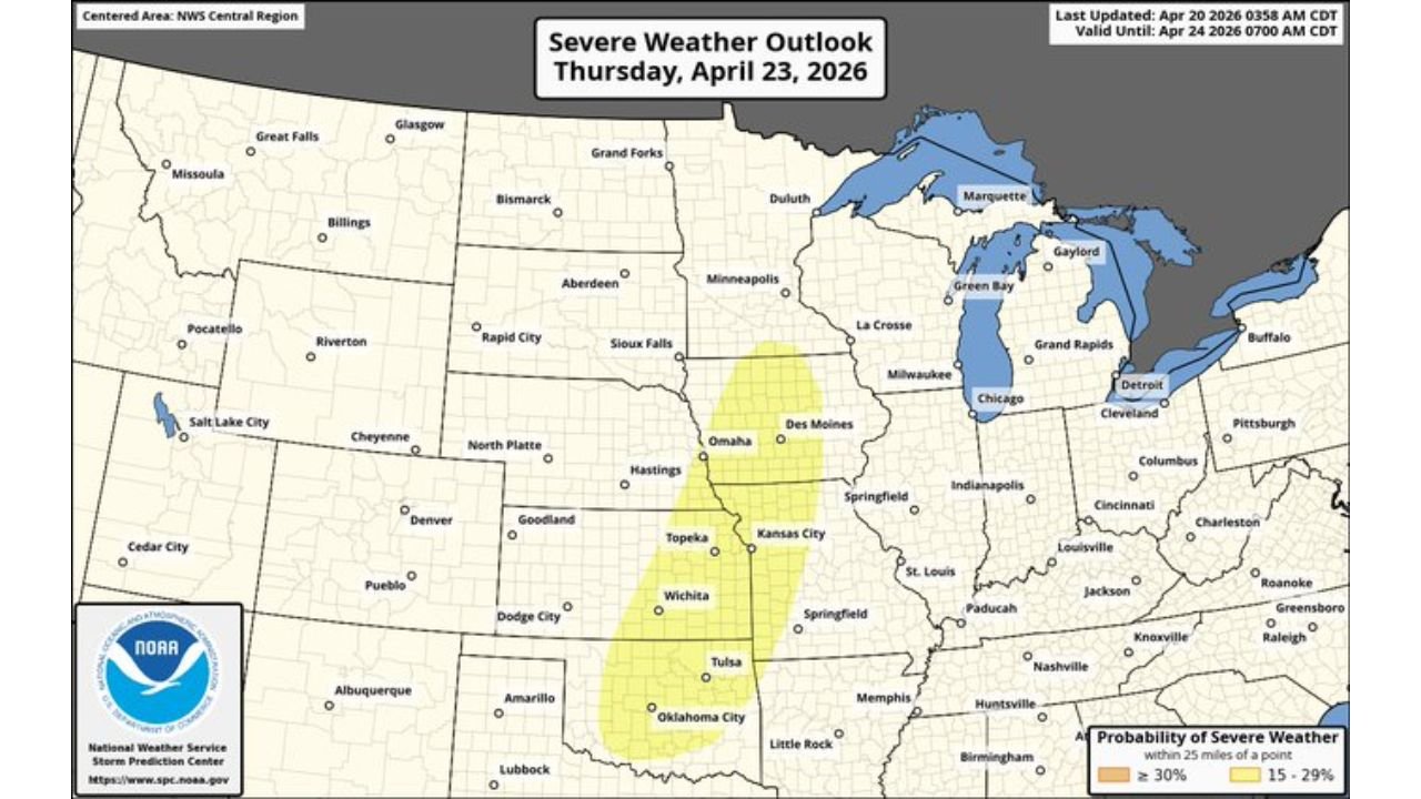
WICHITA, Kansas — A two-punch severe weather setup is developing for Thursday, April 23 across the central Plains, with Oklahoma, Kansas, and Nebraska facing threats from both a cold front and a separate dryline convection firing late Thursday afternoon into the evening. The official severe weather outlook places a 15–29% probability of severe weather within 25 miles of any point across a corridor stretching from Oklahoma City through Wichita up to Omaha.
While the main severe weather story Thursday targets the Midwest, the Plains dryline adds a second, distinct threat zone — and any storms that fire along it could be supercell capable, with tornadoes, large hail, and damaging winds all on the table.
States and Cities in Thursday’s Plains Severe Zone
The 15–29% severe probability corridor covers a significant north-south stretch:
- Nebraska: Omaha and Hastings sitting on the northern edge of the severe outlook zone
- Kansas: Wichita and Topeka directly inside the severe probability zone — one of the highest-risk cities in Thursday’s Plains setup
- Oklahoma: Tulsa and Oklahoma City on the southern end of the risk corridor with severe probability climbing
- Missouri: Kansas City on the eastern fringe of the severe threat as the dryline and cold front interact
- Iowa: Des Moines area included in the broader severe corridor as systems converge Thursday evening
Primary Threats
Thursday’s Plains setup carries multiple dangerous storm types:
- Tornadoes — if a sharp dryline develops beneath a strong mid-level wind flow, isolated supercells capable of producing tornadoes become possible across Kansas and Oklahoma Thursday afternoon
- Large hail — CAPE values and hodograph data show strong rotation potential with shear profiles supporting significant hail in any organized supercell that fires
- Damaging winds — the cold front pushing through Thursday brings wind-capable convection across the entire risk zone from Oklahoma to Nebraska
- Isolated supercells — the dryline setup specifically favors discrete, isolated storm development — the most dangerous storm mode for tornado and large hail production
Why Wichita and Tulsa Need to Watch Thursday Afternoon
Wichita, Kansas sits in a textbook severe weather geography position for exactly this type of setup. The dryline — the boundary between hot, dry air from the west and warm, moist air from the Gulf — is expected to sharpen Thursday afternoon directly over western Kansas and Oklahoma. When a dryline sharpens beneath a strong mid-level wind system, it acts like a trigger — forcing air upward and breaking the cap that has been suppressing storm development.
The atmospheric sounding data shows CAPE values of 3,000–4,500 J/kg across Kansas and Oklahoma Thursday — explosive instability that gives any storm that fires enormous energy to work with. The hodograph profiles show favorable curved wind shear consistent with supercell development. The critical angle of 104 degrees and strong low-level wind shear in the sounding data point toward an environment where supercells that do develop will have rotation from the ground up.
For Tulsa, Oklahoma and surrounding communities, the concern is the late afternoon timing. Dryline storms that fire between 4 PM and 8 PM local time have access to peak afternoon heating and can intensify rapidly. The window between storm initiation and full supercell development can be as short as 30 minutes in environments like this.
The key uncertainty is whether the dryline sharpens enough to break the cap. If it does, a few strong isolated supercells become likely. If the cap holds or the dryline remains diffuse, storm coverage could be limited. But the ingredients for dangerous storms are present — and the Plains has surprised forecasters before in setups exactly like this one.
Multi-Day Pattern
Thursday is a double-threat day — the dryline fires across the Plains in the afternoon, while the cold front simultaneously drives a larger severe weather event across Iowa, Illinois, and Wisconsin in the evening. Both threats are real and both deserve attention from residents in their respective zones.
By Friday, the system pulls northeast and conditions begin to improve across the Plains. The weekend looks quieter for Kansas and Oklahoma before the next pattern cycle begins early next week.
What to Watch Next
- Dryline sharpness and position Thursday afternoon across western Kansas and the Oklahoma Panhandle
- Cap-breaking potential — whether afternoon heating is strong enough to initiate storms along the dryline
- Tornado watch issuances for Kansas and Oklahoma Thursday afternoon
- Storm mode — discrete supercells vs. linear squall line will determine tornado vs. wind threat dominance
- Evening storm reports from the Wichita and Tulsa corridors as any dryline storms mature
Residents across Oklahoma, Kansas, and Nebraska should monitor conditions closely Thursday afternoon. The dryline setup can produce fast-developing, dangerous storms with little warning time — have your shelter plan ready before Thursday arrives.
WaldronNews.com will continue tracking Thursday’s dual severe weather threat across the Plains and Midwest and provide updates as the setup evolves.