
Utah’s Alta and Northern Mountains Could See 6 to 16 Inches of Snow Before April Ends as Multiple Late-Season Storms Stack Up
SALT LAKE CITY, Utah — Winter is not finished with Utah’s mountains yet. Multiple late-season storms are lined up to close out April, with snow levels bouncing between 6,500 and 8,000 feet — and ensemble forecasts pointing toward 6 to 16+ inches of additional snow accumulation at Alta and the northern Utah mountains before April 30.
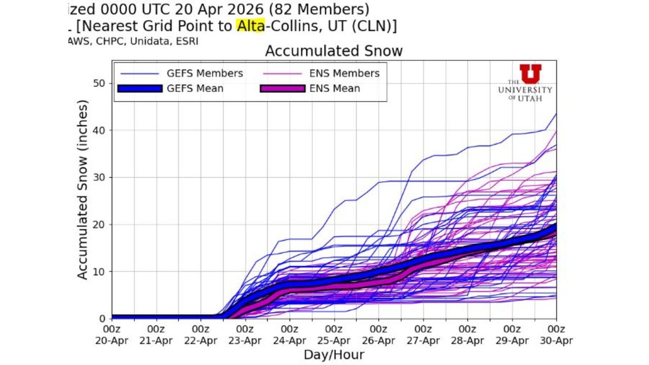
The snowfall accumulation chart for Alta-Collins tells the story clearly: the forecast ensemble mean tracks toward 15 to 20 inches total by month’s end, with some individual solutions pushing well above 30 to 40 inches if the more aggressive storm scenarios verify.
Areas in the Late-April Mountain Snow Zone
The snow is focused on northern Utah’s high terrain:
- Alta and Little Cottonwood Canyon: Directly in the bull’s-eye — ensemble mean pointing toward 15 to 20 inches accumulated through April 30, with high-end solutions exceeding 35 inches
- Snowbird and Brighton: Adjacent Wasatch Range resorts picking up similar totals as storm systems roll through
- Northern Utah mountains: The broader mountain zone from the Wasatch Front extending toward the Bear River Range in the path of multiple systems
- Logan and Cache Valley: Higher terrain north of Salt Lake City in the snow zone as storms track through
- Park City area: Lower elevation mountain terrain picking up lighter amounts as snow levels fluctuate between 6,500 and 8,000 feet
Primary Threats and Opportunities
The late-season snow brings both hazards and benefits:
- 6 to 16+ inches expected at Alta through April 30 — with ensemble spread showing significant upside potential above that range
- Snow levels 6,500 to 8,000 feet — fluctuating snow levels mean some storms clip higher valley elevations and canyon roads while others stay purely in the high country
- Multiple storm systems — this is not a single event but a series of storms stacking up through the final week of April, each adding to the total
- Canyon road impacts — Little Cottonwood Canyon, Big Cottonwood Canyon, and mountain passes face repeated rounds of winter driving conditions through month’s end
- Avalanche danger — repeated loading of the snowpack with late-season wet snow on top of existing base creates elevated avalanche conditions on steep terrain
Why This Is Big News for Utah Skiers and Water Supply
Salt Lake City, Utah sits at the base of one of the most famous ski mountains in the world — and Alta receiving 6 to 16+ inches in the final week of April is genuinely significant news for two very different reasons.
For skiers and snowboarders, late April snowfall at Alta is a gift. Spring skiing conditions typically deteriorate as the snowpack settles and crusts — but a fresh 6 to 16 inch dump refreshes the surface and extends quality ski days well into the final week of the season. Some ensemble members showing 30 to 40 inch totals by April 30 would represent a truly exceptional late-season powder stretch.
For Utah’s water supply, the late-season snowpack additions matter enormously. The Sierra Nevada and Wasatch snowpack feeds rivers, reservoirs, and municipal water systems through the summer months as it slowly melts. Every inch of late-season snow added to the mountain snowpack is water that will flow into the Great Salt Lake watershed and valley reservoirs during the hot, dry summer ahead.
The ensemble spread on the accumulation chart is notably wide — the difference between the low-end solutions (around 5 inches) and the high-end solutions (35+ inches) is significant. That spread reflects genuine uncertainty in the track and intensity of the individual storm systems. What is consistent across nearly all solutions is that meaningful additional snow is coming to Alta before April ends.
Multi-Day Pattern
April 22–23 — first storm system delivers initial snow accumulation above 8,000 feet, as already forecast with 6–9 inches at Alta from the Wednesday-Thursday system. April 24–27 — additional storm rounds continue stacking snow at high elevations as the pattern remains active. April 28–30 — final storm systems of the month push totals toward the ensemble mean of 15–20 inches, with some solutions going much higher. By May 1, the active late-season pattern begins to relax as the calendar turns.
What to Watch Next
- Storm-by-storm snow total updates for Alta and the Wasatch as each system approaches
- Whether any individual storm delivers a standout powder day in the final week of April
- Canyon road closure timing as snow levels drop with each system
- Avalanche advisories for Little Cottonwood and Big Cottonwood Canyons through April 30
- Final April snowpack totals and what they mean for Utah’s summer water supply outlook
Anyone planning mountain travel or ski trips across northern Utah through the end of April should expect repeated rounds of winter driving conditions in the canyons and be prepared for rapidly changing snow levels with each passing storm system.
WaldronNews.com will continue tracking Utah’s late-season mountain snow and provide updates as each storm system approaches through April 30.