
Kansas, Nebraska and Oklahoma Face Strong Tornadoes and Very Large Hail Sunday as Dryline Fires Along the KS-NE Border Into North-Central Oklahoma
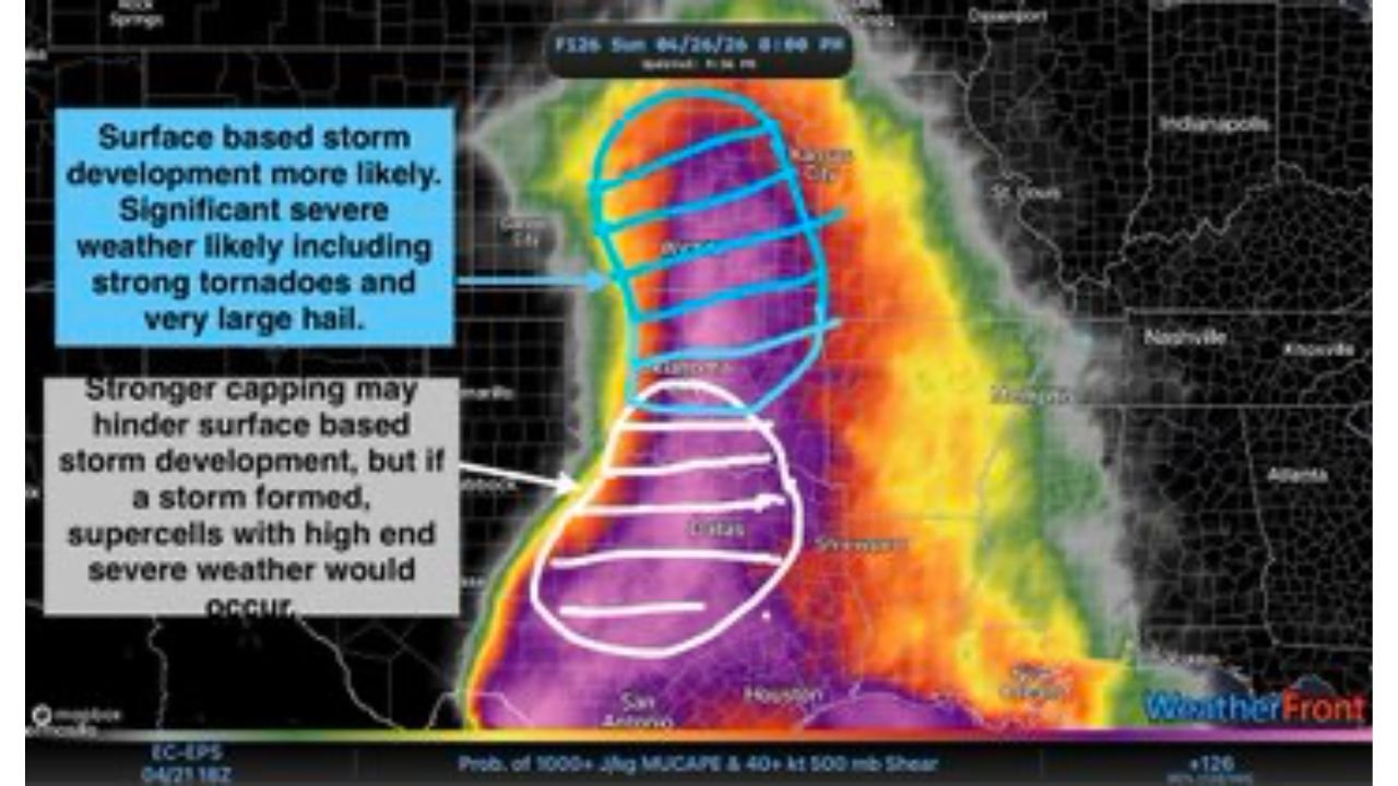
WICHITA, Kansas — Sunday, April 26 is coming into sharper focus — and the Kansas-Nebraska border down through north-central Oklahoma is now the primary target zone for what could be a high-end severe weather day. The atmosphere is loading up with 1,000+ J/kg MUCAPE combined with 40+ knot shear across a focused corridor, and any supercell that fires along the dryline Sunday afternoon will likely produce significant tornadoes and very large hail.
The forecast is honing in on a specific zone — and that specificity is exactly what makes Sunday dangerous.
The Sunday Severe Weather Target Zone
Forecasters are focusing on a tight corridor for storm development:
- Kansas-Nebraska border: The primary bull’s-eye for surface-based storm development Sunday afternoon — strongest convergence and dryline bulge creating maximum lift
- North-central Oklahoma: Southern end of the target zone where surface-based storms are more likely due to weaker capping
- Southern Kansas: Wichita corridor on the southern edge of the main development zone
- Northern Oklahoma: Tulsa area — stronger capping may hinder storm development here, but if a storm forms it would be a high-end supercell
- Nebraska: Southern Nebraska communities along the KS-NE border inside the primary development zone
Primary Threats Sunday
The atmospheric data is pointing toward a dangerous storm environment:
- Significant tornadoes — the zone from the KS-NE border into north-central Oklahoma shows surface-based storm development most likely, with significant severe weather including strong tornadoes explicitly flagged
- Very large hail — 1,000+ J/kg MUCAPE combined with 40+ knot shear supports hail-producing supercells capable of baseball size or larger
- High-end supercells — even in the northern zone where capping is stronger, if any storm breaks through the cap it immediately has access to a world-class severe weather environment
- Dryline-initiated discrete storms — the strongest surface convergence and dryline bulge are focused in the KS-NE border area, creating the most favorable lift for storm initiation Sunday afternoon
Why the KS-NE Border Is Ground Zero Sunday
Wichita, Kansas and surrounding communities need to understand what makes the Kansas-Nebraska border zone the specific focus for Sunday’s most dangerous storms.
Three distinct atmospheric signals are converging on this location simultaneously. First, stronger surface convergence — the dryline is developing a pronounced bulge right along the KS-NE border, concentrating the lift needed to break through the atmospheric cap and initiate storms. Second, stronger differential temperature advection at mid-levels combined with shortwave energy is specifically working to erode the cap in northern Oklahoma and Kansas — meaning the barrier that normally suppresses storm development weakens right where the best storm ingredients are located. Third, the 500mb jet stream pattern shows a powerful wind maximum racing directly over the target zone, providing the upper-level energy that organizes storms into rotating supercells.
The contrast between the northern and southern parts of Sunday’s target zone is critical to understand. In north-central Oklahoma, surface-based storm development is considered more likely because capping is weaker — storms can fire more easily but the environment is still loaded enough to produce significant tornadoes and very large hail. Further north along the KS-NE border, capping is stronger — meaning fewer storms will fire. But the ones that do break through the cap will encounter an even more explosive environment, potentially producing high-end supercells with violent tornado potential.
This is classic Tornado Alley dynamics. The cap acts as a pressure cooker — the stronger it is, the fewer storms fire, but the ones that do fire have access to all the unstable energy that has been building up beneath it all day.
The dryline moisture map shows exactly where the best storm fuel is pooling — a sharp boundary between dry western air and moist Gulf air running right through the KS-NE border zone. When that boundary sharpens Sunday afternoon under peak heating, storm initiation becomes increasingly likely along the convergence zone.
Multi-Day Pattern
Sunday April 26 is part of a remarkable 8-day severe weather sequence running from Thursday April 23 through Monday April 27. Sunday represents the Southern Plains chapter of this stretch — the dryline event over Kansas and Oklahoma. By Monday, the energy shifts eastward and the primary threat moves into the Mississippi Valley, Tennessee, and Alabama with a large warm sector setup. Communities in the Mid-South that watch Sunday’s Kansas storms should understand Monday is coming for them next.
What to Watch Next
- Sunday morning cap strength updates across northern Oklahoma and southern Kansas — whether the cap erodes enough for widespread storm initiation
- Dryline position and bulge development Sunday afternoon — the sharper the bulge, the more focused and dangerous storm initiation becomes
- Tornado watch issuances Sunday afternoon for the KS-NE border and north-central Oklahoma
- Whether northern Kansas cap breaks — if it does, the storms that fire will be high-end supercells in a world-class environment
- Storm reports Sunday evening as the first supercells mature and begin producing tornadoes and large hail
Residents along the Kansas-Nebraska border, southern Nebraska, and north-central Oklahoma need to be in their safest location before Sunday afternoon storms develop. The window between storm initiation and violent tornado can be extremely short in environments like this — do not wait for a warning to be posted before taking shelter.
WaldronNews.com will continue tracking Sunday’s dryline severe weather threat and provide updates as storm initiation timing and the cap situation become clearer through the weekend.