
Eastern Kansas Faces Strong Tornadoes and Large Hail Today as Wichita Corridor Gets Greater Tornado Threat While Oklahoma Watches for EF2 Supercells
WICHITA, Kansas — Today is the day — Thursday, April 23 severe weather is arriving across the Plains and Midwest, and two specific zones are drawing serious attention. Eastern Kansas is facing a greater tornado threat with strong tornadoes possible along the cold front, while Oklahoma carries a conditional all-hazards threat where isolated supercells capable of EF2+ tornadoes could develop if the cap breaks. Damaging winds and large hail are the primary hazards across the broader region through the afternoon and evening hours.
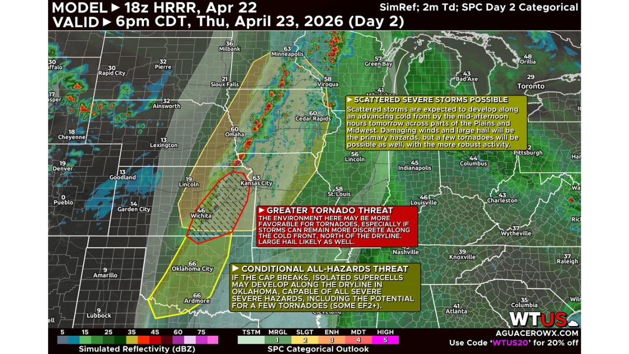
The radar simulation valid for 6 PM CDT Thursday shows the cold front driving a line of storms from Sioux Falls through Omaha and Kansas City, with the most concerning activity focused in the Wichita corridor where a red-outlined Greater Tornado Threat zone is explicitly drawn.
Thursday’s Two Zones of Greatest Concern
The threat splits into two distinct areas with different storm modes:
- Eastern Kansas — Greater Tornado Threat: Wichita and the surrounding corridor sitting inside the red-outlined zone where the environment is most favorable for tornadoes — storms developing along the cold front north of the dryline have discrete supercell potential with strong tornado and large hail threat; a strong tornado or two cannot be ruled out
- Oklahoma — Conditional All-Hazards Threat: Oklahoma City corridor in the yellow zone where isolated supercells may develop along the dryline if the cap breaks — all severe hazards possible including EF2+ tornadoes; more uncertain but high-end if storms fire
Broader Severe Weather Zone Thursday
Scattered severe storms are expected along the cold front across a wide area:
- Kansas: Wichita in the greatest tornado threat zone — Kansas City on the eastern edge of storm activity
- Nebraska: Omaha and Lincoln along the cold front corridor with damaging winds and hail
- Iowa: Des Moines and Cedar Rapids in the path of the advancing cold front storm line
- Minnesota: Minneapolis on the northern end of the scattered severe threat
- Missouri: Kansas City area where cold front storms push through Thursday evening
- Oklahoma: Oklahoma City and surrounding areas — conditional supercell threat if cap breaks
Primary Threats Today
Thursday’s storm environment delivers multiple dangerous hazards:
- Strong tornadoes — eastern Kansas explicitly flagged for greater tornado threat with a strong tornado or two not ruled out along the cold front north of the dryline
- EF2+ tornadoes — Oklahoma’s conditional threat specifically mentions some strong tornadoes reaching EF2 intensity or higher if supercells develop along the dryline
- Large hail — likely across both the Kansas cold front zone and the Oklahoma dryline supercell corridor
- Damaging winds — widespread 60+ mph gusts along the advancing cold front from Nebraska through Iowa and Minnesota
- Discrete supercell potential in Kansas — storms that remain isolated along the cold front in eastern Kansas have the most favorable environment for organized rotation and tornado production
Why Wichita Is in the Most Dangerous Position Today
Wichita, Kansas sits squarely inside the red Greater Tornado Threat zone — the highest-concern area on today’s outlook. The reason eastern Kansas is flagged above the rest of the cold front corridor comes down to storm mode. Along most of the cold front from Nebraska through Iowa, storms will organize into a line — producing damaging winds as the primary threat. But in eastern Kansas, where the cold front intersects near the dryline boundary, individual storms have a better chance of staying discrete rather than merging into a line.
Discrete supercells are the most dangerous tornado producers. When a storm stays isolated, it has exclusive access to all the wind shear, instability, and rotation in the atmosphere without competition from neighboring storms. In the Wichita corridor Thursday, that combination of discrete storm mode plus a favorable shear environment creates the elevated tornado potential that earned the red Greater Tornado Threat designation.
The Oklahoma situation is different — and the honest uncertainty matters. The cap across Oklahoma has been stubborn all week, and whether it breaks enough for isolated supercells to fire along the dryline remains a question. But forecasters are clear: if storms do develop in Oklahoma, the environment is loaded enough to produce all hazards including EF2 or stronger tornadoes. The conditional nature of the threat does not reduce its severity — it just means storm initiation is the question, not storm intensity.
For communities along the cold front corridor from Omaha through Kansas City, the primary threats are damaging winds and large hail as the squall line pushes through Thursday afternoon and evening. Have outdoor furniture secured and vehicles in garages before afternoon storms arrive.
Multi-Day Pattern
Thursday opens a historic severe weather stretch that runs through Monday April 27. Today’s Plains and Midwest threat is just the first chapter. Sunday brings the classic Oklahoma-Kansas dryline outbreak with very high ceiling. Monday targets the Mississippi Valley and Deep South with a large warm sector tornado setup. Every day between now and Monday carries a threat somewhere across the country — and communities need to track which day their region is most at risk.
What to Watch Next
- Whether the cap breaks across Oklahoma this afternoon — storm initiation timing will determine how serious Thursday’s Oklahoma threat becomes
- Tornado watch issuances for eastern Kansas this afternoon — likely between 2 and 5 PM CDT
- Storm reports from the Wichita corridor as cold front supercells develop and mature Thursday afternoon
- Squall line arrival timing for Omaha, Des Moines, and Kansas City as the front pushes east Thursday evening
- Friday’s setup update as energy from Thursday’s system begins reloading for the weekend outbreak
Residents across Wichita and eastern Kansas should be in a safe location before Thursday afternoon storms develop — have your shelter ready before 2 PM. Oklahoma City residents should monitor conditions closely — if tornado watches are issued, treat them seriously even though storm initiation remains uncertain.
WaldronNews.com will continue tracking Thursday’s severe weather as storms develop and provide live updates through the afternoon and evening.